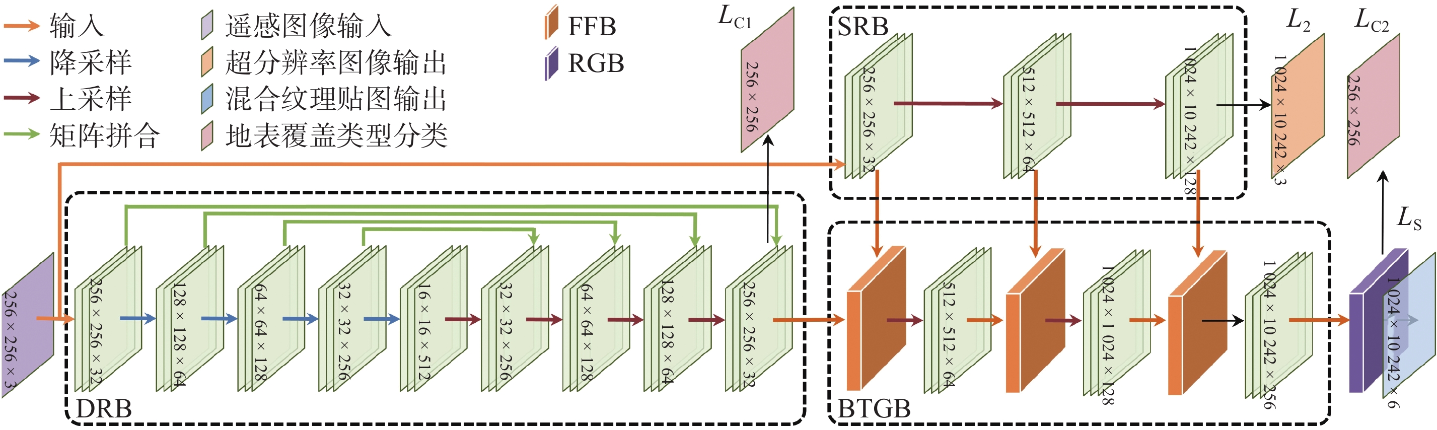
| 1 |
RODRIGUEZ-GALIANO V F, CHICA-OLMO M, ABARCA-HERNANDEZ F, et al. Random forest classification of Mediterranean land cover using multi-seasonal imagery and multi-seasonal texture. Remote Sensing of Environment, 2012, 121, 93- 107.
|
| 2 |
ZHANG T X, SU J Y, XU Z Y, et al. Sentinel-2 satellite imagery for urban land cover classification by optimized random forest classifier. Applied Sciences, 2021, 11 (2): 543.
doi: 10.3390/app11020543
|
| 3 |
RAKHLIN A, DAVYDOW A, NIKOLENKO S. Land cover classification from satellite imagery with u-net and lovász-softmax loss [C]// Proceedings of the IEEE Conference on Computer Vision and Pattern Recognition Workshops. IEEE, 2018: 262-266.
|
| 4 |
RONNEBERGER O, FISCHER P, BROX T. U-Net: Convolutional networks for biomedical image segmentation [C]// International Conference on Medical Image Computing and Computer-Assisted Intervention. Cham: Springer, 2015: 234-241.
|
| 5 |
ZHANG W, TANG P, ZHAO L. Fast and accurate land-cover classification on medium-resolution remote-sensing images using segmentation models. International Journal of Remote Sensing, 2021, 42 (9): 3277- 3301.
|
| 6 |
WAMBUGU N, CHEN Y, XIAO Z, et al. A hybrid deep convolutional neural network for accurate land cover classification. International Journal of Applied Earth Observation and Geoinformation, 2021, 103, 102515.
|
| 7 |
LI R, ZHENG S Y, DUAN C X, et al. Land cover classification from remote sensing images based on multi-scale fully convolutional network. Geo-Spatial Information Science, 2022, 25 (2): 278- 294.
|
| 8 |
SMELIK R M, DE KRAKER K J, GROENEWEGEN S, et al. A survey of procedural methods for terrain modelling [C]// Proceedings of the CASA Workshop on 3D Advanced Media in Gaming and Simulation (3AMIGAS). 2009: 25-34.
|
| 9 |
陈晓铮, 李震霄. 一种基于表面积比例的地形纹理贴图算法. 计算机仿真, 2007, 24 (8): 174- 177.
|
| 10 |
GOODFELLOW I J, POUGET-ABADIE J, MIRZA M, et al. Generative adversarial nets [C]// Proceedings of the 27th International Conference on Neural Information Processing Systems. Cambridge: MIT Press, 2014: 2672-2680
|
| 11 |
ZHU J Y, PARK T, ISOLA P, et al. Unpaired image-to-image translation using cycle-consistent adversarial networks [C]// 2017 IEEE International Conference on Computer Vision (ICCV). IEEE, 2017: 2242-2251. DOI: 10.1109/ICCV.2017.244.
|
| 12 |
ISOLA P, ZHU J Y, ZHOU T, et al. Image-to-image translation with conditional adversarial networks [C]// 2017 IEEE Conference on Computer Vision and Pattern Recognition (CVPR). IEEE, 2017: 1125-1134. DOI: 10.1109/CVPR.2017.632.
|
| 13 |
LI W, LIANG Z X, MA P, et al. Hausdorff GAN: Improving GAN generation quality with Hausdorff metric [J]. IEEE Transactions on Cybernetics, 2022, 52(10): 10407-10419. DOI: 10.1109/TCYB.2021.3062396.
|
| 14 |
ZHANG H, KOH J Y, BALDRIDGE J, et al. Cross-modal contrastive learning for text-to-image generation [C]// 2021 IEEE/CVF Conference on Computer Vision and Pattern Recognition (CVPR). IEEE, 2021: 833-842. DOI: 10.1109/CVPR46437.2021.00089.
|
| 15 |
LEE K S, TRAN N T, CHEUNG N M. Infomax-GAN: Improved adversarial image generation via information maximization and contrastive learning [C]// 2021 IEEE Winter Conference on Applications of Computer Vision (WACV). IEEE, 2021: 3942-3952. DOI: 10.1109/WACV48630.2021.00399.
|
| 16 |
CHEN J, LIU G, CHEN X. AnimeGAN: A novel lightweight gan for photo animation [C]// International Symposium on Intelligence Computation and Applications. Singapore: Springer, 2019: 242-256.
|
| 17 |
XU W J, LONG C J, WANG R S, et al. DRB-GAN: A dynamic resblock generative adversarial network for artistic style transfer [C]// 2021 IEEE/CVF International Conference on Computer Vision (ICCV). IEEE, 2021: 6383-6392. DOI: 10.1109/ICCV48922.2021.00632.
|
| 18 |
XIAN W Q, SANGKLOY P, AGRAWAL V, et al. Texturegan: Controlling deep image synthesis with texture patches [C]// 2018 IEEE/CVF Conference on Computer Vision and Pattern Recognition. IEEE, 2018: 8456-8465. DOI: 10.1109/CVPR.2018.00882.
|
| 19 |
FRÜHSTÜCK A, ALHASHIM I, WONKA P. Tilegan: Synthesis of large-scale non-homogeneous textures. ACM Transactions on Graphics (ToG), 2019, 38 (4): 0:1- 0:11.
|
| 20 |
KIM H, DISCHLER J M, RUSHMEIER H, et al. Edge-based procedural textures. The Visual Computer, 2021, 37 (9): 2595- 2606.
|
| 21 |
BECKHAM C, PAL C. A step towards procedural terrain generation with GANs [EB/OL]. (2017-07-11)[2022-02-20]. https://arxiv.org/pdf/1707.03383v1.pdf.
|
| 22 |
DRUSCH M, DEL BELLO U, CARLIER S, et al. Sentinel-2: ESA’s optical high-resolution mission for GMES operational services. Remote Sensing of Environment, 2012, 120, 25- 36.
|
 ), 陈敏刚2
 中文核心期刊