华东师范大学学报(自然科学版) ›› 2026, Vol. 2026 ›› Issue (1): 132-139.doi: 10.3969/j.issn.1000-5641.2026.01.012

• 流域污染控制与碳中和路径探索 • 上一篇    

自下而上的高分辨率水污染源排放清单核算方法及空间分析研究

王玉杰1,2,3(), 薛咪1,2,3, 罗锦洪2,4,*(), 张伟锋1,2,3, 马秀娟1,2,3, 张城1,2,3   

  1. 1. 山西省生态环境规划和技术研究院, 太原 030009
    2. 水污染防治与利用山西省重点实验室, 太原 030009
    3. 黄河流域生态保护和高质量发展联合研究中心, 北京 100002
    4. 山西省生态环境监测和应急保障中心, 太原 030024
  • 收稿日期:2025-07-24 接受日期:2025-11-21 出版日期:2026-01-25 发布日期:2026-01-29
  • 通讯作者: 罗锦洪 E-mail:wyj408032118@163.com;sxhbljh@163.com
  • 作者简介:王玉杰, 女, 高级工程师, 研究方向为水生态环境. E-mail: wyj408032118@163.com
  • 基金资助:
    水污染防治与利用山西省重点实验室项目(202404010931034); 黄河流域生态保护和高质量发展联合研究项目(2022-YRUC-01-050206)

A bottom-up high-resolution water pollutant emission inventory accounting method and spatial analysis

Yujie WANG1,2,3(), Mi XUE1,2,3, Jinhong LUO2,4,*(), Weifeng ZHANG1,2,3, Xiujuan MA1,2,3, Cheng ZHANG1,2,3   

  1. 1. Shanxi Provincial Institute of Ecological Environment Planning and Technology Research, Taiyuan 030009, China
    2. Shanxi Key Laboratory of Water Pollution Prevention and Utilization, Taiyuan 030009, China
    3. National Joint Research Center for Ecological Conservation and High Quality Development of the Yellow River Basin, Beijing 100012, China
    4. Shanxi Provincial Center for Ecological and Environmental Monitoring and Emergency Response, Taiyuan 030024, China
  • Received:2025-07-24 Accepted:2025-11-21 Online:2026-01-25 Published:2026-01-29
  • Contact: Jinhong LUO E-mail:wyj408032118@163.com;sxhbljh@163.com

摘要:

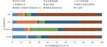
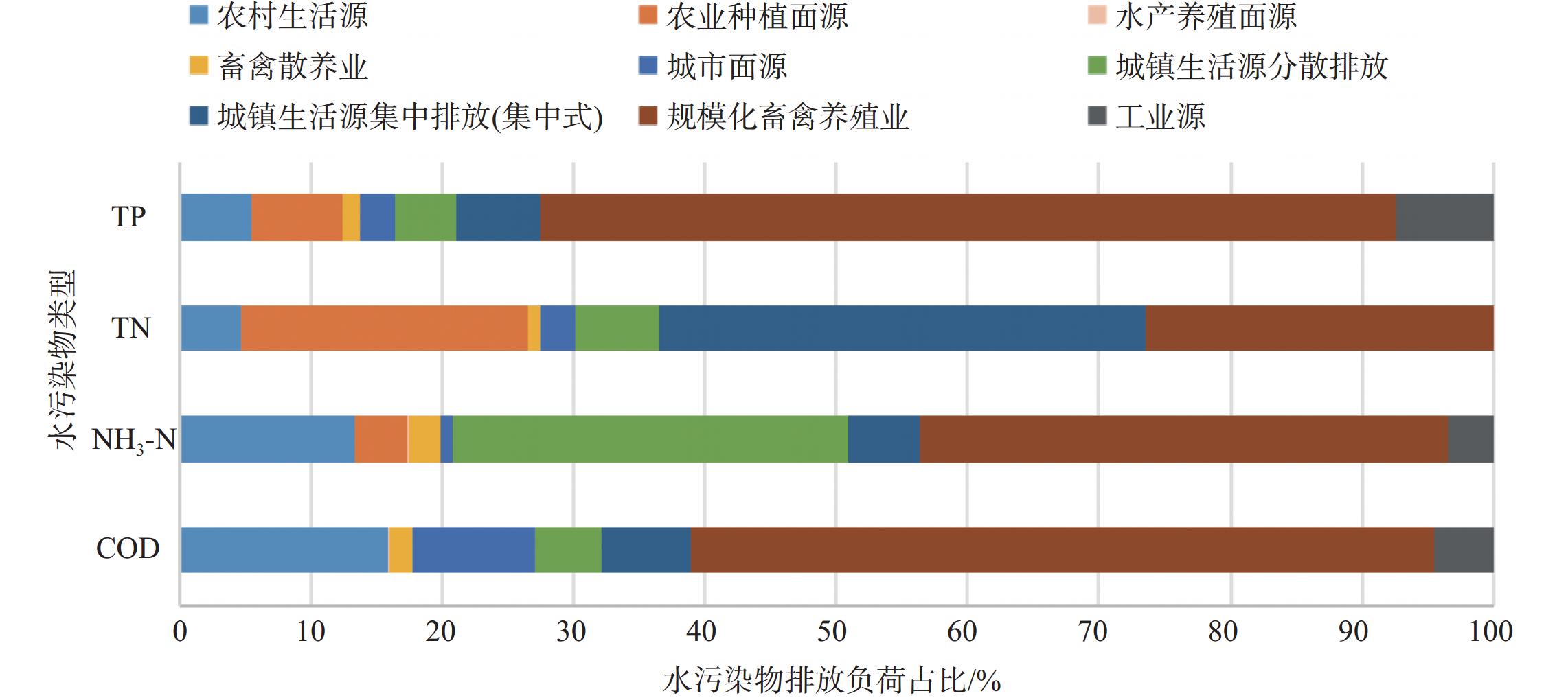
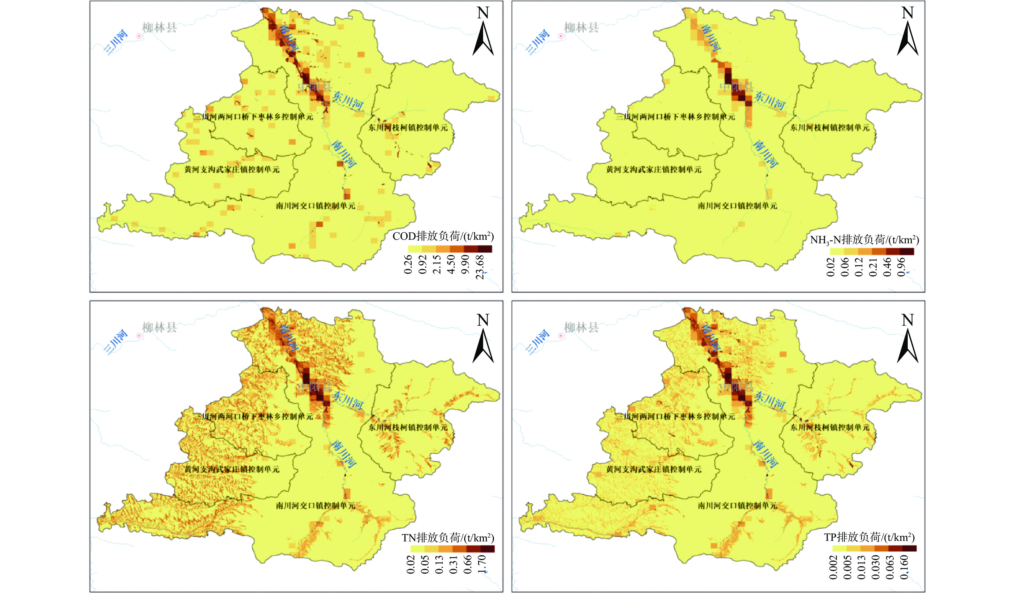
为解决水污染源排放清单空间精度不足的问题, 本研究基于ArcGIS空间分析技术, 通过自下而上创新核算路径, 减小由行政区排放量向空间网格分配带来的误差, 形成网格—控制单元—流域三级尺度的空间高分辨率水污染源排放清单. 以具有典型黄土高原山区流域特点的南川河流域为研究区域, 全面梳理空间高分辨率水污染源排放清单编制过程, 核算南川河流域各类污染源的化学需氧量 (COD)、氨氮 (NH3-N)、总氮 (TN)和总磷 (TP)排放量, 并通过单位面积污染物排放量统计及核密度分析, 揭示面源、点源空间排放特征. 结果表明: 采取自下而上的核算路径方法可行, 建立网格尺度的空间高分辨率水污染源排放清单体系, 有利于衔接当前流域水生态环境保护规划、生态环境分区管控的应用需求, 为实现流域水环境精细化管理提供支撑. 本研究的完成掌握了南川河流域水污染物排放情况, 污染物排放以点源为主 (COD和TP的贡献率分别为69.72%和80.16%), 其中规模化畜禽养殖业是核心排放源 (占COD总量的58.39%). 农村生活面源与城市面源污染不容忽视, 两者的COD排放量占全源排放量的近四分之一. 污染物排放空间分布高度集中, 沿南川河干流及东川河两岸集聚. 排放清单研究与南川河污染源排放数据有力地支撑了黄河流域生态保护和高质量发展联合研究“一市一策”驻点帮扶工作, 具有重要的现实意义.

关键词: 自下而上, 高分辨率, 排放清单, 空间分布, 黄河流域

Abstract:

To address the spatial resolution limitations of water pollutant emission inventories, this study employed ArcGIS spatial analysis technology and adopted a bottom-up innovative accounting approach to minimize errors derived from allocating administrative-level emissions to spatial grids. A high-resolution water pollutant emission inventory system was developed across three-tiered grid, control unit, and watershed scales. Focusing on the Nanchuan River Basin, a typical Loess Plateau mountainous watershed, the study comprehensively detailed the compilation process of this spatially refined inventory. Emissions of chemical oxygen demand (COD), ammonia nitrogen (NH3-N), total nitrogen (TN), and total phosphorus (TP) from various pollution sources were quantified, and the spatial emission characteristics of non-point and point sources were revealed through pollutant load per unit area statistics and kernel density analysis. The study produced several key findings: (1) The bottom-up accounting method proved feasible, establishing a grid-scale high-resolution emission inventory system that aligns with watershed ecological protection planning and partitioned environmental management needs, thereby supporting refined water environmental governance. (2) Point sources dominated pollutant emissions in the Nanchuan River Basin (contributing 69.72% of COD and 80.16% of TP), with large-scale livestock farming as the primary source (58.39% of total COD). (3) Rural and urban non-point sources were significant, jointly accounting for nearly one-fourth of COD emissions. (4) Emissions exhibited high spatial concentration along the mainstream of the Nanchuan River and the banks of the Dongchuan River. This inventory research and emission data robustly supported the “one city, one policy” initiative under the Joint Research on Ecological Protection and High-Quality Development in the Yellow River Basin, demonstrating substantial practical significance.

Key words: bottom-up, high-resolution, emission inventory, spatial distribution, the Yellow River Basin

中图分类号: