华东师范大学学报(自然科学版) ›› 2022, Vol. 2022 ›› Issue (1): 148-158.doi: 10.3969/j.issn.1000-5641.2022.01.016

• 地理学 • 上一篇    

山西太原田庄断裂晚更新世活动的证据

韩晓飞1,2(), 杜燕林3, 贾建喜1,2, 董斌1,2, 史双双1,2   

  1. 1. 山西省地震局, 太原 030021
    2. 太原大陆裂谷动力学国家野外科学观测研究站, 太原 030025
    3. 中国地震局 地球物理勘探中心, 郑州 450002
  • 收稿日期:2020-07-23 出版日期:2022-01-25 发布日期:2022-01-18
  • 作者简介:韩晓飞, 男, 高级工程师, 研究方向为地震地质及地球物理. E-mail: 38094048@qq.com
  • 基金资助:
    山西省自然科学基金面上项目(201901D111462); 山西省青年基金面上项目(201701D221019); 山西太原大陆裂谷动力学国家野外科学观测研究站资助(NORSTY20-06); 山西省地震局资助(SBK-2221)

The basis of late Pleistocene activity at the Tianzhuang fault in Taiyuan, Shanxi Province

Xiaofei HAN1,2(), Yanlin DU3, Jianxi JIA1,2, Bin DONG1,2, Shuangshuang SHI1,2   

  1. 1. Shanxi Earthquake Administration, Taiyuan 030021, China
    2. Taiyuan national field scientific observation and research station of continental rift dynamics, Taiyuan 030025, China
    3. Geophysical Exploration Center, China Earthquake Administration, Zhengzhou 450002, China
  • Received:2020-07-23 Online:2022-01-25 Published:2022-01-18

摘要:

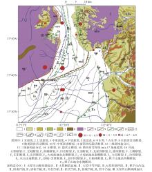
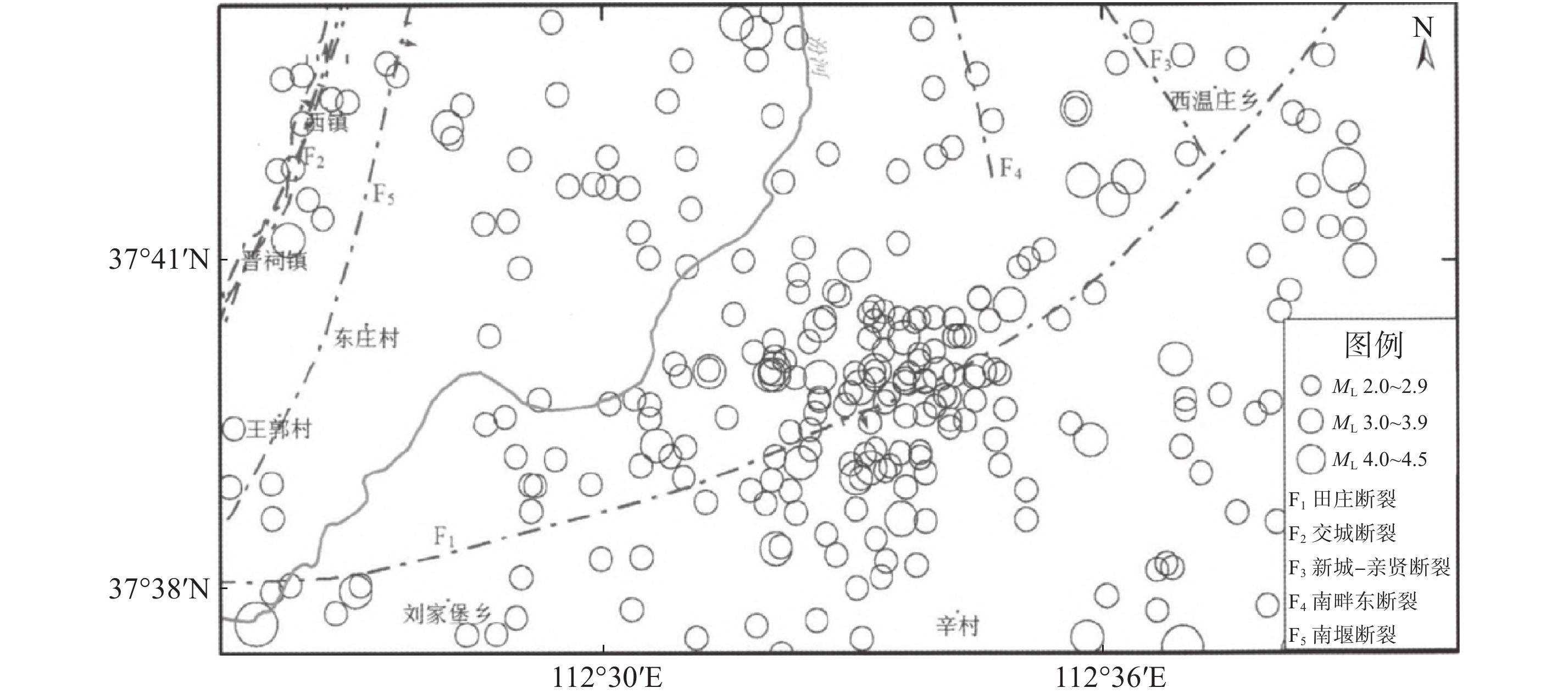
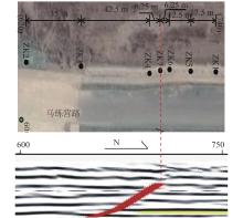
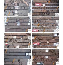
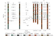
田庄断裂为北东东向的斜穿太原盆地北部的隐伏活动断裂, 通过在马练营路附近实施横跨田庄断裂的联合钻孔勘探, 发现地层呈现出3段明显的河-湖-沼泽相沉积旋回特征: 80 ~ 60 m段, 沉积环境逐步趋于频繁, 沉积相为湖泊→沼泽; 60 ~ 30 m段, 沉积环境两次经由频繁趋于稳定再到频繁, 沉积相为河流→沼泽→河流→湖泊→沼泽→河流; 30 ~ 0 m段, 沉积环境逐步趋于稳定, 沉积相为沼泽→湖泊→沼泽. 地层岩性表现出: 青灰色粉质黏土在从南至北方向上呈现出深度变深, 终止深度变浅, 在钻孔ZK3←→ZK4←→ZK7间均出现量级的转折变化; 黄褐、褐黄色粉砂、细砂在从南至北方向上整体出现深度在20 ~ 30 m, 浮动不大, 终止深度变深. 田庄断裂断错地层主要有3套, 均为晚更新世地层, 未穿透上更新统, 由此判定目标断裂为晚更新世活动断层, 从上到下, 断错地层错距逐渐加大, 依次为0.4 m、3.5 m、7.2 m, 错距在钻孔所揭露深度内有两次3 m左右的同震位移, 可以判断在该识别层内发生两次主错动事件, 这为分析田庄断裂的地震危险性提供了可靠的地质证据.

关键词: 田庄断裂, 沉积相, 错断地层

Abstract:

In this paper, the presence of the Tianzhuang fault was confirmed using a combination of petroleum geophysical exploration, geology, remote sensing, and other data. The study concluded that the fault originated from the west of Tiancun, Jinyuan District, Taiyuan City with a total length of about 35 km from Houjiazhai to Tianzhuang. The fault trends from west to east with the pattern EW-NEE-NE, and tends to the SE as a high-angle normal fault. The Tianzhuang fault is a concealed fault associated with the piedmont fault of the East and West Mountains of the Taiyuan Basin. Through the joint drilling exploration across the Tianzhuang fault, near the Ma Lianying Road, there were three distinct sedimentary cycles of river lake swamp facies found in the strata: in the 80 ~ 60 m section, the sedimentary environment tends to frequent gradually, and the sedimentary facies is lake→swamp; in the 60 ~ 30 m section, the sedimentary environment tends to be stable and frequent twice, and the sedimentary facies is river→swamp→river→lake→swamp→river; in the 30 ~ 0 m section, the sedimentary environment tends to be stable gradually, and the sedimentary facies is swamp→lake→swamp. The Quaternary strata in the site gradually thickens from north to south in the horizontal direction, and the coarse-grained deposits become thinner. There is a magnitude change in the borehole, ZK3←→ZK4←→ZK7, and the first layer is thick in the vertical direction. Particle deposition occurs at 20 ~ 30 m, and the floating is not large; the sedimentation cycle number is roughly “M” from deep to shallow, and the sedimentation number reaches a peak at 30 ~ 40 m and 50 ~ 60 m. From the perspective of detecting the strata, all the boreholes in the silty layer of the Holocene boundary were exposed, and the depth was relatively small. It is believed that the sampling rate of the bored sand layer is not the same and hence it is expected that the fault of the Tianzhuang fault is not broken. There are three primary sets of fault-breaking strata in the Tianzhuang fault, all of which are from the Late Pleistocene strata; these did not penetrate the Upper Pleistocene, and thus the target fault was determined to be the late Pleistocene active fault. From top to bottom, the offset of faulted strata increases gradually: 0.4 m, 3.5 m, and 7.2 m, in turn. There are two coseismic displacements of about 3 meters in the exposed depth of the borehole, which can be used to judge the occurrence of two main dislocation events in the identified layer. This provides reliable geological evidence for analyzing the seismic risk of the Tianzhuang fault.

Key words: Tianzhuang fault, sedimentary facies, fault stratum

中图分类号: