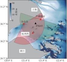
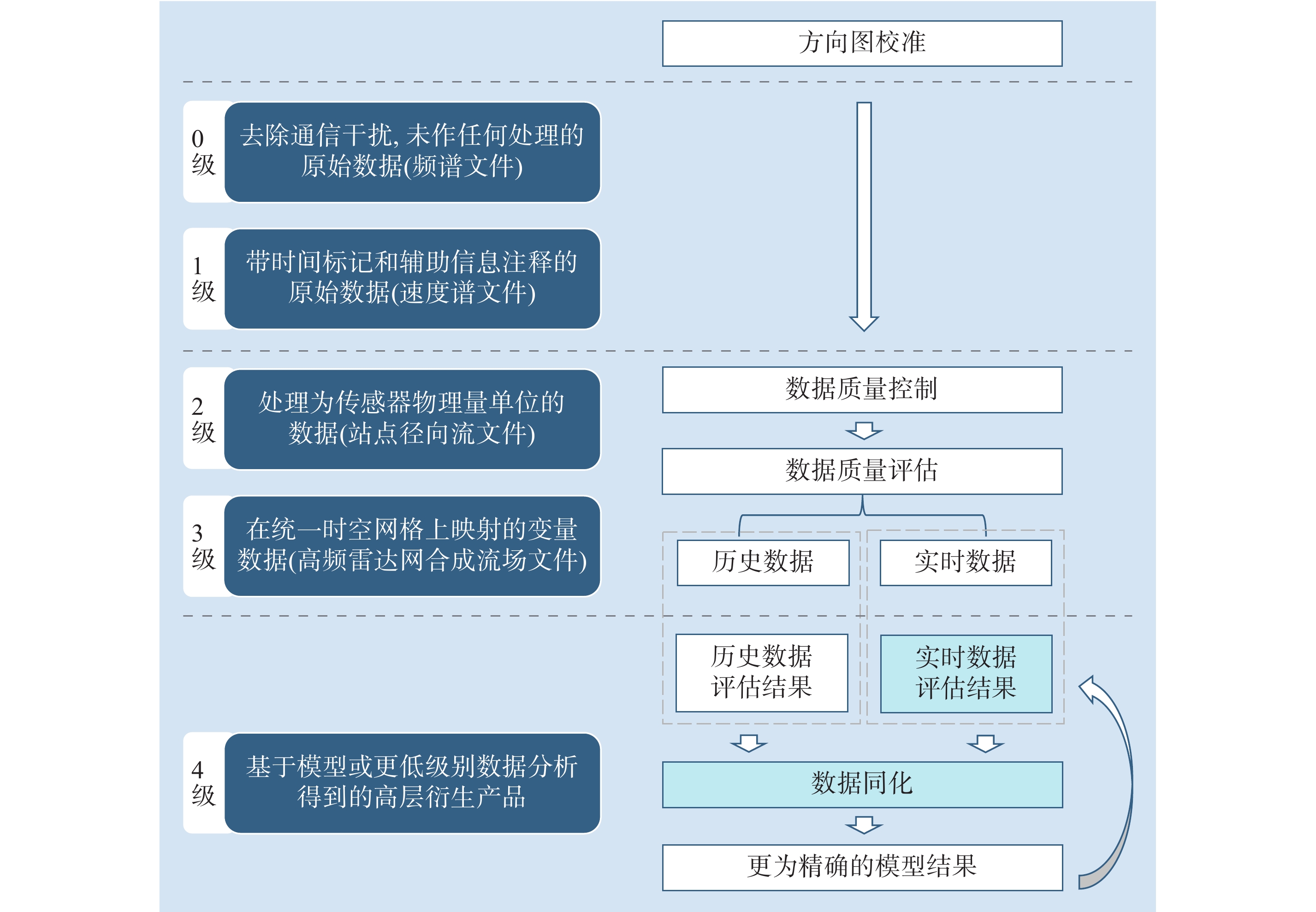
| 1 |
刘玉龙, 李程, 杨扬, 等.. 舟山海域高频地波雷达表层流探测试验. 海洋通报, 2023, 42 (2): 121- 127.
|
| 2 |
唐诚, 郑向阳, 李艳芳, 等.. 山东半岛北部海洋动力环境的高频地波雷达观测. 海洋科学, 2017, 41 (5): 85- 92.
|
| 3 |
张文雅, 潘广维, 丘仲锋, 等.. 基于高频地波雷达观测的连云港近岸海表流时空特征分析. 人民珠江, 2021, 42 (5): 57- 66.
|
| 4 |
张景思, 吴伦宇, 葛建忠, 等.. 基于高频地波雷达的多时间尺度海流研究. 海洋学报, 2022, 44 (6): 128- 139.
|
| 5 |
许张柳, 吴伦宇, 焦阳, 等.. 高频地波雷达在海洋学中的应用综述. 海洋预报, 2023, 40 (4): 122- 129.
|
| 6 |
赖叶平. 基于紧凑型高频雷达的海洋表面流场探测及海流特性分析 [D]. 武汉: 武汉大学, 2018.
|
| 7 |
COSOLI S, DRAGO A, CIRAOLO G, et al.. Tidal currents in the Malta–Sicily Channel from high-frequency radar observations. Continental Shelf Research, 2015, 109, 10- 23.
|
| 8 |
MANSO-NARVARTE I, CABALLERO A, RUBIO A, et al.. Joint analysis of coastal altimetry and high-frequency (HF) radar data: Observability of seasonal and mesoscale ocean dynamics in the Bay of Biscay. Ocean Science, 2018, 14 (5): 1265- 1281.
|
| 9 |
ZHANG W, EBUCHI N, FUKAMACHI Y, et al.. Sea ice observation with oceanographic HF radar. IEEE Transactions on Geoscience and Remote Sensing, 2020, 58 (1): 378- 390.
|
| 10 |
徐全军, 吴雄斌, 周恒, 等.. OSMAR071G地波雷达对“莫兰蒂” 台风风眼的观测. 海洋技术学报, 2017, 36 (5): 99- 103.
|
| 11 |
ROARTY H, SMITH M, EVANS C, et al. Quality control for a network of SeaSonde HF radars [C]// OCEANS 2014 – TAIPEI, Taipei, China. IEEE, 2014: 1-5.
|
| 12 |
MANTOVANI C, CORGNATI L, HORSTMANN J, et al.. Best practices on high frequency radar deployment and operation for ocean current measurement. Frontiers in Marine Science, 2020, 7, 210.
|
| 13 |
FUJII S, HERON M L, KIM K, et al.. An overview of developments and applications of oceanographic radar networks in Asia and Oceania countries. Ocean Science Journal, 2013, 48 (1): 69- 97.
|
| 14 |
ROARTY H, UPDYKE T, NAZZARO L, et al.. Real-time quality assurance and quality control for a high frequency radar network. Frontiers in Marine Science, 2024, 11, 1352226.
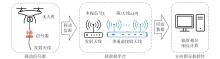
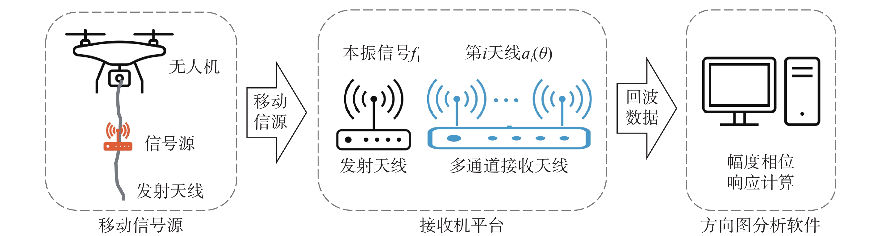
|
| 15 |
赖叶平, 王玉皞, 周浩, 等.. 便携式近程高频地波雷达海流对比试验. 华中科技大学学报(自然科学版), 2020, 48 (5): 32- 36.
|
| 16 |
BARRICK D E, LIPA B J. Using antenna patterns to improve the quality of SeaSonde HF radar surface current maps [C]// Proceedings of the IEEE Sixth Working Conference on Current Measurement, San Diego, CA, USA. IEEE, 1999: 5-8.
|
| 17 |
COSOLI S, MAZZOLDI A, GAČIĆ M.. Validation of surface current measurements in the northern adriatic sea from high-frequency radars. Journal of Atmospheric and Oceanic Technology, 2010, 27 (5): 908- 919.
|
| 18 |
BARRICK D.. First-order theory and analysis of MF/HF/VHF scatter from the sea. IEEE Transactions on Antennas and Propagation, 1972, 20 (1): 2- 10.
|
| 19 |
黄朝. 高频地波雷达阵列DOA估计与幅相误差校正研究 [D]. 广西 桂林: 广西师范大学, 2022.
|
| 20 |
KOHUT J T, GLENN S M.. Improving HF radar surface current measurements with measured antenna beam patterns. Journal of Atmospheric and Oceanic Technology, 2003, 20 (9): 1303.
|
| 21 |
PADUAN J D, KIM K C, COOK M S, et al.. Calibration and validation of direction-finding high-frequency radar ocean surface current observations. IEEE Journal of Oceanic Engineering, 2006, 31 (4): 862- 875.
|
| 22 |
EMERY B M, WASHBURN L, WHELAN C, et al.. Measuring antenna patterns for ocean surface current HF radars with ships of opportunity. Journal of Atmospheric and Oceanic Technology, 2014, 31 (7): 1564- 1582.
|
| 23 |
SHI X Z, XU X J, SHI Z H, et al.. Measurements of the cross-loop antenna patterns in high-frequency surface wave radars. IEEE Geoscience and Remote Sensing Letters, 2015, 12 (6): 1272- 1276.
|
| 24 |
WASHBURN L, ROMERO E, JOHNSON C, et al.. Measurement of antenna patterns for oceanographic radars using aerial drones. Journal of Atmospheric and Oceanic Technology, 2017, 34 (5): 971- 981.
|
| 25 |
WHELAN C, EMERY B, TEAGUE C, et al. Automatic calibrations for improved quality assurance of coastal HF radar currents [C]// 2012 Oceans. IEEE, 2012: 1-4.
|
| 26 |
廖一迁, 岳显昌, 吴雄斌, 等.. 基于AIS和Canopy + Kmeans算法的高频雷达阵列幅相校准. 现代雷达, 2023, 45 (9): 9- 15.
|
| 27 |
张东亮, 王心鹏, 王斌, 等.. 高频地波雷达天线方向图校准方法研究. 海洋技术学报, 2022, 41 (5): 53- 59.
|
| 28 |
张苗苗. 高频地波雷达海洋信息反演及质量评估技术研究 [D]. 哈尔滨: 哈尔滨工业大学, 2023.
|
| 29 |
方今, 刘京城.. 基于向量自回归模型的高频地波雷达海流异常值的识别算法研究. 海洋技术学报, 2021, 40 (4): 30- 36.
|
| 30 |
肖江洪, 陈泽宗, 赵晨, 等.. 基于数据同化的高频地波雷达海流数据质量分析方法. 武汉大学学报(理学版), 2017, 63 (3): 213- 218.
|
| 31 |
高玉斌, 岳显昌, 周庆, 等.. 高频地波雷达射频干扰慢时域抑制方法. 雷达科学与技术, 2023, 21 (1): 53- 63.
|
| 32 |
XIE J R, JIANG H, SONG W, et al.. A novel quality control method of time-series ocean wave observation data combining deep-learning prediction and statistical analysis. Journal of Sea Research, 2023, 195, 102439.
|
| 33 |
LE GUEN R. Machine Learning applied to Argo floats temperature and salinity Delayed-Mode Quality Control (Core-Argo DMQC) [R/OL]. French Research Institute for Exploitation of the Sea (IFREMER), 2019.
|
| 34 |
ZHOU Y S, QIN R F, XU H P, et al.. A data quality control method for seafloor observatories: The application of observed time series data in the East China Sea. Sensors, 2018, 18 (8): 2628.
|
| 35 |
RAHMAN A, SMITH D V, TIMMS G. Multiple classifier system for automated quality assessment of marine sensor data [C]// 2013 IEEE Eighth International Conference on Intelligent Sensors, Sensor Networks and Information Processing. IEEE, 2013: 362-367.
|
| 36 |
RAHMAN A, SMITH D V, TIMMS G.. A novel machine learning approach toward quality assessment of sensor data. IEEE Sensors Journal, 2014, 14 (4): 1035- 1047.
|
| 37 |
TIMMS G P, DE SOUZA P A, REZNIK L, et al.. Automated data quality assessment of marine sensors. Sensors, 2011, 11 (10): 9589- 9602.
|
| 38 |
SMITH D, TIMMS G, DE SOUZA P, et al.. A Bayesian framework for the automated online assessment of sensor data quality. Sensors, 2012, 12 (7): 9476- 9501.
|
| 39 |
PETKOVSKI A, SHEHU V. Anomaly detection on univariate sensing time series data for smart aquaculture using K-means, isolation forest, and local outlier factor [C]// 2023 12th Mediterranean Conference on Embedded Computing (MECO). IEEE, 2023: 1-5.
|
| 40 |
魏国妹, 商少平, 贺志刚, 等.. OSMAR-S100便携式高频地波雷达海浪和海面风探测性能分析. 海洋与湖沼, 2016, 47 (1): 52- 60.
|
| 41 |
索炜, 宋旸.. 天线阵方向图无人机测试系统研究. 宇航计测技术, 2018, 38 (1): 42- 47.
|
| 42 |
WASHBURN L, ROMERO E, JOHNSON C, et al. Antenna calibration for oceanographic radars using aerial drones [C]// 2016 IEEE Conference on Antenna Measurements & Applications (CAMA). IEEE, 2016: 1-4.
|
| 43 |
PARKINSON C, WARD A, KING M. Earth Science Reference Handbook: A guide to NASA's earth science program and earth observing satellite missions [R]. Washington, DC: National Aeronautics and Space Administration, 2006.
|
| 44 |
ROARTY H, SMITH M, KERFOOT J, et al. Automated quality control of high frequency radar data [C]// 2012 Oceans. IEEE, 2012: 1-7.
|
| 45 |
LORENTE P, PIEDRACOBA S, FANJUL E A.. Validation of high-frequency radar ocean surface current observations in the NW of the Iberian Peninsula. Continental Shelf Research, 2015, 92, 1- 15.
|
| 46 |
LORENTE P, PIEDRACOBA S, SOTO-NAVARRO J, et al.. Evaluating the surface circulation in the Ebro delta (northeastern Spain) with quality-controlled high-frequency radar measurements. Ocean Science, 2015, 11 (6): 921- 935.
|
| 47 |
LIU F T, TING K M, ZHOU Z H. Isolation forest [C]// 2008 Eighth IEEE International Conference on Data Mining. IEEE, 2008: 413-422.
|
| 48 |
LIU F T, TING K M, ZHOU Z H. On detecting clustered anomalies using SCiForest [C]// Machine Learning and Knowledge Discovery in Databases. Berlin, Heidelberg: Springer, 2010: 274-290.
|
| 49 |
HARIRI S, KIND M C. Batch and online anomaly detection for scientific applications in a Kubernetes environment [C]// Proceedings of the 9th Workshop on Scientific Cloud Computing. ACM, 2018: 1-7.
|
| 50 |
SUSTO G A, BEGHI A, MCLOONE S. Anomaly detection through on-line isolation forest: An application to plasma etching [C]// 2017 28th Annual SEMI Advanced Semiconductor Manufacturing Conference (ASMC). IEEE, 2017: 89-94.
|
| 51 |
张景思. 基于高频地波雷达的海流多时间尺度数据分析与同化研究 [D]. 上海: 华东师范大学, 2022.
|
| 52 |
FERNANDEZ D M, MEADOWS L A, VESECKY J F, et al.. Surface current measurements by HF radar in freshwater lakes. IEEE Journal of Oceanic Engineering, 2000, 25 (4): 458- 471.
|
| 53 |
TAN Y H, TIAN H, JIANG R Z, et al. A comparative investigation of data-driven approaches based on one-class classifiers for condition monitoring of marine machinery system [J]. Ocean Engineering, 2020, 201: 107174.
|
| 54 |
XU H Z, PANG G S, WANG Y J, et al. Deep isolation forest for anomaly detection [J]. IEEE Transactions on Knowledge and Data Engineering, 2023, 35(12): 12591-12604.
|
 ), 李丕学1, 王玉琦2
 中文核心期刊