| 1 |
WU Y, DAI H, WU J. Comparative study on influences of bank slope ecological revetments on water quality purification pretreating low-polluted waters. Water, 2017, 9 (9): 636- 649.
doi: 10.3390/w9090636
|
| 2 |
达良俊, 颜京松. 城市近自然型水系恢复与人工水景建设探讨. 现代城市研究, 2005, 20 (1): 8- 15.
doi: 10.3969/j.issn.1009-6000.2005.01.003
|
| 3 |
YUAN D H, GUO X J, XIONG Y, et al. Pollutant-removal performance and variability of DOM quantity and composition with traditional ecological concrete (TEC) and improved multi-aggregate eco-concrete (IMAEC) revetment treatments. Ecological Engineering, 2017, 105, 141- 149.
doi: 10.1016/j.ecoleng.2017.05.001
|
| 4 |
JU L, CAI J. Effect of different substrates on river self-purification in Gabion revetment. Chinese Journal of Environmental Engineering, 2012, 6 (5): 1565- 1570.
|
| 5 |
宋睿, 高礼洪. 生态型鱼槽砖应用研究. 城市道桥与防洪, 2014, (11): 200- 202.
doi: 10.3969/j.issn.1009-7716.2014.11.058
|
| 6 |
李华翔, 宁立波, 杜博涛, 等. 岩质边坡生态袋覆绿技术适用条件研究. 环境科学与技术, 2017, 40 (4): 13- 18.
|
| 7 |
LI Q, YANG X, SONG H. Effect of coupling microorganism type of eco-bags on water purification. Water Purification Technology, 2018, 37 (1): 117- 122.
|
| 8 |
张宏伟, 朱雪诞, 车越, 等. 基于区域发展与水源保护的大莲湖生态修复途径. 中国给水排水, 2009, 25 (18): 6- 9.
doi: 10.3321/j.issn:1000-4602.2009.18.002
|
| 9 |
于晓青, 赵莉. 凯氏法测定土壤中全氮 [C]//中国环境科学学会学术年会论文集, 2015: 1342-1345.
|
| 10 |
陈元松, 侯明韬, 马丹, 等. 碱熔-钼锑抗分光光度法测定土壤中总磷. 中国标准化, 2018, (S1): 195- 198.
|
| 11 |
中华人民共和国农业部. 土壤检测第6部分: 土壤有机质的测定 [M]. 北京: 中国标准出版社. 2006: 1-3.
|
| 12 |
金泽志编纂委员会. 金泽志. 青浦乡镇志系列丛书 [M]. 上海: [出版者不详], 2004.
|
| 13 |
JIN Z, CHEN C, CHEN X, et al. The crucial factors of soil fertility and rapeseed yield - A five years field trial with biochar addition in upland red soil, China. Science of the Total Environment, 2018, 649, 1467- 1480.
|
| 14 |
朱兆良. 中国土壤氮素研究. 土壤学报, 2008, 45 (5): 778- 783.
doi: 10.3321/j.issn:0564-3929.2008.05.003
|
| 15 |
全国土壤普查办公室. 中国土壤 [M]. 北京: 中国农业出版社, 1998.
|
| 16 |
MONACO S, SACCO D, PELISSETTI S, et al. Laboratory assessment of ammonia emission after soil application of treated and untreated manures. Journal of Agricultural Science, 2012, 150 (1): 65- 73.
doi: 10.1017/S0021859611000487
|
| 17 |
沈丽, 于兴娜, 项磊. 2006—2014年江苏省氨排放清单. 中国环境科学, 2018, (1): 26- 34.
|
| 18 |
胡春胜, 张玉铭, 秦树平, 等. 华北平原农田生态系统氮素过程及其环境效应研究. 中国生态农业学报, 2018, 26 (10): 1501- 1514.
|
| 19 |
FU B J, GUO X D, CHEN L D, et al. Soil nutrient changes due to land use changes in Northern China: A case study in Zunhua County, Hebei Province. Soil Use & Management, 2010, 17 (4): 294- 296.
|
| 20 |
WEI X, WU S C, NIE X P, et al. The effects of residual tetracycline on soil enzymatic activities and plant growth. Journal of Environmental Science & Health Part B, 2009, 44 (5): 461- 471.
|
| 21 |
谢文明, 于飞, 冯晓宇, 等. 太湖流域农村地区典型村镇土壤养分和水体污染现状调查. 土壤, 2014, (4): 613- 617.
|
| 22 |
曾立雄, 黄志霖, 肖文发, 等. 三峡库区不同土地利用类型氮磷流失特征及其对环境因子的响应. 环境科学, 2012, 33 (10): 3390- 3396.
|
| 23 |
GHOSH A, BHATTACHARYYA R, MEENA M C, et al. Long-term fertilization effects on soil organic carbon sequestration in an Inceptisol. Soil & Tillage Research, 2018, 177, 134- 144.
|
| 24 |
LI Z, LIU C, DONG Y, et al. Response of soil organic carbon and nitrogen stocks to soil erosion and land use types in the Loess hilly–gully region of China. Soil & Tillage Research, 2017, 166, 1- 9.
|
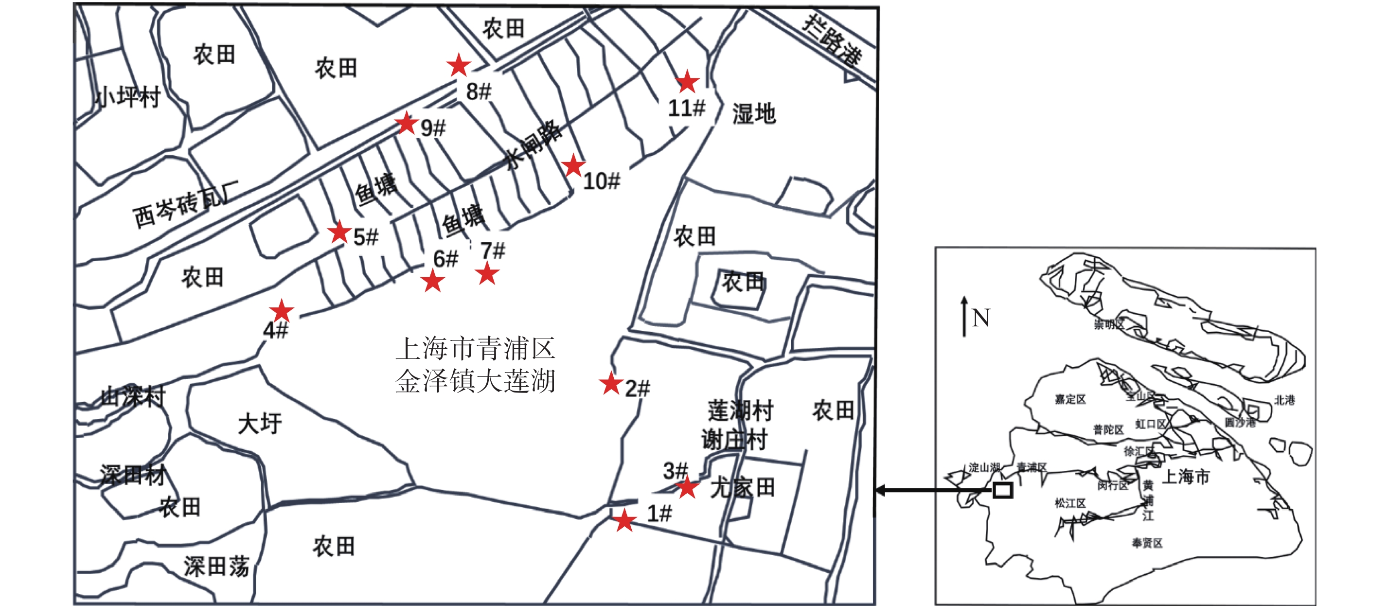
 ), 黄民生1,2,3,4, 汪星5, 王迪芳1,2,4, 查阳1,2,3,4, 李梦茁1,2,3,4, 都皓辰1,2,3,4
 中国综合性科技类核心期刊(北大核心)