 中文核心期刊
华东师范大学学报(自然科学版) ›› 2022, Vol. 2022 ›› Issue (1): 135-147.doi: 10.3969/j.issn.1000-5641.2022.01.015
李嘉皓, 田波*( ), 曹芳, 胡越凯, 段元强, 谢泽昊, 彭亚, 姜文浩, 范惠芳
收稿日期:2020-10-16
出版日期:2022-01-25
发布日期:2022-01-18
通讯作者:
田波
E-mail:btian@sklec.ecnu.edu.cn
基金资助:
Jiahao LI, Bo TIAN*(), Fang CAO, Yuekai HU, Yuanqiang DUAN, Zehao XIE, Ya PENG, Wenhao JIANG, Huifang FAN
Received:2020-10-16
Online:2022-01-25
Published:2022-01-18
Contact:
Bo TIAN
E-mail:btian@sklec.ecnu.edu.cn
摘要:
河口城市受到流域、海洋和局地人类活动的强烈影响, 其水体面临污染和富营养化问题, 对城市生态、生产、生活等造成极大压力. 本项研究针对上海这一特大河口城市的不同水体类型, 利用Sentinel-2遥感影像及水体实测光谱数据, 构建了叶绿素a浓度和浊度两个富营养化的关键水质参量遥感快速反演模型, 并分析了这两个关键参量的时序变化. 结果表明: 基于遥感的叶绿素a浓度、浊度, 反演模型精度良好, 相关系数 (R2) 分别为0.87、0.95, 均方根误差 (RMSE) 分别为4.33 μg/L、8.93 NTU. 2019年时序分析表明, 上海城市水体叶绿素a浓度和浊度均为夏季最高, 冬季最低. 从水体类型上看, 叶绿素a浓度从高到低为: 养殖场/种植塘、永久性淡水湖、库塘、永久性河流、运河/输水河水体, 浊度从高到低为: 养殖场/种植塘、永久性河流、运河/输水河、永久性淡水湖、库塘. 对2019年叶绿素a浓度和浊度的时序变化分析发现, 在人类活动干扰较小的水体中, 叶绿素a浓度和浊度的相关性较强; 而人类活动影响较大的水体中, 两者的相关性较弱. 研究表明, 利用Sentinel-2卫星影像可有效反演城市水体叶绿素a浓度和浊度, 准确跟踪水体富营养化时序变化, 可为其他城市内陆水体的水环境监测提供参考和借鉴.
中图分类号:
李嘉皓, 田波, 曹芳, 胡越凯, 段元强, 谢泽昊, 彭亚, 姜文浩, 范惠芳. 上海城市水体富营养化关键参量的遥感反演与时序分析[J]. 华东师范大学学报(自然科学版), 2022, 2022(1): 135-147.
Jiahao LI, Bo TIAN, Fang CAO, Yuekai HU, Yuanqiang DUAN, Zehao XIE, Ya PENG, Wenhao JIANG, Huifang FAN. Remote sensing inversion and time-series analysis of critical parameters for eutrophication assessment of urban waters in Shanghai[J]. Journal of East China Normal University(Natural Science), 2022, 2022(1): 135-147.
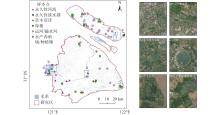
图1
研究区及水体测量点位"
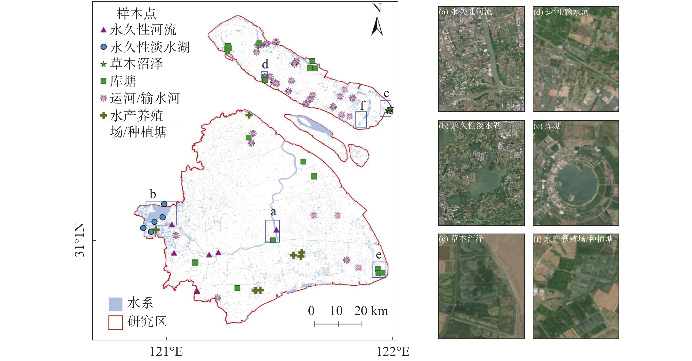
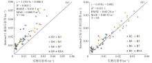
图2
地表实测反射率与Sentinel-2地表反射率之间的关系 (a) 以及原位反射率与太阳反射校正后Sentinel-2地表反射率之间的关系 (b)"
表1
3种水体指数的分类准确性评估"
| 水体指数 | 阈值 | 分类精度 | Kappa 系数 |
| NDWI | –0.2850 | 66.00% | 0.1636 |
| mNDWI | 0.0195 | 98.60% | 0.8814 |
| CIWI | 0.5112 | 60.10% | 0.1289 |
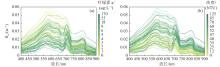
图3
实测遥感反射率 (Rrs) 与Chl-a浓度 (a) 和浊度 (b) 的关系 "
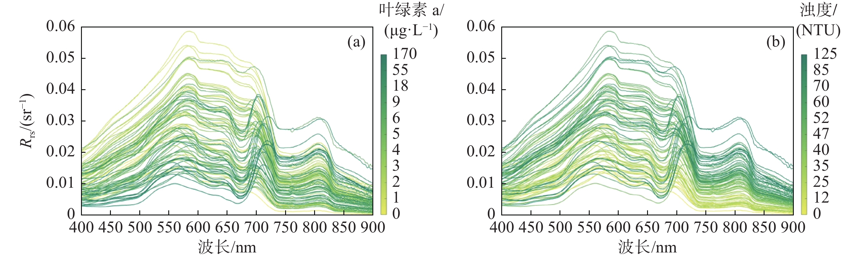
表2
不同的Chl-a浓度反演算法"
| 序号 | 遥感因子 | 方程形式 | 参考模型 |
| 1 | x=Rrs(705)/Rrs(665) | y =3.2998x 3.8235 | Neil等[ |
| 2 | x= Rrs(705)/Rrs(665) | y=56.183x– 49.535 | Gilerson等[ |
| 3 | x= (Rrs(705)–Rrs(665))/ (Rrs(705) + Rrs(665)) | y=308.23x 2 + 78.224x + 4.6854 | Mishra等[ |
| 4 | Rrs(705)、Rrs(740)、Rrs(783)、Rrs(842) | 多元线性回归 | Maeda等[ |
| 5 | x=R–1rs(740)·(R–1rs(665)–R–1rs (705)) | y= 72.632x + 4.9605 | Dall等[ |

图4
实测点与建模点Chl-a浓度对比"
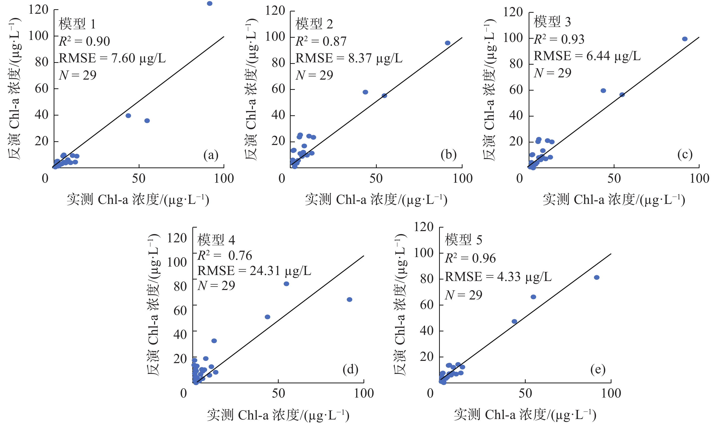

图5
基于Sentinel-2卫星数据的Chl-a浓度(a)和浊度(b)的反演算法验证"
表3
不同的浊度反演算法"
| 序号 | 遥感因子 | 方程形式 | 参考模型 |
| 1 | x = Rrs(665)/Rrs(490) | y = 2.5797e(2.1653x) | Kratzer等[ |
| 2 | x =Rrs(665)/Rrs(560) | y = 401.25x 2–579.43x + 240.59 | Hou等[ |
| 3 | x =Rrs(842)/Rrs(665) | y=62.167x0.65 | Doxaran等[ |
| 4 | x =Rrs(842) | y = –117312 x 2 + 7073x – 9.1356 | Petus等[ |
| 5 | Rrs(665)、Rrs(705)、Rrs(740)、Rrs(783)、Rrs(865) | 多元线性回归 | Maeda等[ |
| 6 | x = Rrs(783) | y = 4904.6x 1.0668 | 本文的方法 |
图6
实测点与建模点浊度对比"
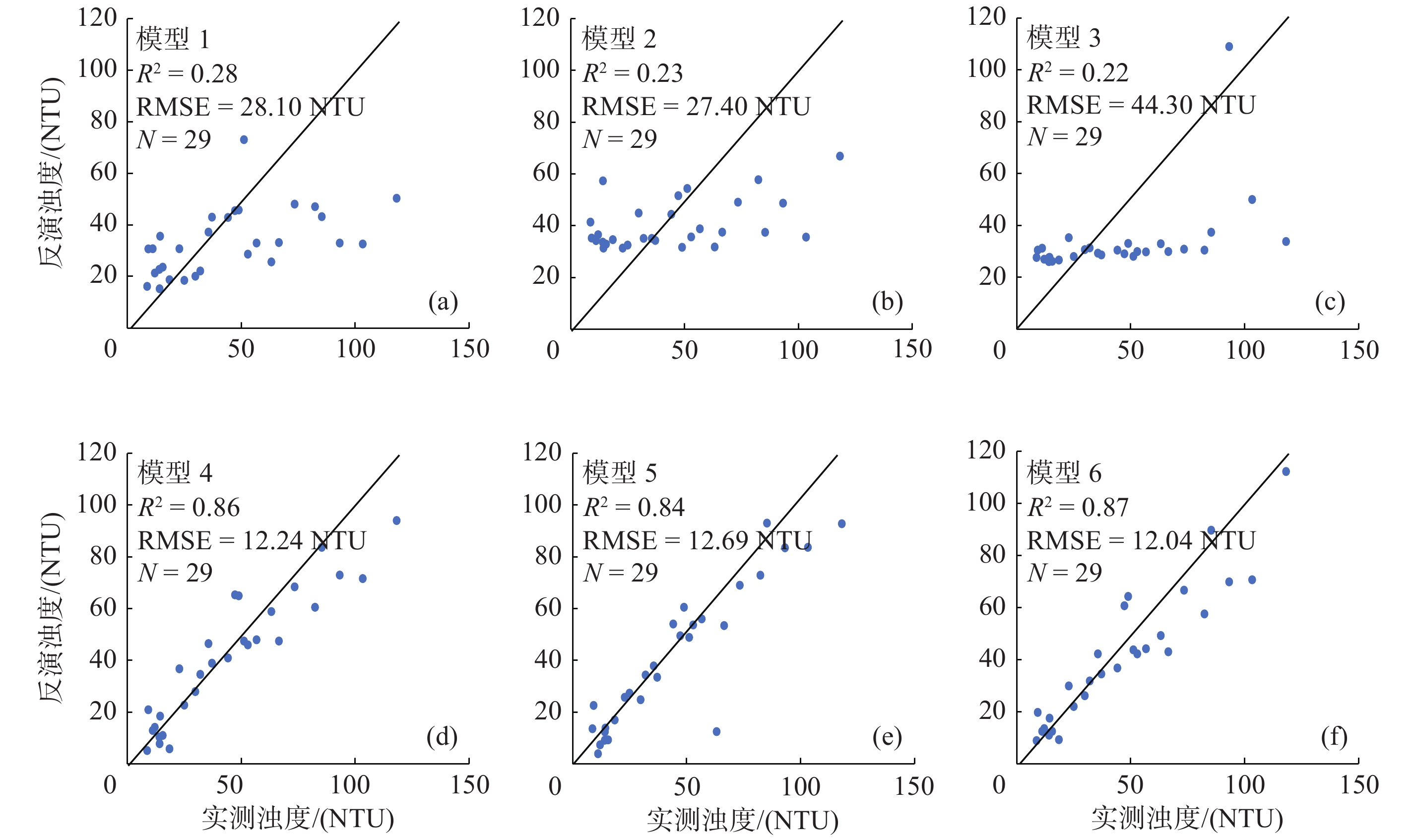
图7
2019年度平均Chl-a浓度和浊度分布"

图8
上海内陆水体Chl-a浓度反演结果 注: (a) 为淀山湖, (b) 为滴水湖, (c) 为崇明养殖塘, (d) 为黄浦江."
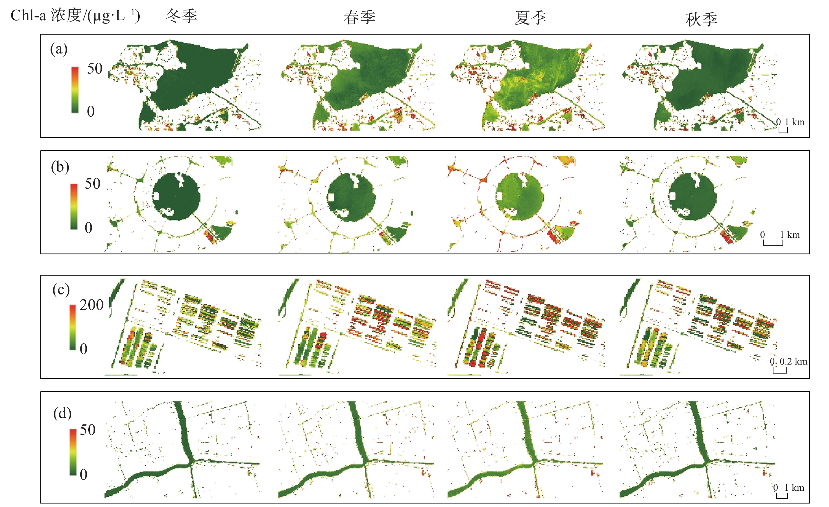
图9
上海内陆水体浊度反演结果 注: (a) 为淀山湖, (b) 为滴水湖, (c) 为崇明养殖塘, (d) 为黄浦江."

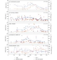
图10
2019年不同水体Chl-a浓度和浊度的时间序列变化关系"

| 1 |
HOU X, FENG L, DUAN H, et al. Fifteen-year monitoring of the turbidity dynamics in large lakes and reservoirs in the middle and lower basin of the Yangtze River, China. Remote Sensing of Environment, 2017, 190, 107- 121.
doi: 10.1016/j.rse.2016.12.006 |
| 2 |
PAERL H W. Assessing and managing nutrient-enhanced eutrophication in estuarine and coastal waters: Interactive effects of human and climatic perturbations. Ecological Engineering, 2006, 26 (1): 40- 54.
doi: 10.1016/j.ecoleng.2005.09.006 |
| 3 |
ANDERSON D M, GLIBERT P M, BURKHOLDER J M. Harmful algal blooms and eutrophication: Nutrient sources, composition, and consequences. Estuaries, 2002, 25 (4): 704- 726.
doi: 10.1007/BF02804901 |
| 4 | 2017年《中国生态环境状况公报》(摘录三)[J]. 环境保护, 2018, 46(13): 70-74. |
| 5 |
MOSES W J, GITELSON A A, BERDNIKOV S, et al. Estimation of chlorophyll- a concentration in case II waters using MODIS and MERIS data—successes and challenges. Environmental Research Letters, 2009, 4 (4): 45005.
doi: 10.1088/1748-9326/4/4/045005 |
| 6 |
金相灿, 朱萱. 我国主要湖泊和水库水体的营养特征及其变化. 环境科学研究, 1991, (1): 11- 20.
doi: 10.3321/j.issn:1001-6929.1991.01.003 |
| 7 |
SEBASTIÁ-FRASQUET M, AGUILAR-MALDONADO J A, SANTAMARÍA-DEL-ÁNGEL E, et al. Sentinel 2 analysis of turbidity patterns in a coastal lagoon. Remote Sensing, 2019, 11 (24): 2926.
doi: 10.3390/rs11242926 |
| 8 | 段洪涛, 张柏, 宋开山, 等. 查干湖叶绿素a浓度高光谱定量模型研究. 环境科学, 2006, (3): 3503- 3507. |
| 9 |
BILOTTA G S, BRAZIER R E. Understanding the influence of suspended solids on water quality and aquatic biota. Water Research, 2008, 42 (12): 2849- 2861.
doi: 10.1016/j.watres.2008.03.018 |
| 10 |
ERFTEMEIJER P L A, ROBIN LEWIS R R. Environmental impacts of dredging on seagrasses: A review. Marine Pollution Bulletin, 2006, 52 (12): 1553- 1572.
doi: 10.1016/j.marpolbul.2006.09.006 |
| 11 |
YANG Y, YAN B, SHEN W. Assessment of point and nonpoint sources pollution in Songhua River Basin, Northeast China by using revised water quality model. Chinese Geographical Science, 2010, 20 (1): 30- 36.
doi: 10.1007/s11769-010-0030-3 |
| 12 |
GUAN Q, FENG L, HOU X, et al. Eutrophication changes in fifty large lakes on the Yangtze Plain of China derived from MERIS and OLCI observations. Remote Sensing of Environment, 2020, 246, 111890.
doi: 10.1016/j.rse.2020.111890 |
| 13 | 黄启会, 贺中华, 梁虹, 等. 基于高光谱数据的百花湖叶绿素a浓度估算. 环境科学与技术, 2019, 42 (1): 134- 141. |
| 14 |
徐祎凡, 施勇, 李云梅. 基于环境一号卫星高光谱数据的太湖富营养化遥感评价模型. 长江流域资源与环境, 2014, 23 (8): 1111- 1118.
doi: 10.11870/cjlyzyyhj201408010 |
| 15 |
DRUSCH M, DEL BELLO U, CARLIER S, et al. Sentinel-2: ESA's optical high-resolution mission for GMES operational services. Remote Sensing of Environment, 2012, 120, 25- 36.
doi: 10.1016/j.rse.2011.11.026 |
| 16 |
阮仁良. 上海市水资源和水环境的可持续发展. 水资源保护, 2003, (1): 21- 24.
doi: 10.3969/j.issn.1004-6933.2003.01.006 |
| 17 |
TIAN B, ZHOU Y, THOM R M, et al. Detecting wetland changes in Shanghai, China using FORMOSAT and Landsat TM imagery. Journal of Hydrology, 2015, 529, 1- 10.
doi: 10.1016/j.jhydrol.2015.07.007 |
| 18 | 唐军武, 田国良, 汪小勇, 等. 水体光谱测量与分析Ⅰ: 水面以上测量法. 遥感学报, 2004, (1): 37- 44. |
| 19 | MUELLER J L, MOREL A, FROUIN R, et al. Ocean optics protocols for satellite ocean color sensor validation, revision 4. Volume III: Radiometric measurements and data analysis protocols [R]. Goddard Space Flight Space Center, 2003. |
| 20 | RUESCAS A B, PEREIRA-SANDOVAL M, TENJO C, et al. Sentinel-2 atmospheric correction inter-comparison over two lakes in Spain and Peru-Bolivia [C/OL]. [2021-10-08]. https://isp.uv.es/papers/Ruescas16CLEO.pdf. |
| 21 |
SÒRIA-PERPINYÀ X, VICENTE E, URREGO P, et al. Remote sensing of cyanobacterial blooms in a hypertrophic lagoon (Albufera of València, Eastern Iberian Peninsula) using multitemporal Sentinel-2 images. Science of the Total Environment, 2020, 698, 134305.
doi: 10.1016/j.scitotenv.2019.134305 |
| 22 |
HEDLEY J D, HARBORNE A R, MUMBY P J. Technical note: Simple and robust removal of sun glint for mapping shallow-water benthos. International Journal of Remote Sensing, 2005, 26 (10): 2107- 2112.
doi: 10.1080/01431160500034086 |
| 23 | 徐涵秋. 利用改进的归一化差异水体指数(MNDWI)提取水体信息的研究. 遥感学报, 2005, (5): 589- 595. |
| 24 |
MEHMET S, BÜLENT S. Survey over image thresholding techniques and quantitative performance evaluation. Journal of Electronic Imaging, 2004, 13 (1): 146- 165.
doi: 10.1117/1.1631315 |
| 25 | O'REILLY J E , MARITORENA S , SIEGEL D A , et al. Ocean color chlorophyll-a algorithms for SeaWiFS, OC2, and OC4: Version 4 [R]. Seawifs Post Launch Calibration & Validation Analyses, 2000: 9-23. |
| 26 |
GILERSON A A, GITELSON A A, ZHOU J, et al. Algorithms for remote estimation of chlorophyll-a in coastal and inland waters using red and near infrared bands. Opt Express, 2010, 18 (23): 24109- 24125.
doi: 10.1364/OE.18.024109 |
| 27 |
NEIL C, SPYRAKOS E, HUNTER P D, et al. A global approach for chlorophyll-a retrieval across optically complex inland waters based on optical water types. Remote Sensing of Environment, 2019, 229, 159- 178.
doi: 10.1016/j.rse.2019.04.027 |
| 28 |
MAEDA E E, LISBOA F, KAIKKONEN L, et al. Temporal patterns of phytoplankton phenology across high latitude lakes unveiled by long-term time series of satellite data. Remote Sensing of Environment, 2019, 221, 609- 620.
doi: 10.1016/j.rse.2018.12.006 |
| 29 |
MISHRA S, MISHRA D R. Normalized difference chlorophyll index: A novel model for remote estimation of chlorophyll-a concentration in turbid productive waters. Remote Sensing of Environment, 2012, 117, 394- 406.
doi: 10.1016/j.rse.2011.10.016 |
| 30 |
DALL OLMO G, GITELSON A A. Effect of bio-optical parameter variability on the remote estimation of chlorophyll-a concentration in turbid productive waters: Experimental results. Applied Optics, 2005, 44 (3): 412- 422.
doi: 10.1364/AO.44.000412 |
| 31 |
SALAMA M S, VERHOEF W. Two-stream remote sensing model for water quality mapping: 2SeaColor. Remote Sensing of Environment, 2015, 157, 111- 122.
doi: 10.1016/j.rse.2014.07.022 |
| 32 |
PETUS C, CHUST G, GOHIN F, et al. Estimating turbidity and total suspended matter in the Adour River plume (South Bay of Biscay) using MODIS 250-m imagery. Continental Shelf Research, 2010, 30 (5): 379- 392.
doi: 10.1016/j.csr.2009.12.007 |
| 33 |
DOXARAN D, FROIDEFOND J, CASTAING P, et al. Dynamics of the turbidity maximum zone in a macrotidal estuary (the Gironde, France): Observations from field and MODIS satellite data. Estuarine, Coastal and Shelf Science, 2009, 81 (3): 321- 332.
doi: 10.1016/j.ecss.2008.11.013 |
| 34 |
KRATZER S, KYRYLIUK D, EDMAN M, et al. Synergy of satellite, in situ and modelled data for addressing the scarcity of water quality information for eutrophication assessment and monitoring of Swedish Coastal Waters. Remote Sensing, 2019, 11 (17): 2051.
doi: 10.3390/rs11172051 |
| 35 |
BOWERS D G, BRAITHWAITE K M, NIMMO-SMITH W A M, et al. Light scattering by particles suspended in the sea: The role of particle size and density. Continental Shelf Research, 2009, 29 (14): 1748- 1755.
doi: 10.1016/j.csr.2009.06.004 |
| 36 | 赵雷, 廖晓斌, 周真明, 等. 泉州某水库水质季节变化原因及对策探究. 中国给水排水, 2020, 36 (1): 36- 42. |
| 37 | 李志波, 季丽, 李丹丹, 等. 罗非鱼精养池塘水质变化规律和沉积物产污系数研究. 环境科学与技术, 2015, 38 (5): 168- 174. |
| 38 |
VANHELLEMONT Q, RUDDICK K. Atmospheric correction of metre-scale optical satellite data for inland and coastal water applications. Remote Sensing of Environment, 2018, 216, 586- 597.
doi: 10.1016/j.rse.2018.07.015 |
| [1] | 刘利华, 郭雪艳, 达良俊, 李静文. 不同富营养化水平对挺水植物生长及氮磷吸收能力的影响[J]. 华东师范大学学报(自然科学版), 20120, 2012(6): 39-45,72. |
| [2] | 师瑞萍, 李必成, 文春青, 张云飞, 吴倩倩, 秦祥堃. 上海自然博物馆植物标本室模式标本的整理与分析[J]. 华东师范大学学报(自然科学版), 2024, 2024(4): 82-99. |
| [3] | 张勇, 王慧, 朱传华, 周浩, 詹宇, 李灿, 肖逸凡, 杨丽丽, 刘佳奇. 基于机器学习的卫星遥感水质富营养化评价——以合肥市环城河为例[J]. 华东师范大学学报(自然科学版), 2024, 2024(1): 1-8, 112. |
| [4] | 唐倩雯, 李清韵, 刘涛, 陈丹. 上海乡村植物景观中多年生草本应用现状分析[J]. 华东师范大学学报(自然科学版), 2023, 2023(3): 53-63. |
| [5] | 王小玲, 宋坤, 乐莺, 陈静, 姜昊, 张涌嘉, 宫鹤忆, 王子斐, 丁一, 施天慧, 达良俊. 上海环城林带夏季大气污染净化作用及其与林带宽度的关系[J]. 华东师范大学学报(自然科学版), 2021, 2021(3): 128-137. |
| [6] | 李路, 杜小弢. 台风引起的长江口及杭州湾沿岸极值风速分布研究[J]. 华东师范大学学报(自然科学版), 2021, 2021(2): 1-11. |
| [7] | 杨正东, 朱建荣, 宋云平, 顾靖华. 长江口余水位时空变化及其成因[J]. 华东师范大学学报(自然科学版), 2021, 2021(2): 12-20. |
| [8] | 王话翔, 初晓冶, 陈莹, 徐露, 杨凯. 特大城市地表水环境溶解氧时空分布特征探究[J]. 华东师范大学学报(自然科学版), 2020, 2020(6): 154-163. |
| [9] | 张红丽, 尹国宇, 郑艳玲, 高娟, 高灯州, 常永凯, 刘程. 沉积物再悬浮对长江口潮滩上覆水体脱氮过程的影响[J]. 华东师范大学学报(自然科学版), 2020, 2020(3): 78-87. |
| [10] | 周运昌, 何岩, 陈静涵, 黄民生. 城市景观水体石灰控藻效应研究[J]. 华东师范大学学报(自然科学版), 2020, 2020(1): 103-109. |
| [11] | 张煊宜, 施润和. 城市服务设施对房价分布格局的影响力探究[J]. 华东师范大学学报(自然科学版), 2019, 2019(6): 169-178. |
| [12] | 吴珍, 陈睿山. 上海海洋生态系统健康评价方法的比较分析[J]. 华东师范大学学报(自然科学版), 2019, 2019(4): 174-187. |
| [13] | 程锐辉, 范群杰, 汪昱昆, 刘垚燚, 车越. 基于PSR模型的上海地区河网脆弱性探讨[J]. 华东师范大学学报(自然科学版), 2019, 2019(3): 144-154. |
| [14] | 韩玉洁, 孙文, 张文文. 基于分布式测算方法的上海城市森林生态系统服务功能评估[J]. 华东师范大学学报(自然科学版), 2019, 2019(2): 147-155. |
| [15] | 许怡雯, 韩静, 何岩, 黄民生. 内源硫影响污染河湖磷营养盐环境行为的研究进展[J]. 华东师范大学学报(自然科学版), 2018, 2018(6): 74-80. |
| 阅读次数 | ||||||
|
全文 |
|
|||||
|
摘要 |
|
|||||