华东师范大学学报(自然科学版) ›› 2022, Vol. 2022 ›› Issue (3): 109-124.doi: 10.3969/j.issn.1000-5641.2022.03.012

• 河口海岸学 • 上一篇    

2007—2016年北支河势变化对长江口盐水入侵影响数值研究

李志鹏, 朱建荣*()   

  1. 华东师范大学 河口海岸学国家重点实验室, 上海 200241
  • 收稿日期:2021-06-16 接受日期:2021-09-29 出版日期:2022-05-25 发布日期:2022-05-19
  • 通讯作者: 朱建荣 E-mail:jrzhu@sklec.ecnu.edu.cn
  • 基金资助:
    国家自然科学基金(41676083)

Numerical simulation of the North Branch regime change impact on saltwater intrusion in the Yangtze River Estuary from 2007 to 2016

Zhipeng LI, Jianrong ZHU*()   

  1. State Key Laboratory of Estuarine and Coastal Research, East China Normal University, Shanghai 200241, China
  • Received:2021-06-16 Accepted:2021-09-29 Online:2022-05-25 Published:2022-05-19
  • Contact: Jianrong ZHU E-mail:jrzhu@sklec.ecnu.edu.cn

摘要:

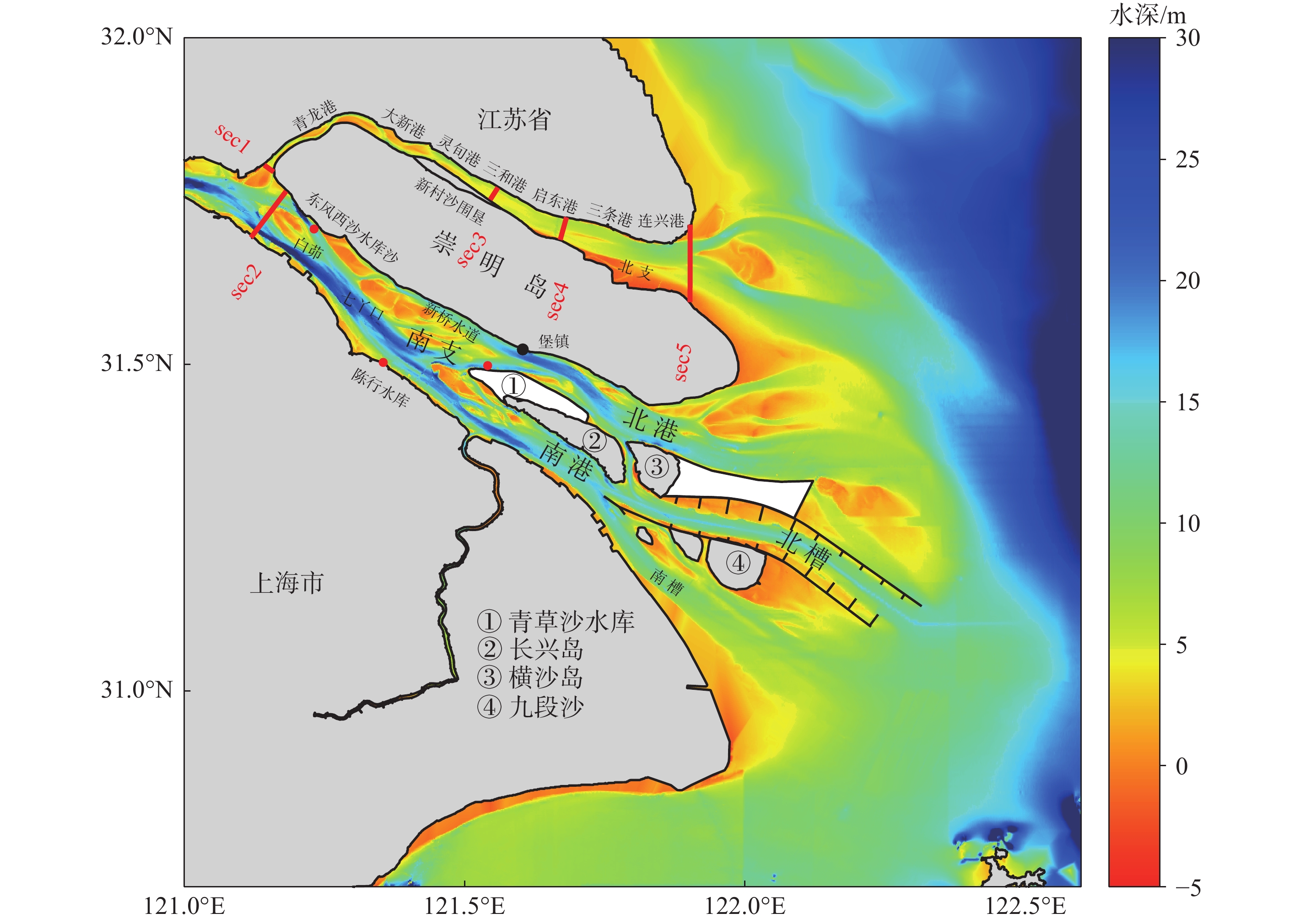
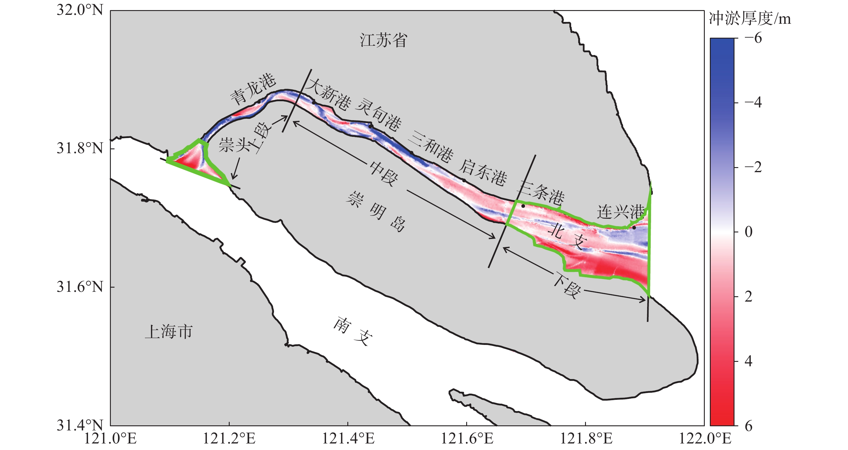
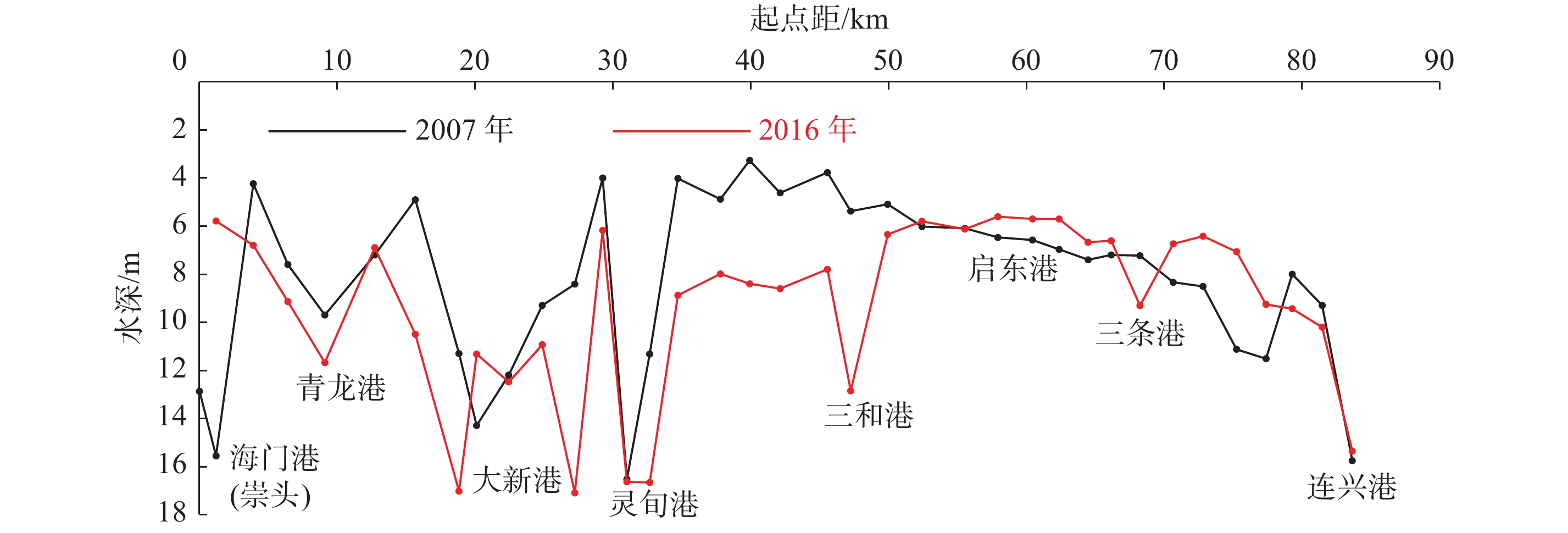
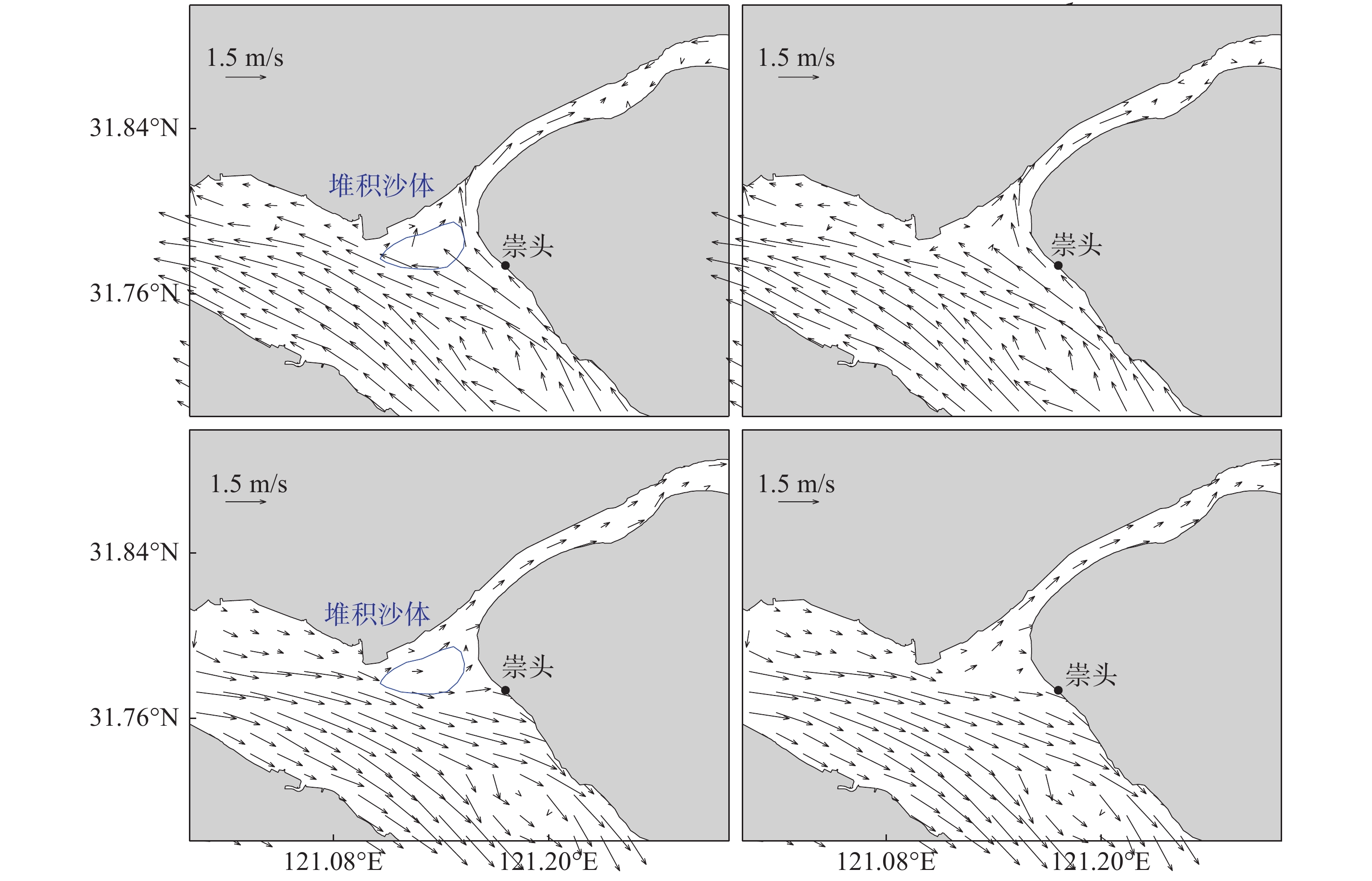
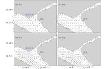
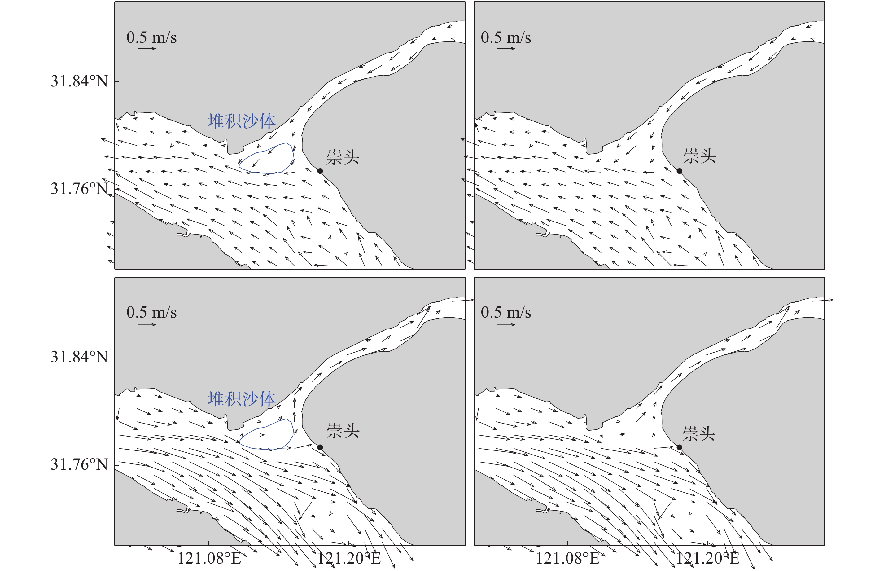
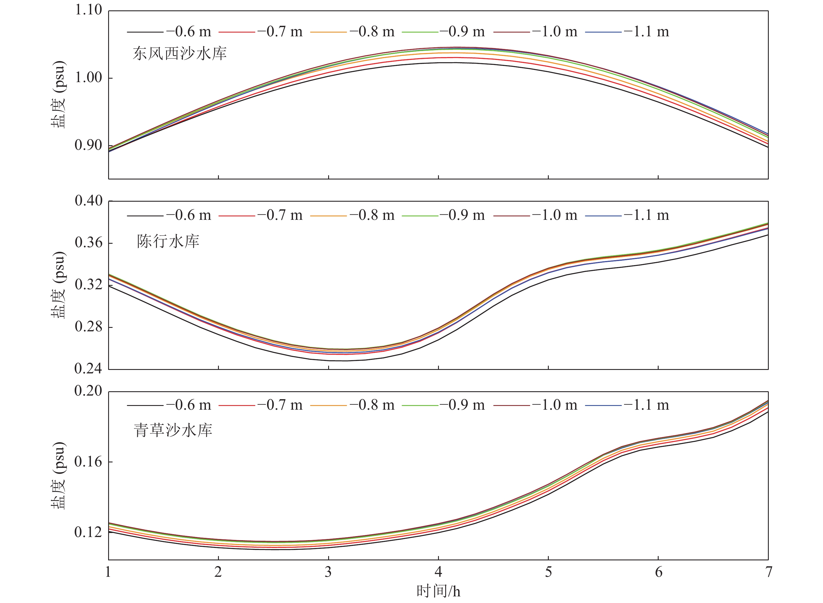
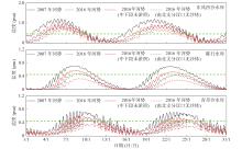
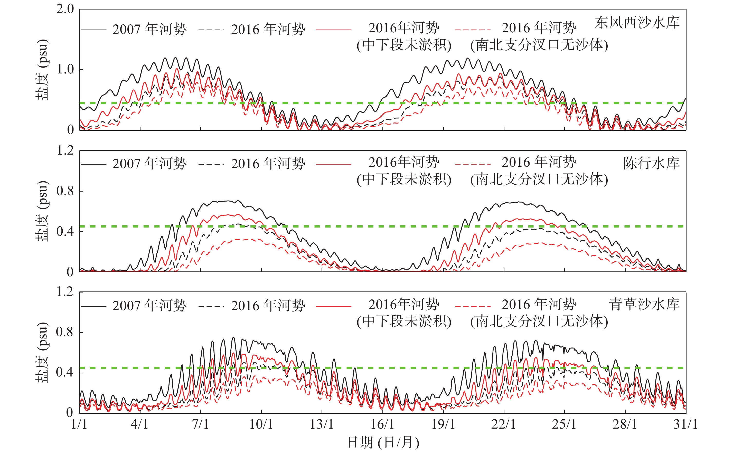
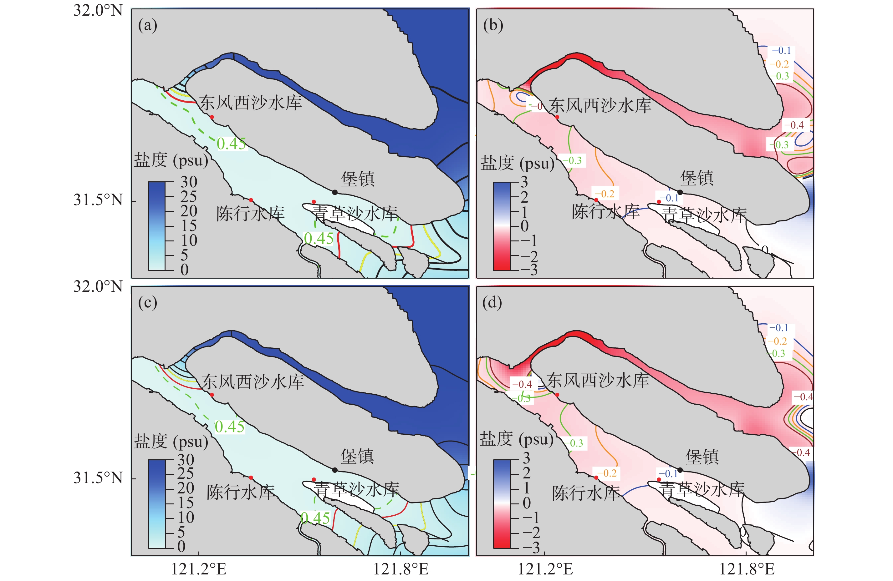
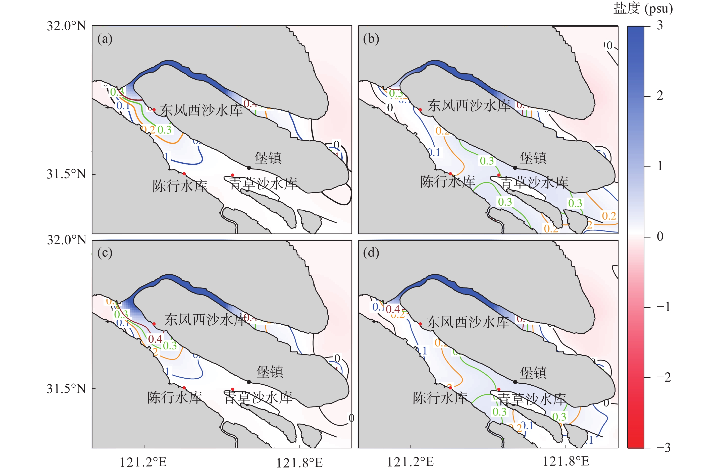
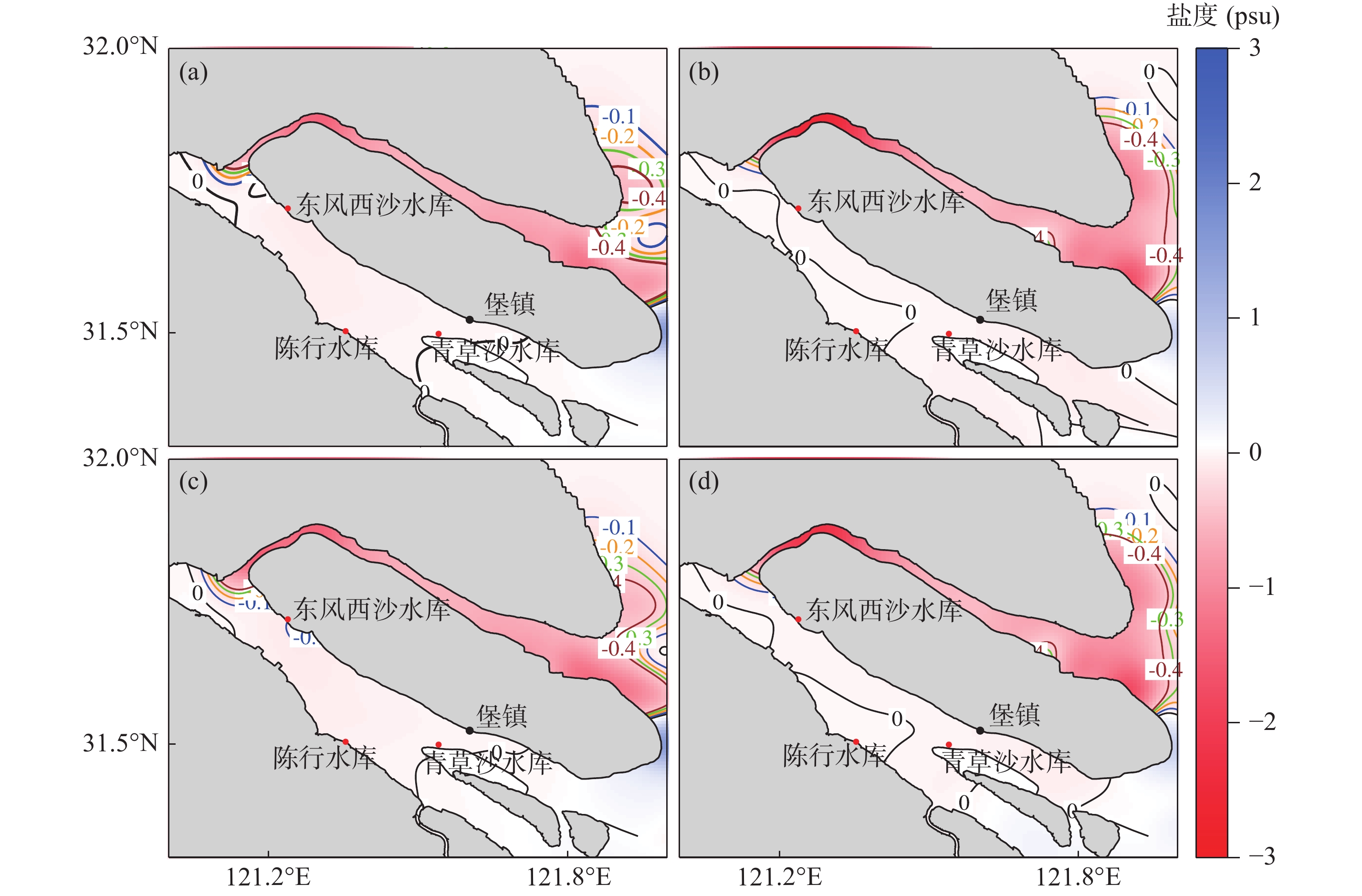
河势变化是影响河口水动力和盐水入侵的一个主要因素. 本文基于长江河口北支2007年和2016年实测水深资料, 分析这10年间北支河势变化, 并数值模拟和分析北支河势变化对水动力和盐水入侵的影响. 2007—2016年河槽容积北支上段增加4.4%, 中段减少8.8%, 下段减少20.5%. 总体上呈现上段冲刷, 中段和下段淤积. 在南北支分汊口出现新生沙体, 淤积厚度达4 ~ 6 m. 数值模拟结果表明: 新生沙体导致大潮期间北支倒灌量增加15.0%, 分流比由–2.8%变化至–3.2%, 新生沙体明显增强了北支盐水倒灌; 新生沙体若继续淤浅0.85 m, 北支盐水倒灌将不再增加; 新生沙体导致南支3个水库取水口盐度增加, 在大潮、大潮后中潮期间, 东风西沙水库取水口平均盐度分别增加了0.14、0.15, 陈行水库取水口分别增加了0.12、0.11, 青草沙水库取水口分别增加了0.11、0.09. 北支下段淤积导致连兴港断面大潮涨落潮量分别减少了15.2%和 16.4%, 小潮涨落潮量分别减少了21.2%和 19.0%; 越往上游, 涨落潮量越少, 呈下降趋势; 北支大潮期间高潮位下降, 低潮位抬升, 潮差减少; 北支中下段纳潮量明显减少, 北支盐水倒灌减弱; 北支下段淤积导致南支3个水库取水口盐度有所降低. 2007—2016年北支河势变化总体上导致北支盐水倒灌明显减弱; 盐度下降在北支上段达到了2 ~ 3, 在下段达到了1 ~ 2; 南支3个水库取水口盐度下降, 在大潮、大潮后中潮期间, 东风西沙水库取水口平均盐度分别降低了0.41、0.21, 陈行水库取水口分别降低了0.34、0.18, 青草沙水库取水口分别降低了0.28、0.17.

关键词: 长江河口, 北支, 河势变化, 盐水入侵, 数值模拟

Abstract:

River regime changes have a substantial impact on estuary hydrodynamics and the incidence of saltwater intrusion. Based on measured water depth data in the North Branch of the Yangtze River Estuary from 2007 and 2016, we analyzed the river regime changes of the North Branch across a 10-year timespan; in addition, we numerically simulated and analyzed the influence of the river regime change on hydrodynamics and saltwater intrusion. The water volume increased by 4.4% in the upstream section, decreased by 8.8% in the midstream, and decreased by 20.5% in the downstream of the North Branch from 2007 to 2016. Overall, the data reflects an overall net erosion in the upstream section and deposition in the midstream and downstream sections of the North Branch. In fact, a new sand body with deposition thickness of 4 ~ 6 m appeared in the bifurcation of the North Brach and South Branch. The numerical simulation results, moreover, show that the new sand body caused a 15.0% increase in saltwater intrusion, a change in net water diversion ratio from –2.8% to –3.2% in the upstream section of the North Branch during spring tide, and clear enhancement of saltwater intrusion; if the new sand body continues to deposit up to 0.85 m, the saltwater intrusion will not increase further. At the water intakes of the three reservoirs in the South Branch, the new sand body caused the average salinity during spring tide to increase by 0.14 at Dongfengxisha reservoir, 0.12 at Chenhang reservoir, and 0.11 at Qingcaosha reservoir; similarly, the average salinity during the subsequent middle tide increased by 0.15 at Dongfengxisha, 0.11 at Chenhang, and 0.09 at Qingcaosha. The deposition in the downstream section of the North Branch led to tidal prisms cross section at the port of Lianxin during flood tide and ebb tide to decrease by 15.2% and 16.4%, respectively, in spring tide, and decrease by 21.2% and 19.0%, respectively, in neap tide. As we move further upstream along the North Branch: the amount of rising and falling tides decreases and shows a relative downward trend, the high tide level drops, the low tide level rises, and the tidal range decreases during spring tide. Moreover, the tidal prisms in the midstream and downstream sections of the North Branch decreased, and the saltwater spillover from the North Branch into the South Branch weakened. The deposition in the downstream section of the North Branch caused the salinity decrease at the water intakes of the three reservoirs of the South Branch. On the whole, the saltwater spillover from the North Branch to the South Branch weakened significantly due to the river regime changes in the North Branch from 2007 to 2016; the salinity decreased by 2 ~ 3 in the upstream section of the North Branch and 1 ~ 2 in the downstream section of the North Branch; the salinity decreased at the water intakes of the three reservoirs of the South Branch; and the average salinity during spring tide and the subsequent middle tide decreased by 0.41 and 0.21, respectively, at Dongfengxisha reservoir, decreased by 0.34 and 0.18, respectively, at Chenhang reservoir, and decreased by 0.28 and 0.17, respectively, at Qingcaosha reservoir.

Key words: the Yangtze River Estuary, North Branch, river regime change, saltwater intrusion, numerical simulation

中图分类号: