| 1 |
BOWDEN K F. Circulation, salinity and river discharge in the Mersey Estuary. Geophysical Journal of the Royal Astronomical Society, 1966, (10): 383- 400.
|
| 2 |
SIMPSON J H, BROWN J, MATTHEWS J, et al. Tidal straining, density currents, and stirring in the control of estuarine stratification. Estuaries, 1990, 13, 125- 132.
doi: 10.2307/1351581
|
| 3 |
GEYER W R. The importance of suppression of turbulence by stratification on the estuarine turbidity maximum[J]. Estuaries and Coasts, 1993, 16: 113-125.
|
| 4 |
MACCREADY P. Toward a unified theory of tidally-averaged estuarine salinity structure. Estuaries, 2004, 27, 561- 570.
doi: 10.1007/BF02907644
|
| 5 |
PRANDLE D. On salinity regimes and the vertical structure of residual flows in narrow tidal estuaries. Estuarine, Coastal and Shelf Science, 1985, 20 (5): 615- 635.
doi: 10.1016/0272-7714(85)90111-8
|
| 6 |
宋志尧, 茅丽华. 长江口盐水入侵研究. 水资源保护, 2002, (3): 27- 30.
|
| 7 |
沈焕庭, 茅志昌, 朱建荣. 长江河口盐水入侵 [M]. 北京: 海洋出版社, 2003: 15-74.
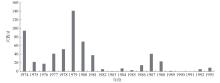
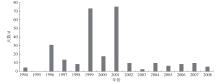
|
| 8 |
罗小峰, 陈志昌. 径流和潮汐对长江口盐水入侵影响数值模拟研究[J]. 海岸工程, 2005, 24(3): 1-6.
|
| 9 |
WU H, ZHU J R, CHEN B R, et al. Quantitative relationship of runoff and tide to saltwater spilling over from the North Branch in the Changjiang Estuary: A numerical study. Estuarine, Coastal and Shelf Science, 2006, 69 (1): 125- 132.
|
| 10 |
朱建荣, 吴辉, 李路, 等. 极端干旱水文年 (2006) 中长江河口的盐水入侵. 华东师范大学学报 (自然科学版), 2010, (4): 1- 6.
|
| 11 |
唐建华, 徐建益, 赵升伟, 等. 基于实测资料的长江河口南支河段盐水入侵规律分析. 长江流域资源与环境, 2011, (6): 677- 684.
|
| 12 |
QIU C, ZHU J R, GU Y L. Impact of seasonal tide variation on saltwater intrusion in the Changjiang River Estuary. Chinese Journal of Oceanology and Limnology, 2012, 30, 342- 351.
doi: 10.1007/s00343-012-1115-x
|
| 13 |
QIU C, ZHU J R. Influence of seasonal runoff regulation by the Three Gorges Reservoir on saltwater intrusion in the Changjiang River Estuary. Continental Shelf Research, 2013, 71, 16- 26.
doi: 10.1016/j.csr.2013.09.024
|
| 14 |
LI L, ZHU J R, WU H. Impacts of wind stress on saltwater intrusion in the Yangtze Estuary. Science China Earth Sciences, 2012, 55 (7): 1178- 1192.
doi: 10.1007/s11430-011-4311-1
|
| 15 |
ARISTIZABAL M F, CHANT R J. An observational study of salt fluxes in Delaware Bay. Journal of Geophysical Research Oceans, 2015, 120, 2751- 2768.
doi: 10.1002/2014JC010680
|
| 16 |
GIDDINGS S N, MACCREADY P. Reverse estuarine circulation due to local and remote wind forcing, enhanced by the presence of along-coast estuaries. Journal of Geophysical Research: Oceans, 2017, 122, 10184- 10205.
doi: 10.1002/2016JC012479
|
| 17 |
ZHU J R, CHENG X Y, LI L J, et al. Dynamic mechanism of an extremely severe saltwater intrusion in the Changjiang Estuary in February 2014. Hydrology and Earth System Sciences, 2020, 24, 5043- 5056.
doi: 10.5194/hess-24-5043-2020
|
| 18 |
AN Q, WU Y Q, TAYLOR S, et al. Influence of the Three Gorges Project on saltwater intrusion in the Yangtze River Estuary. Environmental Geology, 2009, 56 (8): 1679- 1686.
doi: 10.1007/s00254-008-1266-4
|
| 19 |
XU K, ZHU J R, GU Y L. Impact of the eastern water diversion from the south to the north project on the saltwater intrusion in the Changjiang Estuary in China. Acta Oceanologica Sinica, 2012, 31 (3): 47- 58.
doi: 10.1007/s13131-012-0205-0
|
| 20 |
LI L, ZHU J R, WU H, et al. Lateral saltwater intrusion in the North Channel of the Changjiang Estuary. Estuaries and Coasts, 2014, 37 (1): 36- 55.
doi: 10.1007/s12237-013-9669-1
|
| 21 |
陈泾, 朱建荣. 长江河口北支新村沙围垦工程对盐水入侵的影响. 华东师范大学学报 (自然科学版), 2014, (4): 163- 172.
|
| 22 |
李林江, 朱建荣. 长江口南汇边滩围垦工程对流场和盐水入侵的影响. 华东师范大学学报 (自然科学版), 2015, (4): 154- 162.
|
| 23 |
鲍道阳, 朱建荣. 近60年来长江河口河势变化及其对水动力和盐水入侵的影响Ⅲ 盐水入侵. 海洋学报, 2017, 39 (4): 1- 15.
|
| 24 |
丁平兴, 王厚杰, 孟宪伟, 等. 近50年来我国典型海岸带演变过程与原因分析 [M]. 北京: 科学出版社, 2013: 98-106.
|
| 25 |
沈焕庭, 茅志昌, 谷国传, 等. 长江河口盐水入侵的初步研究-兼谈南水北调. 人民长江, 1980, (3): 20- 26.
|
| 26 |
徐建益, 袁建忠. 长江口南支河段盐水入侵规律的研究. 水文, 1994, 83 (5): 1- 6.
|
| 27 |
肖成猷, 沈焕庭. 长江河口盐水入侵影响因子分析. 华东师范大学学报(自然科学版), 1998, (3): 74- 80.
|
| 28 |
LI L, ZHU J R, WU H, et al. A numerical study on the water diversion ratio of the Changjiang Estuary during the dry season. Chinese Journal of Oceanology and Limnology, 2010, 28 (3): 700- 712.
|
| 29 |
WU H, ZHU J R, CHOI B H. Links between saltwater intrusion and subtidal circulation in the Changjiang Estuary: A model-guided study. Continental Shelf Research, 2010, 30, 1891- 1905.
|
| 30 |
韩乃斌. 长江口南支河段氯度变化分析. 水利水运科学研究, 1983, (1): 74- 81.
|
| 31 |
茅志昌, 沈焕庭, 姚运达. 长江口南支南岸水域盐水入侵来源分析. 海洋通报, 1993, 12 (1): 17- 25.
|
| 32 |
肖成猷, 朱建荣, 沈焕庭. 长江口北支盐水倒灌的数值模型研究. 海洋学报, 2000, 22 (5): 124- 132.
|
| 33 |
茅志昌, 沈焕庭, 肖成献. 长江口北支盐水倒灌南支对青草沙水源地的影响. 海洋与湖沼, 2001, 32 (1): 58- 66.
|
| 34 |
顾玉亮, 吴守培, 乐勤. 北支盐水入侵对长江口水源地影响研究. 人民长江, 2003, 34 (4): 1- 3.
|
| 35 |
王国峰, 乐勤. 长江口北支盐水入侵对陈行水库取水口的影响. 城市给排水, 2003, 17 (4): 21- 22.
|
| 36 |
吴辉, 朱建荣. 长江河口北支倒灌盐水输送机制分析. 海洋学报, 2007, 29 (1): 17- 25.
|
| 37 |
陈泾, 朱建荣. 长江河口青草沙水库盐水入侵来源. 海洋学报, 2014, 36, 131- 141.
|
 ), 朱建荣1,*(
 中文核心期刊