| 1 |
TANG J W, YE S F, CHEN X C, et al.. Coastal blue carbon: Concept, study method, and the application to ecological restoration. Science China Earth Sciences, 2018, 61 (6): 637- 646.
|
| 2 |
张峰, 周维芝, 张坤.. 湿地生态系统的服务功益及可持续利用. 地理科学, 2003, 23 (6): 674- 679.
|
| 3 |
GAO S. Chapter 10 - Geomorphology and Sedimentology of Tidal Flats [M]// PERILLO G M E, WOLANSKI E, CAHOON D R, et al. Coastal Wetlands. 2nd ed. [S. l.]: Elsevier, 2019: 359-381.
|
| 4 |
FAN D D, LI C X, WANG D J, et al.. Morphology and sedimentation on open-coast intertidal flats of the Changjiang Delta, China. Journal of Coastal Research, 2004, (s1): 22- 34.
|
| 5 |
任美锷, 张忍顺, 杨巨海, 等.. 风暴潮对淤泥质海岸的影响——以江苏省淤泥质海岸为例. 海洋地质与第四纪地质, 1983, (4): 1- 24.
|
| 6 |
FAN D D, GUO Y X, WANG P, et al.. Cross-shore variations in morphodynamic processes of an open-coast mudflat in the Changjiang Delta, China: With an emphasis on storm impacts. Continental Shelf Research, 2006, 26 (4): 517- 538.
|
| 7 |
SHI B W, YANG S L, TEMMERMAN S, et al.. Effect of typhoon-induced intertidal-flat erosion on dominant macrobenthic species (Meretrix meretrix). Limnology and Oceanography, 2021, 66 (12): 4197- 4209.
|
| 8 |
BARRAS J A.. Land area changes in coastal Louisiana after Hurricanes Katrina and Rita. U. S. Geological Survey Circular, 2007, (1306): 97- 112.
|
| 9 |
KIRWAN M L, MEGONIGAL J P.. Tidal wetland stability in the face of human impacts and sea-level rise. Nature, 2013, 504 (7478): 53- 60.
|
| 10 |
杨世伦, 丁平兴, 赵庆英.. 开敞大河口滩槽冲淤对台风的响应及其动力泥沙机制探讨——以长江口南汇边滩-南槽-九段沙系统为例. 海洋工程杂志, 2002, 20, 69- 75.
|
| 11 |
YANG S L, FRIEDRICHS C T, SHI Z, et al.. Morphological response of tidal marshes, flats and channels of the Outer Yangtze River Mouth to a major storm. Estuaries, 2003, 26 (6): 1416- 1425.
|
| 12 |
杨天. 风暴天气下淤泥质潮滩冲淤过程及其动力机制[D]. 上海: 华东师范大学, 2017.
|
| 13 |
TURNER R E, BAUSTIAN J J, SWENSON E M, et al.. Wetland sedimentation from hurricanes katrina and rita. Science, 2006, 314 (5798): 449- 452.
|
| 14 |
李高如, 龚国宁, 张生乐, 等.. 台风过程影响下的滨海湿地物理变量观测及湿地系统响应. 海洋学报, 2022, 44, 116- 125.
|
| 15 |
XIE W M, HE Q, ZHANG K Q, et al.. Application of terrestrial laser scanner on tidal flat morphology at a typhoon event timescale. Geomorphology, 2017, 292, 47- 58.
|
| 16 |
WESTOBY M J, BRASINGTON J, GLASSER N F, et al.. ‘Structure-from-Motion’ photogrammetry: A low-cost, effective tool for geoscience applications. Geomorphology, 2012, 179, 300- 314.
|
| 17 |
DAI W Q, LI H, ZHOU Z, et al.. UAV Photogrammetry for elevation monitoring of intertidal mudflats. Journal of Coastal Research, 2018, 85 (s1): 236- 240.
|
| 18 |
JAUD M, GRASSO F, LE DANTEC N, et al.. Potential of UAVs for monitoring mudflat morphodynamics (application to the Seine Estuary, France). ISPRS International Journal of Geo-Information, 2016, 5 (4): 50.
|
| 19 |
胡勇, 何旭涛, 徐辉, 等.. RTK无人机在潮间带地形测量中的应用. 地理空间信息, 2021, 19 (4): 41- 43.
|
| 20 |
TURNER I L, HARLEY M D, DRUMMOND C D.. UAVs for coastal surveying. Coastal Engineering, 2016, 114, 19- 24.
|
| 21 |
ZHANG W M, QI J B, WAN P, et al.. An easy-to-use airborne LiDAR data filtering method based on cloth simulation. Remote Sensing, 2016, 8 (6): 501.
|
| 22 |
孟菲. 上海成灾台风的气象特征及灾害风险评估[D]. 上海: 上海海洋大学, 2008.
|
| 23 |
范吉庆. 台风对长江口潮间带湿地沉积动力过程的影响[D]. 上海: 华东师范大学, 2019.
|
| 24 |
宋云平. 东中国海沿岸和长江河口余水位数值模拟[D]. 上海: 华东师范大学, 2021.
|
| 25 |
YANG S L, LI H, YSEBAERT T, et al.. Spatial and temporal variations in sediment grain size in tidal wetlands, Yangtze Delta: On the role of physical and biotic controls. Estuarine, Coastal and Shelf Science, 2008, 77 (4): 657- 671.
|
| 26 |
YANG S L.. Tidal wetland sedimentation in the Yangtze Delta. Journal of Coastal Research, 1999, 15 (4): 1091- 1099.
|
| 27 |
蒋丰佩. 异质潮滩水沙输运研究[D]. 上海: 华东师范大学, 2012.
|
| 28 |
谢卫明. 高浊度河口潮滩动力地貌过程及植被影响研究[D]. 上海: 华东师范大学, 2018.
|
| 29 |
CHEN C P, ZHANG C, SCHWARZ C, et al.. Mapping three-dimensional morphological characteristics of tidal salt-marsh channels using UAV structure-from-motion photogrammetry. Geomorphology, 2022, 407, 108235.
|
| 30 |
孙剑雄. 淤泥质潮间带动力-沉积-地貌环境定量刻画及其生物效应[D]. 上海: 华东师范大学, 2022.
|
| 31 |
MASON D C, DAVENPORT I J, FLATHER R A, et al.. A sensitivity analysis of the waterline method of constructing a digital elevation model for intertidal areas in ERS SAR scene of Eastern England. Estuarine, Coastal and Shelf Science, 2001, 53 (6): 759- 778.
|
| 32 |
王延霞. 顾及典型地理特征的时序InSAR地面沉降监测方法及应用[D]. 北京: 中国矿业大学, 2015.
|
| 33 |
GUARNIERI A, VETTORE A, PIROTTI F, et al.. Retrieval of small-relief marsh morphology from Terrestrial Laser Scanner, optimal spatial filtering, and laser return intensity. Geomorphology, 2009, 113 (1): 12- 20.
|
| 34 |
KIM B O.. Tidal modulation of storm waves on a macrotidal flat in the Yellow Sea. Estuarine, Coastal and Shelf Science, 2003, 57 (3): 411- 420.
|
| 35 |
POSTMA H.. Transport and accumulation of suspended matter in the Dutch Wadden Sea. Netherlands Journal of Sea Research, 1961, 1 (1): 148- 190.
|
| 36 |
高抒, 贾建军, 于谦.. 绿色海堤的沉积地貌与生态系统动力学原理: 研究综述. 热带海洋学报, 2022, 41 (4): 1- 19.
|
| 37 |
游涛. 波浪在斜坡上的传播破碎及沿岸流研究[D]. 天津: 天津大学, 2004.
|
| 38 |
XUE L M, LI X Z, SHI B W, et al.. Pattern-regulated wave attenuation by salt marshes in the Yangtze Estuary, China. Ocean & Coastal Management, 2021, 209, 105686.
|
| 39 |
谢泽昊, 史本伟, 田波, 等.. 盐沼植被缓流能力观测研究——以崇明东滩海三棱藨草盐沼区域为例. 吉林大学学报(地球科学版), 2022, 52, 571- 581.
|
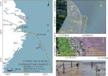
 ), 李天佑1, 彭彪彪1, 李秀珍1, 汪亚平1
 中国综合性科技类核心期刊(北大核心)