 中国综合性科技类核心期刊(北大核心)
Journal of East China Normal University(Natural Science) ›› 2021, Vol. 2021 ›› Issue (4): 121-133.doi: 10.3969/j.issn.1000-5641.2021.04.014
• Geography • Previous Articles Next Articles
Yunping SONG, Jianrong ZHU*( )
)
Received:2020-10-15
Online:2021-07-25
Published:2021-07-23
Contact:
Jianrong ZHU
E-mail:jrzhu@sklec.ecnu.edu.cn
CLC Number:
Yunping SONG, Jianrong ZHU. Numerical simulation and analysis of the spatial and temporal variations in residual water levels of the Changjiang Estuary[J]. Journal of East China Normal University(Natural Science), 2021, 2021(4): 121-133.
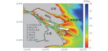
Fig.1
Map of the Changjiang Estuary and the adjacent sea"


Fig.2
Domain and grid of the model (a), enlarged grid near the bifurcation between the North and South Branches (b), and enlarged grid near the Deepwater Navigation Channel project (c)"
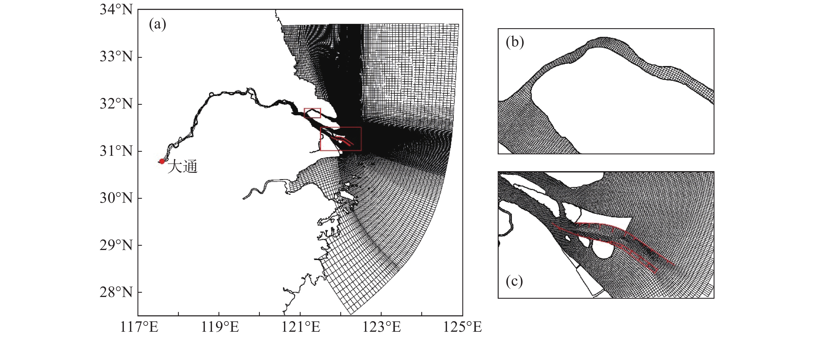
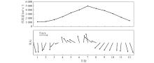
Fig.3
Monthly mean river discharge at Datong station and semi-monthly mean wind vector at Chongming eastern shoal"
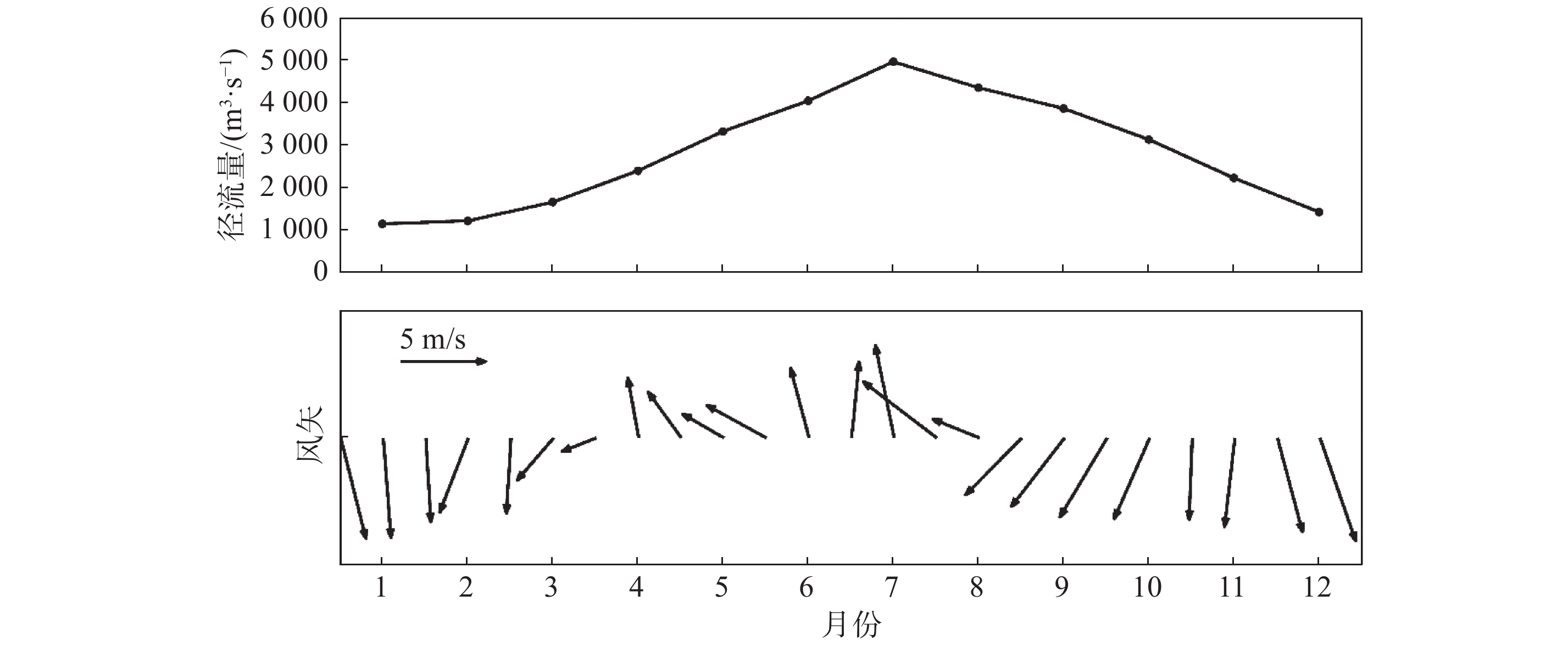
Table 1
Monthly mean river discharge at Datong station between 1950 to 2018"
| 1月 | 2月 | 3月 | 4月 | 5月 | 6月 | 7月 | 8月 | 9月 | 10月 | 11月 | 12月 | |
| 径流量/( × 102 m3·s–1) | 116 | 123 | 167 | 241 | 334 | 406 | 498 | 437 | 388 | 315 | 224 | 144 |
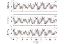
Fig.4
Temporal variation in water levels at Chongxi (a), Nanmen (b), and Baozhen (c) hydrological stations from 0:00 on March 1 to 0:00 March 19, 2018"
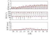
Fig.5
Temporal variations in surface current velocity, speed, and salinity at buoy station A from 12:00 on March 9 to 6:00 on March 19, 2018"

Fig.6
Temporal variations in surface current velocity, speed, and salinity at buoy station B from 12:00 on March 9 to 6:00 on March 19, 2018"


Fig.7
Distribution of monthly mean residual water levels in February (a), May (b), August (c), and November (d)"

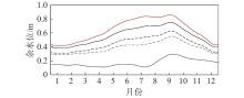
Fig.8
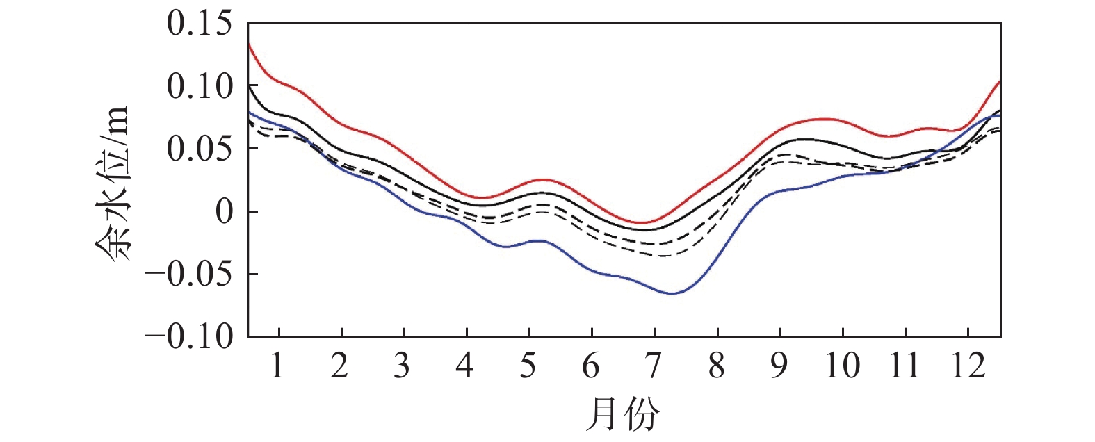
Temporal variations in residual water levels at Chongxi, Nanmen, and Baozhen hydrological stations as well as the Xuliujing model output site and the easternmost section of the northern dike of the Deepwater Navigation Channel"
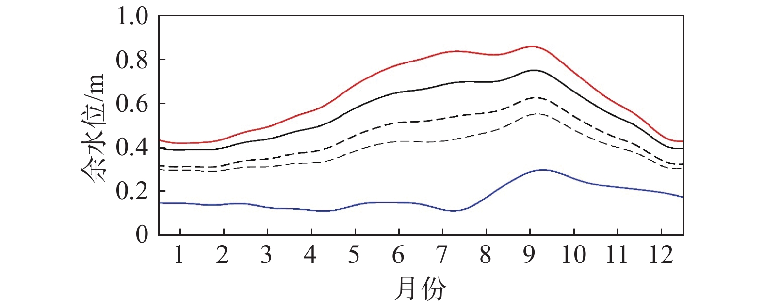

Fig.9
Distribution of monthly mean residual water levels in the Changjiang Estuary in February (a), May (b), August (c), and November (d) in the case of runoff only"
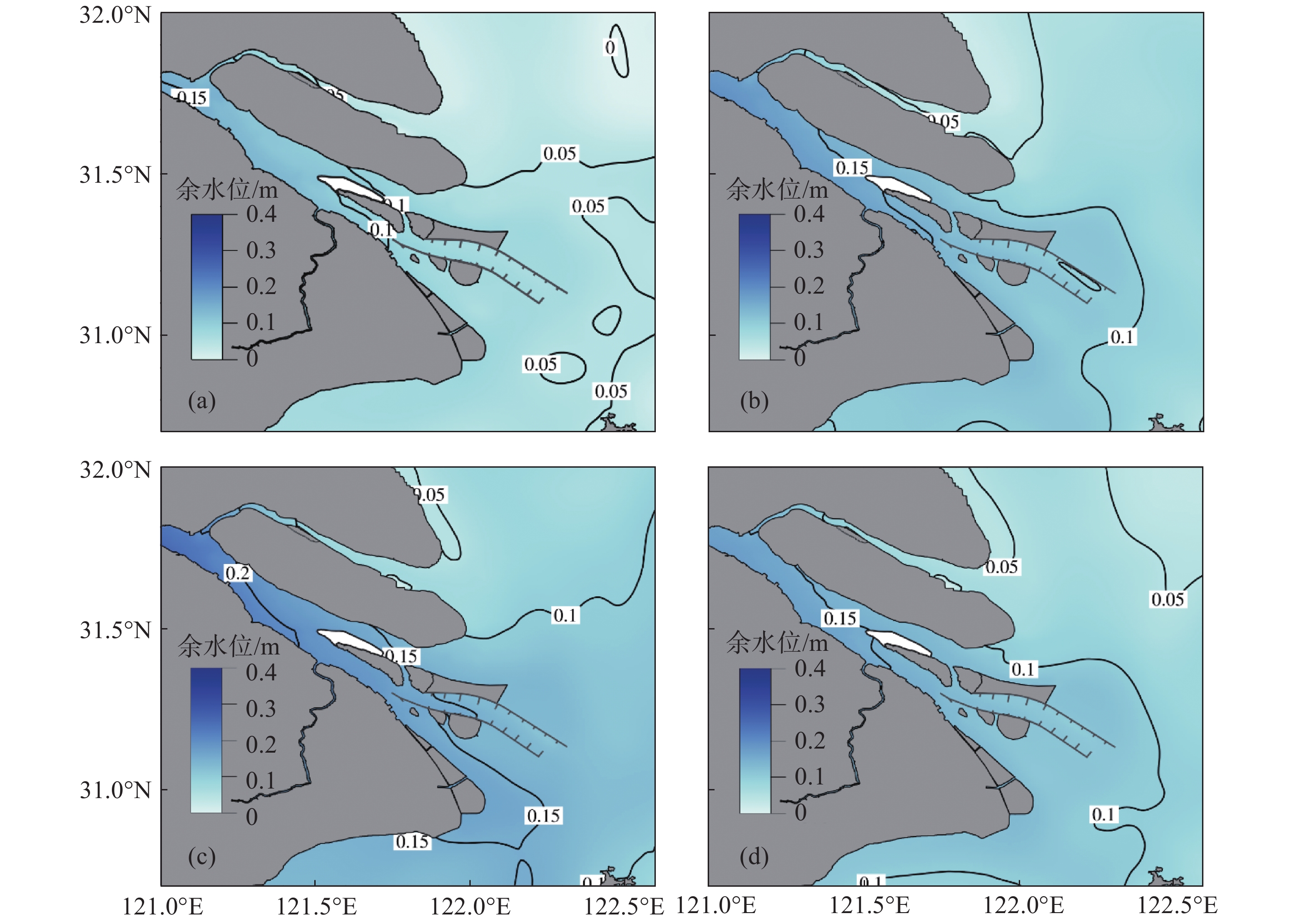
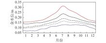
Fig.10
Temporal variation in residual water levels at hydrological stations Chongxi, Nanmen, and Baozhen as well as the Xuliujing model output site and the easternmost section of the northern dike of the Deepwater Navigation Channel in the case of runoff only"
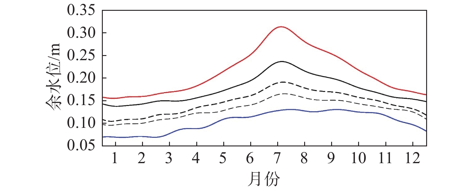

Fig.11
Distribution of monthly mean residual water levels in the Changjiang Estuary in February (a), May (b), August (c), and November (d) in the case of tide only"
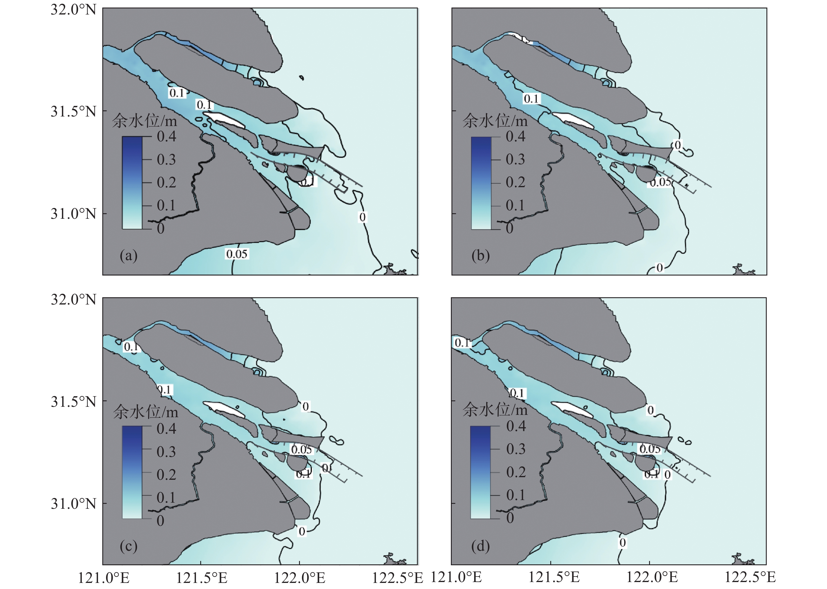
Fig.12
Temporal variations in residual water levels at Chongxi, Nanmen, and Baozhen hydrological stations as well as the Xuliujing model output site and the easternmost section of the northern dike of the Deepwater Navigation Channel in the case of tide only"
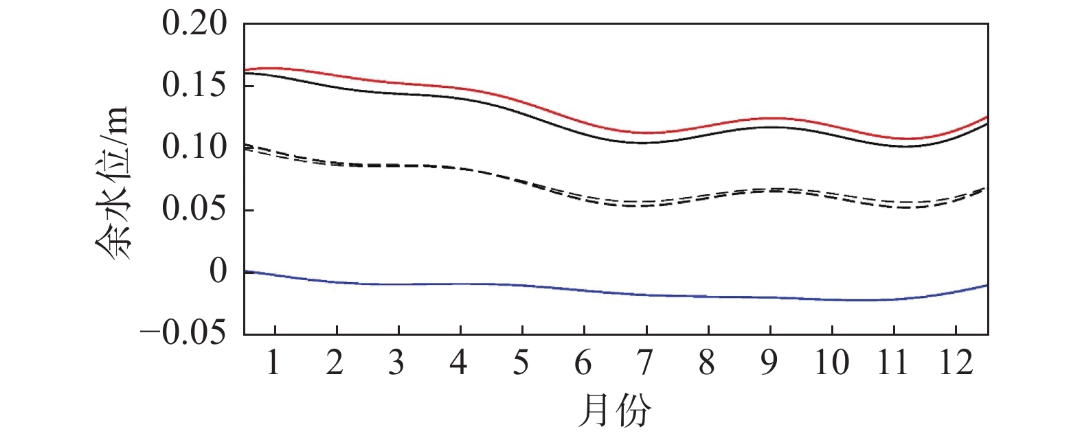

Fig.13
Distribution of monthly mean residual water levels in the Changjiang Estuary in February (a), May (b), August (c), and November (d) in the case of wind only"

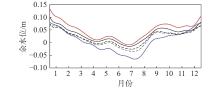
Fig.14
Temporal variations in residual water levels at Chongxi, Nanmen, and Baozhen hydrological stations as well as the Xuliujing model output site and the easternmost section of the northern dike of the Deepwater Navigation Channel in the case of wind only"
| 1 |
王慧, 刘克修, 范文静, 等. 中国沿海增减水的变化特征及与海平面变化的关系. 海洋学报, 2017, 39 (6): 10- 20.
doi: 10.3969/j.issn.0253-4193.2017.06.002 |
| 2 |
裴文斌, 牛桂芝, 董海军. 余水位及潮汐差分方法. 水道港口, 2007, 28 (6): 439- 443.
doi: 10.3969/j.issn.1005-8443.2007.06.012 |
| 3 | 牛桂芝, 董海军, 裴文斌. 余水位的成因及其特性 [C]//第二十一届海洋测绘综合性学术研讨会论文集. 中国测绘学会, 2009. |
| 4 |
FRISON T W. Dynamics of the residuals in estuary water levels. Physics and Chemistry of the Earth, Part B: Hydrology, Oceans and Atmosphere, 2000, 25 (4): 359- 364.
doi: 10.1016/S1464-1909(00)00026-5 |
| 5 | 陈吉余, 沈焕庭, 恽才兴. 长江河口动力过程和地貌演变 [M]. 上海: 上海科学技术出版社, 1988: 31-37. |
| 6 |
WONG K C, GARVINE R W. Observations of wind-induced, subtidal variability in the Delaware estuary. Journal of Geophysical Research: Oceans, 1984, 89 (C6): 10589- 10597.
doi: 10.1029/JC089iC06p10589 |
| 7 |
DENES T A, CAFFREY J M. Changes in seasonal water transport in a Louisiana estuary, Fourleague Bay, Louisiana. Estuaries, 1988, 11 (3): 184- 191.
doi: 10.2307/1351971 |
| 8 |
HESS K. Water level simulation in bays by spatial interpolation of tidal constituents, residual water levels, and datums. Continental Shelf Research, 2003, 23 (5): 395- 414.
doi: 10.1016/S0278-4343(03)00005-0 |
| 9 | BUSCHMAN F A, HOITINK A J F, VAN DER VEGT M, et al. Subtidal water level variation controlled by river flow and tides. Water Resources Research, 2009, 45 (10): W10420. |
| 10 |
SASSI M G, HOITINK A J F. River flow controls on tides and tide-mean water level profiles in a tidal freshwater river. Journal of Geophysical Research: Oceans, 2013, 118 (9): 4139- 4151.
doi: 10.1002/jgrc.20297 |
| 11 | POERBANDONO, HANDOKO E Y, ADYTIA D. Extremes of residual water levels in the West of Java Sea, Indonesia[C]//AIP Conference Proceedings. AIP Publishing LLC, 2018, 1987(1): 020081. |
| 12 |
CAI H, YANG Q, ZHANG Z, et al. Impact of river-tide dynamics on the temporal-spatial distribution of residual water level in the Pearl River channel networks. Estuaries and Coasts, 2018, 41 (7): 1885- 1903.
doi: 10.1007/s12237-018-0399-2 |
| 13 | 蔡华阳, 杨昊, 郭晓娟, 等. 珠江磨刀门河口径潮动力耦合条件下余水位的多时空尺度分析. 海洋学报, 2018, 40 (7): 57- 67. |
| 14 |
洪鹏锋, 杜文印. 强人类活动驱动下珠江磨刀门河口潮汐动力增强原因初探. 人民珠江, 2019, 40 (9): 28- 32.
doi: 10.3969/j.issn.1001-9235.2019.09.005 |
| 15 |
宋永港, 朱建荣, 吴辉. 长江河口北支潮位与潮差的时空变化和机理. 华东师范大学学报(自然科学版), 2011, (6): 10- 19.
doi: 10.3969/j.issn.1000-5641.2011.06.002 |
| 16 |
CAI H, SAVENIJE H H G, GAREL E, et al. Seasonal behaviour of tidal damping and residual water level slope in the Yangtze River estuary: Identifying the critical position and river discharge for maximum tidal damping. Hydrology and Earth System Sciences, 2019, 23 (6): 2779- 2794.
doi: 10.5194/hess-23-2779-2019 |
| 17 | 张先毅, 黄竞争, 杨昊, 等. 长江河口潮波传播机制及阈值效应分析. 海洋与湖沼, 2019, 50 (4): 788- 798. |
| 18 |
黄竞争, 张先毅, 吴峥, 等. 长江感潮河段潮波传播变化特征及影响因素分析. 海洋学报, 2020, 42 (3): 25- 35.
doi: 10.3969/j.issn.0253-4193.2020.03.003 |
| 19 | BLUMBERG A F, MELLOR G L. A description of a three‐dimensional coastal ocean circulation model. Three-dimensional Coastal Ocean Models, 1987, (4): 1- 16. |
| 20 | WU H, ZHU J R, SHEN J, et al. Tidal modulation on the Changjiang River plume in summer. Journal of Geophysical Research: Oceans, 2011, 116 (C8): 192- 197. |
| 21 |
LÜ H, ZHU J R. Impact of the bottom drag coefficient on saltwater intrusion in the extremely shallow estuary. Journal of Hydrology, 2018, 557, 838- 850.
doi: 10.1016/j.jhydrol.2018.01.010 |
| 22 |
LARGE W G, POND S. Open ocean momentum flux measurements in moderate to strong winds. Journal of Physical Oceanography, 1981, 11 (3): 324- 336.
doi: 10.1175/1520-0485(1981)011<0324:OOMFMI>2.0.CO;2 |
| 23 | 海洋图集编委会. 渤海黄海东海海洋图集: 水文 [M]. 北京: 海洋出版社, 1993. |
| 24 |
RALSTON D K, GEYER W R, LERCZAK J A. Subtidal salinity and velocity in the Hudson River estuary: Observations and modeling. Journal of Physical Oceanography, 2008, 38 (4): 753- 770.
doi: 10.1175/2007JPO3808.1 |
| 25 |
LI L, ZHU J R, WU H, et al. A numerical study on water diversion ratio of the Changjiang (Yangtze) estuary in dry season. Chinese Journal of Oceanology and Limnology, 2010, 28 (3): 700- 712.
doi: 10.1007/s00343-010-9114-2 |
| 26 | 朱建荣, 胡松. 河口形状对河口环流和盐水入侵的影响. 华东师范大学学报(自然科学版), 2003, (2): 70- 75. |
| 27 |
CAI H, SAVENIJE H H G, JIANG C. Analytical approach for predicting fresh water discharge in an estuary based on tidal water level observations. Hydrology and Earth System Sciences, 2014, 18 (10): 4153.
doi: 10.5194/hess-18-4153-2014 |
| 28 |
LI L, ZHU J, WU H. Impacts of wind stress on saltwater intrusion in the Yangtze Estuary. Science China Earth Sciences, 2012, 55, 1178- 1192.
doi: 10.1007/s11430-011-4311-1 |
| [1] | CHEN Shi-qian, ZHU Jian-rong. Three-dimensional numerical simulation of the drift and diffusion of oil film at the highway bridge in the Yalu River [J]. Journal of East China Normal University(Natural Sc, 20120, 2012(6): 46-56. |
| [2] | Lu LI, Xiaotao DU. The distribution of peak wind speeds induced by typhoons along the coasts of the Changjiang Estuary and Hangzhou Bay [J]. Journal of East China Normal University(Natural Science), 2021, 2021(2): 1-11. |
| [3] | Yiping ZHU. Analysis of the characteristics of the Qingcaosha Reservoir direct saltwater intrusion from the open sea in the Changjiang Estuary [J]. Journal of East China Normal University(Natural Science), 2021, 2021(2): 21-29. |
| [4] | Can GE, Weiguo ZHANG. Magnetic properties of particle-sized fractions of sediments in the Changjiang Estuary and neighboring shelf, and its environmental implications [J]. Journal of East China Normal University(Natural Science), 2021, 2021(2): 30-41. |
| [5] | Zhengdong YANG, Jianrong ZHU, Yunping SONG, Jinghua GU. Spatial and temporal variations in the residual water level of the Changjiang Estuary and its cause [J]. Journal of East China Normal University(Natural Science), 2021, 2021(2): 12-20. |
| [6] | LU Jiayu, GE Jianzhong, DING Pingxing. A discussion on the diversion process of tide-dominated estuary bifurcation: The North Branch estuary of the Yangtze River [J]. Journal of East China Normal University(Natural Science), 2020, 2020(3): 1-12. |
| [7] | ZHU Jianrong, LU Peiyi, TANG Chuanmin, CHEN Qing, Lü Hanghang. Numerical simulation of saltwater intrusion mitigation by building a sluice in the North Branch of the Changjiang Estuary [J]. Journal of East China Normal University(Natural Science), 2020, 2020(3): 13-22. |
| [8] | TANG Chuanmin, ZHU Jianrong. Influence of water level rise on currents and saltwater intrusion in the Changjiang Estuary [J]. Journal of East China Normal University(Natural Science), 2020, 2020(3): 23-31. |
| [9] | SU Aiping, Lü Hanghang, WU Yufan. Impact of the South-to-North Water Diversion Project on saltwater intrusion and freshwater resources in the Changjiang Estuary [J]. Journal of East China Normal University(Natural Science), 2020, 2020(3): 32-42. |
| [10] | FEI Bei-li, XIE Li-na, LI Shi-hua, CHEN Wei, GE Zhen-ming. Variations in organic carbon and its impact on tidal creeks within vegetation communities in the coastal wetlands of the Yangtze Estuary [J]. Journal of East China Normal University(Natural Sc, 2019, 2019(1): 156-165. |
| [11] | ZHU Ping, WU Hui. Water mass transport and its controlling mechanisms between the Changjiang Estuary and Subei Coastal Water during the summer [J]. Journal of East China Normal University(Natural Sc, 2018, 2018(4): 171-183. |
| [12] | BAI Mei, WU Hui. Characteristics of sea surface temperature in the Changjiang Estuary and adjacent waters based on a Self-Organizing Map [J]. Journal of East China Normal University(Natural Sc, 2018, 2018(4): 184-194. |
| [13] | LI Min-xi, MAO Jia-li, YUAN Pei-sen, JIN Che-qing. Detection of fake plate vehicles based on traffic data stream [J]. Journal of East China Normal University(Natural Sc, 2018, 2018(2): 63-76,100. |
| [14] | LI Guo-ping, ZHU Jian-rong. Analyses of saltwater intrusion at the water intake of Qingcaosha reservoir in the Changjiang Estuary in dry season from 2015 to 2017 [J]. Journal of East China Normal University(Natural Sc, 2018, 2018(2): 160-169. |
| [15] | YANG Wan-lun, DAO Fu-hai, LUAN Hua-long, GE Jian-zhong, DING Ping-xing. Study of the ebb sediment diversion ratios during wet season in the South and North Passage, Changjiang Estuary [J]. Journal of East China Normal University(Natural Sc, 2018, 2018(2): 170-180. |
| Viewed | ||||||
|
Full text |
|
|||||
|
Abstract |
|
|||||