 中国综合性科技类核心期刊(北大核心)
Journal of East China Normal University(Natural Science) ›› 2023, Vol. 2023 ›› Issue (3): 181-193.doi: 10.3969/j.issn.1000-5641.2023.03.018
• Estuary and Coastal Research • Previous Articles
Xiaoting WANG1( ), Hualong LUAN2, Weiguo ZHANG1,*(), Nina Siu-Ngan LAM3
Received:2021-11-02
Accepted:2022-01-06
Online:2023-05-25
Published:2023-05-25
Contact:
Weiguo ZHANG
E-mail:xiaotingwang_1@163.com;wgzhang@sklec.ecnu.edu.cn
CLC Number:
Xiaoting WANG, Hualong LUAN, Weiguo ZHANG, Nina Siu-Ngan LAM. Assessment of land use exposure to coastal erosion in the delta region and its implications on spatial planning: An example from the Pudong New Area of Shanghai[J]. Journal of East China Normal University(Natural Science), 2023, 2023(3): 181-193.
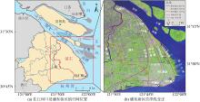
Fig.1
Map showing the Yangtze Estuary and Pudong New Area of Shanghai and the historical coastline changes of the Pudong New Area"

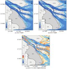
Fig.2
Bathymetric maps in 2016 and 2035 of coastal areas along the Pudong New Area and bathymetric changes between 2016 and 2035"

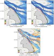
Fig.3
Distribution of erosion vulnerability class in coastal areas along the Pudong New Area in 2016 and 2035 and changes between 2016 and 2035"

Table 1
Distribution of erosion vulnerability class in coastal areas along the Pudong New Area in 2016 and 2035 and relative changes"
| 脆弱性等级 | 2016 年长度/km | 2016 年比例/% | 2035 年长度/km | 2035 年比例/% | 2016—2035 年比例增减/% |
| 极低 | 22.28 | 21.47 | 29.57 | 28.50 | 7.02 |
| 低 | 8.49 | 8.18 | 6.80 | 6.55 | –1.63 |
| 中等 | 40.52 | 39.04 | 17.90 | 17.24 | –21.80 |
| 高 | 22.31 | 21.50 | 27.16 | 26.18 | 4.67 |
| 极高 | 10.17 | 9.80 | 22.35 | 21.53 | 11.73 |
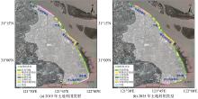
Fig.4
Distribution of land use types in coastal areas along the Pudong New Area in 2019 and 2035"
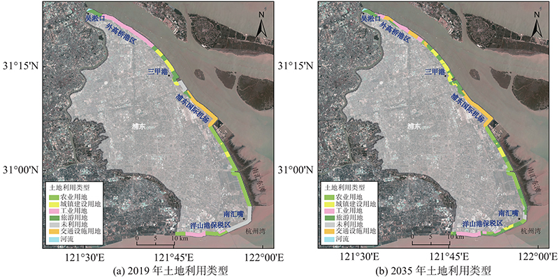

Fig.5
Distribution of the class of land use value in coastal areas along the Pudong New Area in 2019 and 2035 and changes between 2019 and 2035"
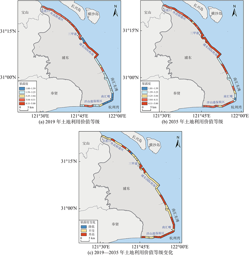
Table 2
Distribution of the class of land use value in coastal areas along the Pudong New Area in 2019 and 2035 and its relative change"
| 暴露性等级 | 2019 年长度/km | 2019 年比例/% | 2035 年长度/km | 2035 年比例/% | 2019—2035 年比例增减/% |
| 极低 | 15.41 | 14.85 | 1.30 | 1.25 | –13.60 |
| 低 | 29.78 | 28.69 | 20.31 | 19.57 | –9.13 |
| 中等 | 3.62 | 3.48 | 5.96 | 5.74 | 2.26 |
| 高 | 35.01 | 33.73 | 34.63 | 33.37 | –0.36 |
| 极高 | 19.97 | 19.24 | 41.59 | 40.07 | 20.83 |
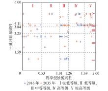
Fig.6
Bi-plot of classes of erosion vulnerability and land use value exposure in coastal areas along the Pudong New Area in 2016 and 2035"

| 1 | SYVITSKI J, KETTNER A J, OVEREEM I, et al. Sinking deltas due to human activities. Nature Geoscience, 2009, 2 (10): 681- 686. |
| 2 | TESSLER Z D, VÖRÖSMARTY C J, GROSSBERG M, et al. Profiling risk and sustainability in coastal deltas of the world. Science, 2015, 349 (6248): 638- 643. |
| 3 | SZABO S, BRONDIZIO E, RENAUD F G, et al. Population dynamics, delta vulnerability and environmental change: Comparison of the Mekong, Ganges-Brahmaputra and Amazon delta regions. Sustainability Science, 2016, 11 (4): 539- 554. |
| 4 | LAM N S N, XU Y, LIU K-B, et al. Understanding the Mississippi River Delta as a coupled natural-human system: Research methods, challenges, and prospects. Water, 2018, 10 (8): 1054. |
| 5 | ANDERSON C C, HAGENLOCHER M, RENAUD F G, et al. Comparing index-based vulnerability assessments in the Mississippi Delta: Implications of contrasting theories, indicators, and aggregation methodologies. International Journal of Disaster Risk Reduction, 2019, 39, 101- 128. |
| 6 | 刘曦, 沈芳. 长江三角洲海岸侵蚀脆弱性模糊综合评价. 长江流域资源与环境, 2010, (S1): 199- 203. |
| 7 | 刘小喜, 陈沈良, 蒋超, 等. 苏北废黄河三角洲海岸侵蚀脆弱性评估. 地理学报, 2014, 69 (5): 607- 718. |
| 8 | LI X, ZHOU Y X, TIAN B, et al. GIS-based methodology for erosion risk assessment of the muddy coast in the Yangtze Delta. Ocean and Coastal Management, 2015, 108, 97- 108. |
| 9 | ISLAM A M, DEBASHIS M, ASHRAF D, et al. Coastal multi-hazard vulnerability assessment along the Ganges deltaic coast of Bangladesh - A geospatial approach. Ocean and Coastal Management, 2016, 127, 1- 15. |
| 10 | MOHAMED S A. Coastal vulnerability assessment using GIS-Based multicriteria analysis of Alexandria-northwestern Nile Delta. Journal of African Earth Science, 2020, 163, 103751. |
| 11 | WANG X T, ZHANG W G, YIN J, et al. Assessment of coastal erosion vulnerability and socio-economic impact along the Yangtze River Delta. Ocean and Coastal Management, 2021, 215, 105953. |
| 12 | FITTON J M, HANSOM J D, RENNIE A F. A method for modelling coastal erosion risk: The example of Scotland. Natural Hazards, 2018, 91 (3): 931- 961. |
| 13 | DASTGHEIB A, JONGEJAN R, WICKRAMANAYAKE M, et al. Regional scale risk-informed land-use planning using probabilistic coastline recession modelling and economical optimisation: East coast of Sri Lanka. Journal of Marine Science and Engineering, 2018, 6 (4): 120. |
| 14 | CLAUDIA W, VAFEIDIS A T, DANIEL L, et al. Effects of scale and input data on assessing the future impacts of coastal flooding: An application of DIVA for the Emilia-Romagna coast. Frontiers in Marine Science, 2016, 3 (32): 1- 15. |
| 15 | HINKEL J, FEYEN L, HEMER M, et al. Uncertainty and bias in global to regional scale assessments of current and future coastal flood risk. Earth’s Future, 2021, 9 (7): 1- 28. |
| 16 | LUO S L, WANG H, CAI F. An integrated risk assessment of coastal erosion based on fuzzy set theory along Fujian coast, southeast China. Ocean and Coastal Management, 2013, 84, 68- 76. |
| 17 | ROY S, PANDIT S, PAPIA M, et al. Coastal erosion risk assessment in the dynamic estuary: The Meghna estuary case of Bangladesh coast. International Journal of Disaster Risk Reduction, 2021, 61 (2): 102364. |
| 18 | LIQUETE C, ZULIAN G, DELGADO I, et al. Assessment of coastal protection as an ecosystem service in Europe. Ecological Indicators, 2013, 30, 205- 217. |
| 19 | MUIR F M E, HURST M D, RENNIE A F, et al. Dynamic coast: National coast erosion risk assessment, CRW2017_08[R]. England: Scotland’s Centre of Expertise for Waters (CREW), 2021. |
| 20 | 上海市人民政府. 南汇新城“十四五”规划建设行动方案 [R]. 上海: 上海市人民政府, 2021. |
| 21 | LUAN H L, DING P X, WANG Z B, et al. Decadal morphological evolution of the Yangtze Estuary in response to river input changes and estuarine engineering projects. Geomorphology, 2016, 265, 12- 23. |
| 22 | ZHAO J, GUO L C, HE Q, et al. An analysis on half century morphological changes in the Changjiang Estuary: Spatial variability under natural processes and human intervention. Journal of Marine Systems, 2018, 181, 25- 36. |
| 23 | ZHU C Y, GUO L C, VAN MAREN D S, et al. Decadal morphological evolution of the mouth zone of the Yangtze Estuary in response to human interventions. Earth Surface Processes and Landforms, 2019, 44, 2319- 2332. |
| 24 | LUAN H L, DING P X, YANG S L, et al. Accretion-erosion conversion in the subaqueous Yangtze delta in response to fluvial sediment decline. Geomorphology, 2021, 382 (4): 107680. |
| 25 | 陈吉余, 沈焕庭, 恽才兴, 等. 长江河口动力过程和地貌演变 [M]. 上海: 上海科学技术出版社, 1988. |
| 26 | 陈沈良, 张国安, 谷国传. 长江口南汇边滩的演变及其沉积动力机制. 上海地质, 2003, (4): 1- 4. |
| 27 | 袁志伦. 上海海塘修筑史略. 上海水务, 1986, (2): 3- 12. |
| 28 | 张修桂. 上海浦东地区成陆过程辨析. 地理学报, 1998, 53 (3): 228- 237. |
| 29 | 栾华龙. 长江河口年代际冲淤演变预测模型的建立及应用 [D]. 上海: 华东师范大学, 2017. |
| 30 | 水利部长江水利委员会. 长江泥沙公报2020 [M]. 武汉: 长江出版社, 2021. |
| 31 | YANG S L, LIU Z, DAI S B, et al. Temporal variations in water resources in the Yangtze River (Changjiang) over the Industrial Period based on reconstruction of missing monthly discharges. Water Resources Research, 2010, 46 (10): W10516. |
| 32 | YANG S L, MILLIMAN J D, XU K H, et al. Downstream sedimentary and geomorphic impacts of the Three Gorges Dam on the Yangtze River. Earth-Science Reviews, 2014, 138, 469- 486. |
| 33 | WANG J, GAO W, XU S, et al. Evaluation of the combined risk of sea level rise, land subsidence, and storm surges on the coastal areas of Shanghai, China. Climatic Change, 2012, 115 (3/4): 537- 558. |
| 34 | 自然资源部海洋预警监测司. 2018年中国海平面公报 [M/OL][2019-04-28]. http://gi.mnr.gov.cn/201905/t20190510_2411195.html. |
| 35 | WANG S Y, LIU J S, YANG C J. Eco-environmental vulnerability evaluation in the Yellow River Basin, China. Pedosphere, 2008, 18 (2): 171- 182. |
| 36 | 冯小铭, 韩子章, 黄家柱. 南通地区江海岸线近40年之变迁——江海岸的侵蚀和淤积. 海洋地质与第四纪地质, 1992, (2): 67- 79. |
| 37 | 中华人民共和国住房和城乡建设部. 建筑结构可靠性设计统一标准: GB 50068—2018 [S]. 北京: 中国建筑科学研究院有限公司, 2018. |
| 38 | 中华人民共和国住房和城乡建设部. 城市用地分类与规划建设用地标准: GB 50137—2011 [S]. 北京: 中国建筑工业出版社, 2012. |
| 39 | WARD P J, MARFAI M A, YULIANTO F, et al. Coastal inundation and damage exposure estimation: A case study for Jakarta. Natural Hazards, 2010, 56 (3): 899- 916. |
| 40 | ARMSTRONG S B, LAZARUS E D. Reconstructing patterns of coastal risk in space and time along the US Atlantic coast, 1970–2016. Natural Hazards and Earth System Sciences, 2019, 19 (11): 2497- 2511. |
| 41 | AUCELLI P, PAOLA G D, RIZZO A, et al. Present day and future scenarios of coastal erosion and flooding processes along the Italian Adriatic coast: The case of Molise region. Environmental Earth Sciences, 2018, 77 (10): 371. |
| 42 | YIN J, YIN Z E, WANG J. National assessment of coastal vulnerability to sea-level rise for the Chinese coast. Journal of Coastal Conservation, 2012, 16 (1): 123- 133. |
| 43 | 上海市浦东新区人民政府, 上海市规划与自然资源局. 上海市浦东新区国土空间总体规划(2017—2035) [R]. 上海: 上海市规划与自然资源局, 2019. |
| 44 | 陈吉余, 恽才兴, 徐海根, 等. 两千年来长江河口发育的模式 [J]. 海洋学报, 1979(1): 103-111. |
| 45 | 李九发. 长江河口南汇潮滩泥沙输移规律探讨. 海洋学报, 1990, (1): 75- 82. |
| 46 | 曹沛奎, 谷国传, 董永发, 等. 杭州湾泥沙运移的基本特征. 华东师范大学学报(自然科学版), 1985, (3): 75- 84. |
| 47 | 刘苍字, 虞志英. 杭州湾北岸的侵蚀/淤积波及其形成机制. 福建地理, 2000, (3): 12- 15. |
| 48 | 茅志昌, 郭建强, 虞志英, 等. 杭州湾北岸岸滩冲淤分析. 海洋工程, 2008, 26 (1): 108- 113. |
| 49 | 郭兴杰, 王寒梅, 史玉金, 等. 近期长江口南槽河道滩槽冲刷及驱动因素分析. 应用基础与工程科学学报, 2021, 29 (4): 785- 796. |
| 50 | 徐骏, 刘羽婷, 唐敏炯, 等. 长江口滩涂变化及其原因分析. 人民长江, 2019, 50 (12): 1- 6. |
| 51 | 徐俊杰, 陈勇. 基于RS与GIS的南汇东滩围垦研究. 上海国土资源, 2011, 32 (3): 18- 22. |
| 52 | 吴雪枫, 何青, 郭磊城, 等. 杭州湾北岸多年水沙特性变化及原因探讨[J]. 长江流域资源与环境, 30(4): 839-848. |
| 53 | 谢东风, 潘存鸿, 曹颖, 等. 近50 a来杭州湾冲淤变化规律与机制研究. 海洋学报, 2013, 35 (4): 121- 128. |
| 54 | 中华人民共和国中央人民政府. 中共中央国务院关于建立国土空间规划体系并监督实施的若干意见 [R]. 北京: 中共中央办公厅秘书局, 2019. |
| 55 | 韦仕川. 土地利用规划的地质环境分析及应用研究 [D]. 杭州: 浙江大学, 2008. |
| 56 | 邱彭华, 杜娜, 刘兵兵, 等. 多元视野下的海南省临高县海岸带综合评估与深度空间管控探讨. 热带地理, 2020, 40 (6): 1094- 1108. |
| 57 | 颜海波. 威海市海岸带综合管理研究 [D]. 福建 厦门: 厦门大学, 2008. |
| 58 | 上海市人民政府. 上海市城市总体规划(2017—2035年) [R]. 上海: 上海市规划与自然资源局, 2018. |
| 59 | 上海市人民政府. 上海国际航运中心建设“十四五”规划 [R]. 上海: 上海市交通委员会, 2021. |
| [1] | Long ZHANG, Geriletu , Jing YAN, Lingling WANG, Jiuxi SHI. Application and analysis of the predominant trees in urban plots of the Yangtze River Delta Region [J]. Journal of East China Normal University(Natural Science), 2022, 2022(3): 39-49. |
| [2] | LI Lu, LIU Xin-cheng, SONG Yong-gang, ZHAO Geng-run. Study on the safety of sea dikes against coastal erosion in a strong tidal estuary [J]. Journal of East China Normal University(Natural Sc, 2019, 2019(4): 202-211. |
| [3] | SHEN Jie,ZHAO Jun,SHANG Zhao-yi. Analysis of the impact of landscape pattern change on the river network connectivity based on the spatial auto regression model [J]. Journal of East China Normal University(Natural Sc, 2015, 2015(3): 124-135. |
| [4] | ZHANG Lin, TIAN Bo, ZHOU Yun-Xuan, ZHU Chun-Jiao. Remote sensing and GIS based analysis of urban ecological network in Pudong New Area, Shanghai [J]. Journal of East China Normal University(Natural Sc, 2015, 2015(1): 240-251. |
| [5] | SHEN Huan-ting;HU Gang. Estuarine and Coastal Erosion: A Review(Chinese) [J]. Journal of East China Normal University(Natural Sc, 2006, 2006(6): 1-8. |
| [6] | ZHENG Xiang-min;LIU Fei. Review of Reseach on Loess in the Yangtze River Delta and the East China Sea Islands(Chinese) [J]. Journal of East China Normal University(Natural Sc, 2006, 2006(6): 9-24. |
| [7] | MENG Fei;LIU Min;HOU Li-jun;ZHANG Xin-yin;WU Jian-ping. SpatialTemporal Change of Land Use in Pudong New Area(Chinese) [J]. Journal of East China Normal University(Natural Sc, 2006, 2006(4): 56-63. |
| [8] | DA Liang-jun;LI Li-na;LI Wan-lian;CHEN Ming. The Definition and Types of Urban Ecological Sensitive Area with the Case Study in Pudong New Area,Shanghai,China [J]. Journal of East China Normal University(Natural Sc, 2004, 2004(2): 97-103. |
| [9] | XIANG Wei-hua;LI Jiu-fa;XU Hai-gen;YU Zhi-ying. The Charateristics of Topography Change on Nanhui Nan Shoal,Shanghai [J]. Journal of East China Normal University(Natural Sc, 2003, 2003(3): 49-55. |
| Viewed | ||||||
|
Full text |
|
|||||
|
Abstract |
|
|||||