 中国综合性科技类核心期刊(北大核心)
J* E* C* N* U* N* S* ›› 2025, Vol. 2025 ›› Issue (2): 141-153.doi: 10.3969/j.issn.1000-5641.2025.02.014
• Environmental Monitoring Technologies and Evaluation Analysis • Previous Articles
Ke YE1, Bo TIAN1,*( ), Yuchun WANG2
Received:2024-02-19
Accepted:2024-04-28
Online:2025-03-25
Published:2025-03-27
Contact:
Bo TIAN
E-mail:btian@sklec.ecnu.edu.cn
CLC Number:
Ke YE, Bo TIAN, Yuchun WANG. Development of estuarine tidal flat vegetation index based on Sentinel-2 satellite remote sensing[J]. J* E* C* N* U* N* S*, 2025, 2025(2): 141-153.
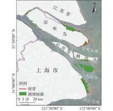
Fig.1
Map of the study area"

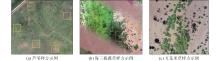
Fig.2
Representative images of sample plot"
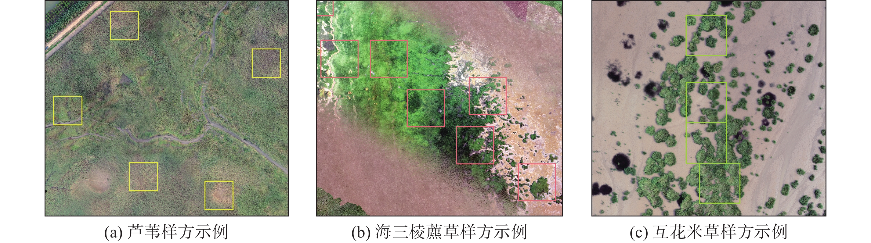
Table 1
List of commonly used vegetation indices"
| 植被指数 | 描述 | 公式 | 参考文献 |
| ARVI | 使用蓝波段来减少大气影响, 适用于大气气溶胶含量高的区域 | [ | |
| EVI | 使用蓝波段校正大气和土壤影响, 优化了植被高覆盖度区域出现的NDVI饱和现象 | [ | |
| GDVI | 在低覆盖度植被区域具有高敏感性的特点和更大的动态范围 | [ | |
| GRNDVI | 与LAI相关性高, 绿波段的加入使得其对LAI的变化反应敏感 | [ | |
| MSAVI | 较好消除了土壤背景的影响 | [ | |
| NDVI | 应用最为广泛的植被指数, 在高覆盖度植被区域易饱和, 敏感性降低 | [ | |
| VARI | 相较于NDVI, 在中高覆盖度植被区域对覆盖度变化的敏感性增加 | [ | |
| WDRVI | 相较于NDVI, 在中高LAI值下, 对LAI变化的敏感性增加 | [ |

Fig.3
Average band reflectance of sample points at different tide levels"
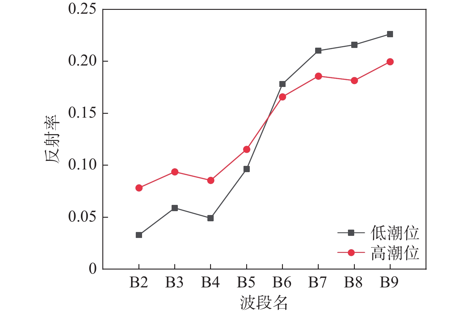
Table 2
Correlation analysis of the relationship between commonly used vegetation indices and fractional vegetation cover"
| 植被指数 | 线性模型 | 对数模型 | 指数模型 | |||||
| R2 | R2 | R2 | ||||||
| GRNDVI | ||||||||
| NDVI | ||||||||
| WDRVI | ||||||||
| GDVI | ||||||||
| MSAVI | ||||||||
| ARVI | ||||||||
| EVI | ||||||||
| VARI | ||||||||
Fig.4
Fitted curve of the relationship between vegetation indices and fractional vegetation cover"
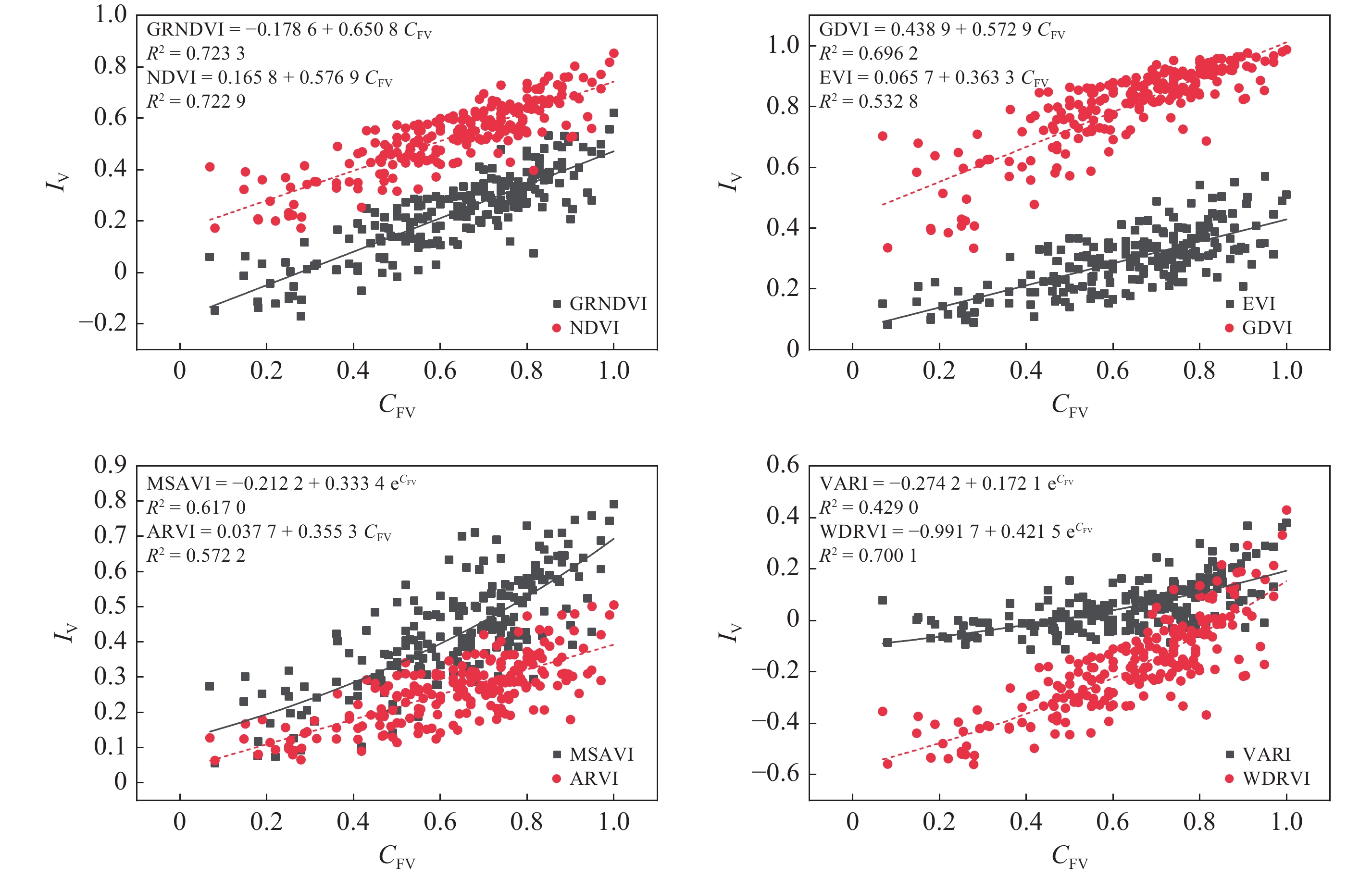
Fig.5
Sensitivity analysis of the relationship between commonly used vegetation indices and fractional vegetation cover"
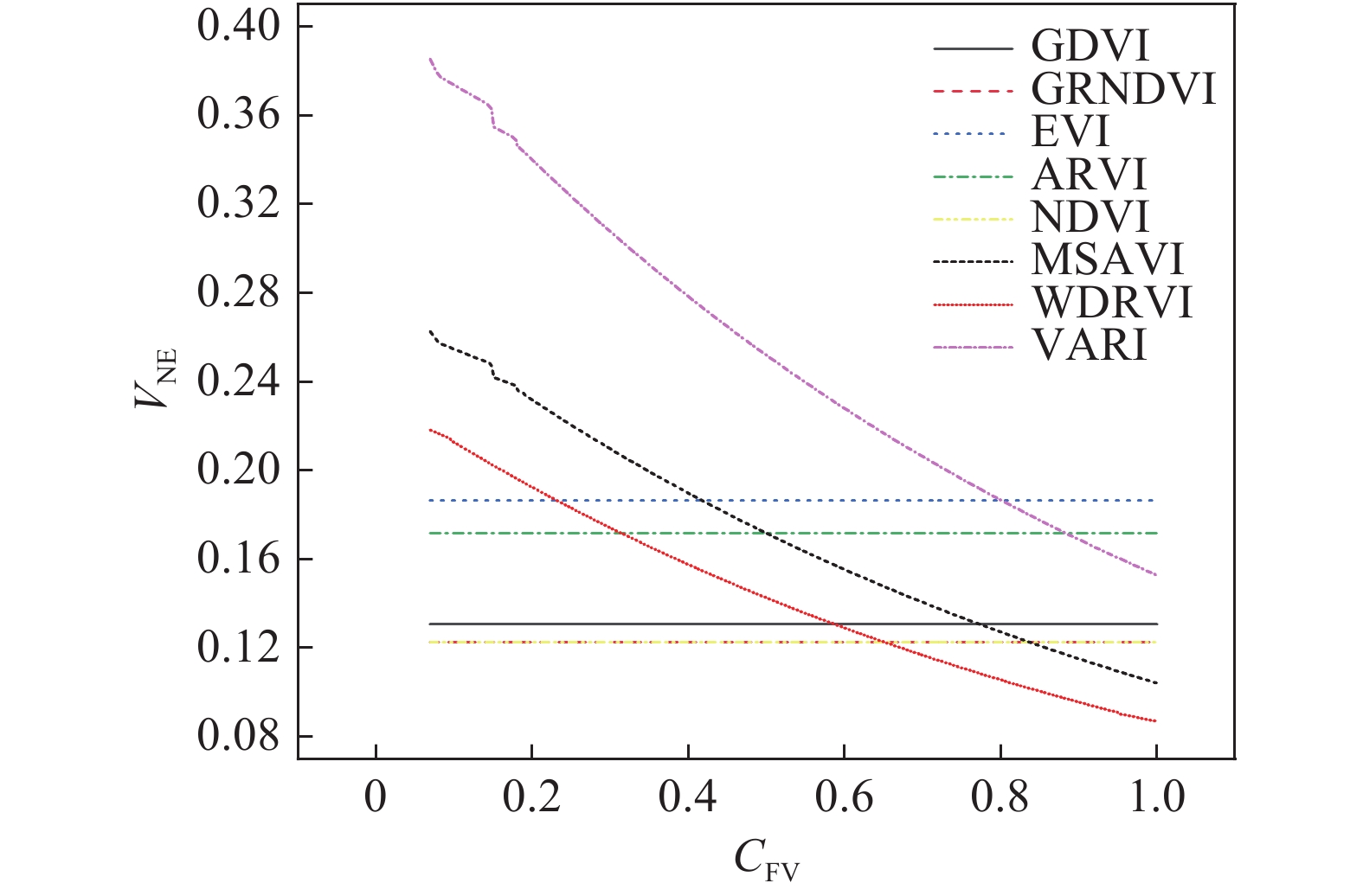
Table 3
Correlation and sensitivity analysis of the relationship between new vegetation indices and fractional vegetation cover"
| 组合方式 | R2 | 拟合方程 | |
| GRNDVI_NDWI | |||
| GRNDVI_CIWI | |||
| GRNDVI | |||
| NDVI | |||
| NDVI_CIWI | |||
| NDVI_NDWI |
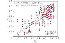
Fig.6
Fitted line of the relationship between ETFVI and fractional vegetation cover"
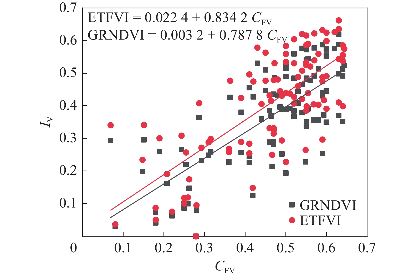
Table 4
Statistics of vegetation indices calculations"
| 植被指数 | 植被区域 | 光滩区域 | 水体区域 | |||||
| 均值 | 标准差 | 均值 | 标准差 | 均值 | 标准差 | |||
| ETFVI | ||||||||
| ARVI | ||||||||
| EVI | ||||||||
| GDVI | ||||||||
| GRNDVI | ||||||||
| MSAVI | ||||||||
| NDVI | ||||||||
| VARI | ||||||||
| WDRVI | ||||||||
Table 5
Accuracy verification for the distribution of tidal flat vegetation in the Yangtze River Estuary"
| 准确率 | 精确率 | 召回率 | F1值 | 准确率 | 精确率 | 召回率 | F1值 | |||
| ETFVI | EVI | |||||||||
| GRNDVI | WDRVI | |||||||||
| GDVI | MSAVI | |||||||||
| NDVI | VARI | |||||||||
| ARVI |
Fig.7
Distribution of tidal flat vegetation in the study area based on vegetation indices"
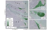
Fig.8
Map of fractional vegetation cover distribution of tidal flats in the Yangtze River Estuary in 2021"
Table 6
Verification of inversion results of fractional vegetation cover of tidal flats in the Yangtze River Estuary"
| ETFVI | MSAVI | |||||||
| GRNDVI | ARVI | |||||||
| NDVI | EVI | |||||||
| WDRVI | VARI | |||||||
| GDVI |
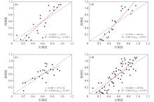
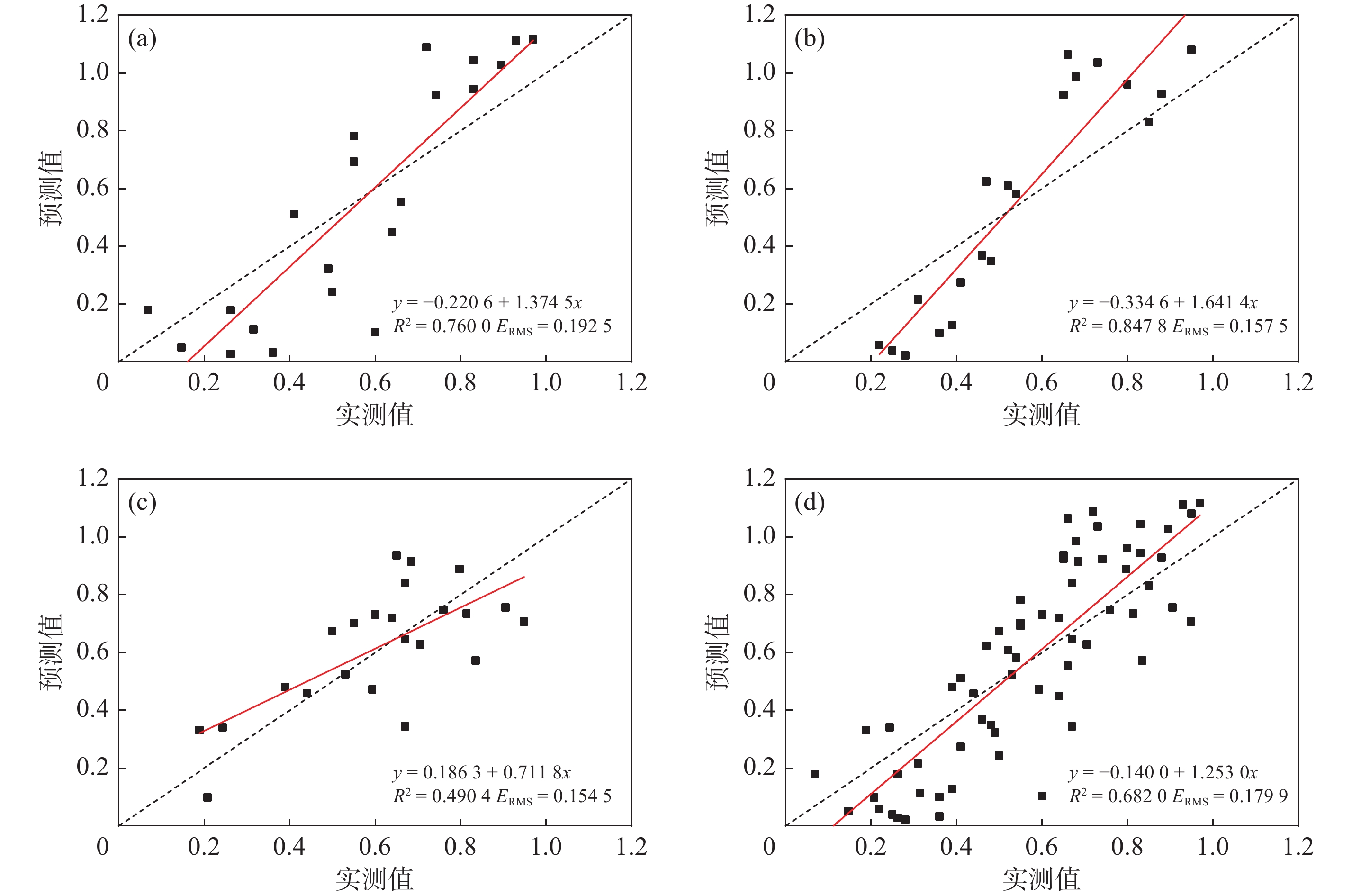
Fig.9
Verification plots of inversion results of fractional vegetation cover based on ETFVI"
| 1 | 王思, 张路路, 林伟彪, 等.. 基于MODIS-归一化植被指数的广东省植被覆盖与土地利用变化研究. 生态学报, 2022, 42 (6): 2149- 2163. |
| 2 | 赵桔超, 杨昆, 朱彦辉, 等.. 1998—2009年洞里萨湖流域湿地时空变化特征研究. 西南林业大学学报(自然科学), 2019, 39 (6): 130- 136. |
| 3 | BANNARI A, MORIN D, BONN F, et al.. A review of vegetation indices. Remote Sensing Reviews, 1995, 13 (1/2): 95- 120. |
| 4 | PEARSON R L, MILLER L D.. Remote mapping of standing crop biomass for estimation of the productivity of the shortgrass prairie. Remote Sensing of Environment, 1972, 8 (2): 1355- 1379. |
| 5 | 张杰. 长江口潮滩植被检测及时空变化的遥感研究 [D]. 上海: 华东师范大学, 2007. |
| 6 | DAY J W Jr, BOESCH D F, CLAIRAIN E J, et al.. Restoration of the Mississippi Delta: Lessons from hurricanes Katrina and Rita. Science, 2007, 315 (5819): 1679- 1684. |
| 7 | LI H, REYNOLDS J F.. A new contagion index to quantify spatial patterns of landscapes. Landscape Ecology, 1993, 8 (3): 155- 162. |
| 8 | FINLAYSON M, CRUZ R D, DAVIDSON N, et al.. Millennium ecosystem assessment: Ecosystems and human well-being: Wetlands and water synthesis. Data Fusion Concepts & Ideas, 2005, 656 (1): 87- 98. |
| 9 | TIAN B, WU W T, YANG Z Q, et al.. Drivers, trends, and potential impacts of long-term coastal reclamation in China from 1985 to 2010. Estuarine, Coastal and Shelf Science, 2016, 170, 83- 90. |
| 10 | WU W.. The generalized difference vegetation index (GDVI) for dryland characterization. Remote Sensing, 2014, 6 (2): 1211- 1233. |
| 11 | 许政勇, 孙斌, 张王菲, 等.. 基于优化三角形植被指数(TVI)的灌丛化草原植被地上生物量遥感估测方法研究. 草业学报, 2023, 32 (10): 1- 14. |
| 12 | LU J B, ZHANG Y.. Spatial distribution of an invasive plant Spartina alterniflora and its potential as biofuels in China. Ecological Engineering, 2013, 52, 175- 181. |
| 13 | KIRWAN M L, PATRICK MEGONIGAL J.. Tidal wetland stability in the face of human impacts and sea-level rise. Nature, 2013, 504 (7478): 53- 60. |
| 14 | GEDAN K B, KIRWAN M L, WOLANSKI E, et al.. The present and future role of coastal wetland vegetation in protecting shorelines: Answering recent challenges to the paradigm. Climatic Change, 2011, 106 (1): 7- 29. |
| 15 | BROMBERG GEDAN K, SILLIMAN B R, BERTNESS M D.. Centuries of human-driven change in salt marsh ecosystems. Annual Review of Marine Science, 2009, 1, 117- 141. |
| 16 | 黄桂林, 何平, 侯盟.. 中国河口湿地研究现状及展望. 应用生态学报, 2006, 17 (9): 1751- 1756. |
| 17 | 舒敏彦. 海岸带盐沼植被指数构建研究[D]. 上海: 华东师范大学, 2017. |
| 18 | 贾明明. 1973 ~ 2013年中国红树林动态变化遥感分析 [D]. 长春: 中国科学院研究生院(东北地理与农业生态研究所), 2014. |
| 19 | JIA M M, WANG Z M, MAO D H, et al.. Rapid, robust, and automated mapping of tidal flats in China using time series Sentinel-2 images and Google Earth Engine. Remote Sensing of Environment, 2021, 255, 112285. |
| 20 | 刘瑜, 韩震, 郭永飞.. 植被指数在长江口潮滩湿地植被信息提取中的应用研究. 遥感技术与应用, 2009, 24 (6): 777- 783. |
| 21 | TERRANCE BOOTH D, COX S E, BERRYMAN R D.. Point sampling digital imagery with ‘SamplePoint’. Environmental Monitoring and Assessment, 2006, 123 (1/2/3): 97- 108. |
| 22 | KAUFMAN Y J, TANRE D.. Atmospherically resistant vegetation index (ARVI) for EOS-MODIS. IEEE Transactions on Geoscience and Remote Sensing, 1992, 30 (2): 261- 270. |
| 23 | HUETE A, DIDAN K, MIURA T, et al.. Overview of the radiometric and biophysical performance of the MODIS vegetation indices. Remote Sensing of Environment, 2002, 83 (1/2): 195- 213. |
| 24 | WANG F M, HUANG J F, TANG Y L, et al.. New vegetation index and its application in estimating leaf area index of rice. Rice Science, 2007, 14 (3): 195- 203. |
| 25 | QI J, CHEHBOUNI A, HUETE A R, et al.. A modified soil adjusted vegetation index. Remote Sensing of Environment, 1994, 48 (2): 119- 126. |
| 26 | ROUSE J W Jr, HAAS R H, DEERING D, et al. Monitoring the vernal advancement and retrogradation (green wave effect) of natural vegetation [R]. Washington, DC: NASA, 1974. |
| 27 | GITELSON A A, KAUFMAN Y J, STARK R, et al.. Novel algorithms for remote estimation of vegetation fraction. Remote Sensing of Environment, 2002, 80 (1): 76- 87. |
| 28 | GITELSON A A.. Wide dynamic range vegetation index for remote quantification of biophysical characteristics of vegetation. Journal of Plant Physiology, 2004, 161 (2): 165- 173. |
| 29 | 谢宇. 回归分析[M]. 2版. 北京: 社会科学文献出版社, 2013. |
| 30 | VIÑA A, GITELSON A A, NGUY-ROBERTSON A L, et al.. Comparison of different vegetation indices for the remote assessment of green leaf area index of crops. Remote Sensing of Environment, 2011, 115 (12): 3468- 3478. |
| 31 | GITELSON A.. Remote estimation of crop fractional vegetation cover: The use of noise equivalent as an indicator of performance of vegetation indices. International Journal of Remote Sensing, 2013, 34 (17): 6054- 6066. |
| 32 | 赵欣怡. 基于时序光学和雷达影像的中国海岸带盐沼植被分类研究 [D]. 上海: 华东师范大学, 2020. |
| 33 | 舒敏彦, 田波, 丁丽霞, 等.. 长江口潮滩地带典型盐沼植被光谱特征分析. 浙江农林大学学报, 2019, 36 (1): 107- 117. |
| 34 | 安德帅, 徐丹丹, 刘月, 等.. 高光谱与拟合多光谱植被指数反演武夷山亚高山草甸LAI的对比研究. 生态科学, 2022, 41 (5): 187- 196. |
| 35 | JIANG Z Y, HUETE A R, CHEN J, et al.. Analysis of NDVI and scaled difference vegetation index retrievals of vegetation fraction. Remote Sensing of Environment, 2006, 101 (3): 366- 378. |
| 36 | MCFEETERS S K.. The use of the Normalized Difference Water Index (NDWI) in the delineation of open water features. International Journal of Remote Sensing, 1996, 17 (7): 1425- 1432. |
| 37 | 莫伟华, 孙涵, 钟仕全, 等.. MODIS水体指数模型(CIWI)研究及其应用. 遥感信息, 2007, 5 (2): 16- 21. |
| 38 | 汪小钦, 王苗苗, 王绍强, 等.. 基于可见光波段无人机遥感的植被信息提取. 农业工程学报, 2015, 31 (5): 152- 157. |
| 39 | 赵欣怡, 田波, 牛莹, 等.. Sentinel-1时序后向散射特征的海岸带盐沼植被分类——以长江口为例. 遥感学报, 2022, 26 (4): 672- 682. |
| 40 | 史宇骁, 李阳, 孟翊, 等.. 1989—2020年长江口九段沙湿地格局演变及影响因素. 应用生态学报, 2022, 33 (8): 2229- 2236. |
| 41 | 张婷玉, 袁琳, 张超, 等.. 海岸工程及生物入侵对上海南汇东滩海岸带格局演变的影响. 华东师范大学学报(自然科学版), 2023, (3): 167- 180. |
| 42 | 杨斌. 高氮背景下长江口南汇边滩互花米草盐沼N2O和CH4通量及影响因素 [D]. 上海: 华东师范大学, 2021. |
| [1] | Hao CHEN, Xianqiang HE, Run LI, Fang CAO. Machine learning-based remote sensing retrievals of dissolved organic carbon in the Yangtze River Estuary [J]. Journal of East China Normal University(Natural Science), 2024, 2024(4): 123-136. |
| [2] | Zhi JIN, Jianrong ZHU, Wei QIU. Effects of cascade reservoirs in the Yangtze River Basin on estuarine saltwater intrusion and freshwater resources during late summer and early autumn [J]. Journal of East China Normal University(Natural Science), 2024, 2024(1): 90-103. |
| [3] | Jiaming CHEN, Shiming WANG, Rongrong YANG, Ziyan CHEN, Xia LIANG, Lijun HOU. Temperature adaptability of dark carbon fixation in seawater fromthe Yangtze River Estuary [J]. Journal of East China Normal University(Natural Science), 2024, 2024(1): 104-112. |
| [4] | Zhipeng LI, Jianrong ZHU. Numerical simulation of the North Branch regime change impact on saltwater intrusion in the Yangtze River Estuary from 2007 to 2016 [J]. Journal of East China Normal University(Natural Science), 2022, 2022(3): 109-124. |
| [5] | Zhiyong YOU, Bolin LIU, Cheng LIU, Dengzhou GAO. Temperature sensitivity and controlling factors of nitrogen fixation processes in sediments of the Yangtze River Estuary [J]. Journal of East China Normal University(Natural Science), 2022, 2022(3): 101-108. |
| [6] | QIAN Yurong;;LI Jianlong;GAN Xiaoyu;YANG Feng. Research of road factors in urban expansion basedon BP network: A case study of Zhangjiagang city [J]. Journal of East China Normal University(Natural Sc, 2009, 2009(3): 63-71. |
| [7] | ZHANG Jie;SHEN Fang;LIU Zhi-guo. Spectral Analysis and Remote Sensing Detection of Tidal Shoal′sVegetation in the Estuary of Yangtse River(Chinese) [J]. Journal of East China Normal University(Natural Sc, 2007, 2007(4): 42-48. |
| [8] | ZHANG Heng;LU Jian-jian. Calculation of the Taxonomic Diversity of Fish Communities in the Yangtze River Estuary(Chinese) [J]. Journal of East China Normal University(Natural Sc, 2007, 2007(2): 11-22. |
| Viewed | ||||||
|
Full text |
|
|||||
|
Abstract |
|
|||||