 中国综合性科技类核心期刊(北大核心)
Journal of East China Normal University(Natural Science) ›› 2024, Vol. 2024 ›› Issue (4): 123-136.doi: 10.3969/j.issn.1000-5641.2024.04.012
• Remote Sensing and Geographic Information System • Previous Articles
Hao CHEN1, Xianqiang HE2, Run LI1, Fang CAO1,*( )
)
Received:2023-03-22
Accepted:2023-04-18
Online:2024-07-25
Published:2024-07-23
Contact:
Fang CAO
E-mail:fcao@sklec.ecnu.edu.cn
CLC Number:
Hao CHEN, Xianqiang HE, Run LI, Fang CAO. Machine learning-based remote sensing retrievals of dissolved organic carbon in the Yangtze River Estuary[J]. Journal of East China Normal University(Natural Science), 2024, 2024(4): 123-136.
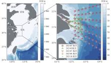
Fig.1
Study area illustrating in situ sampling stations occupied"
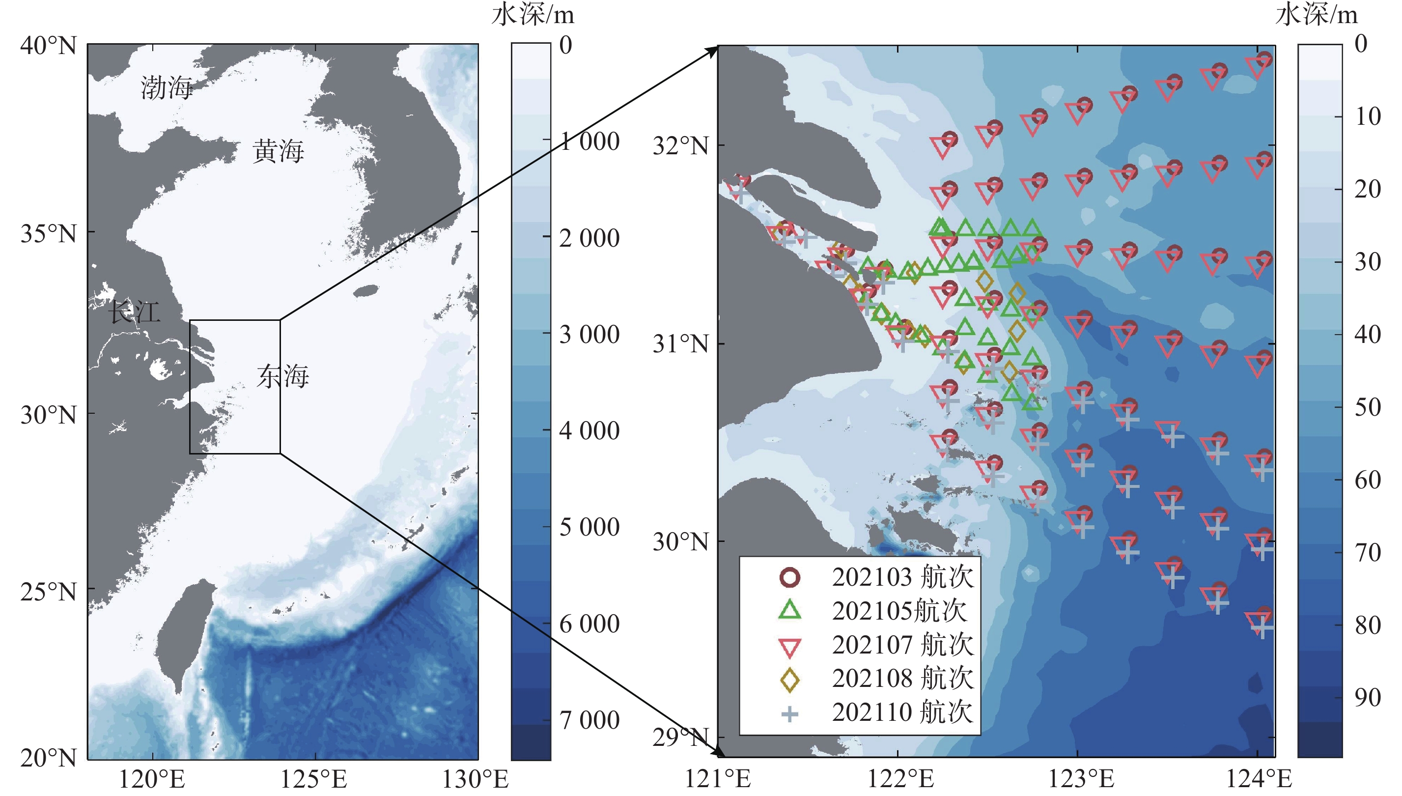
Table 1
Sampling details for the Yangtze River Estuary and its adjacent East China Sea margins"
| 季节 | 观测日期 | 样品数量 | ||
| Rrs(λ) | CDOM | DOC | ||
| 冬季 | 2021年3月8—14日 | 10 | 63 | 63 |
| 春季 | 2021年5月12—24日 | 22 | 67 | 67 |
| 夏季 | 2021年7月11—19日 | 16 | 63 | 63 |
| 夏季 | 2021年8月27—29日 | 6 | 8 | 8 |
| 秋季 | 2021年10月12—20日 | 17 | 31 | 31 |
| 合计 | 71 | 232 | 232 | |
Fig.2
Flow chart of the CDOM and DOC algorithms development"
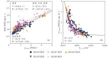
Fig.3
Relationship between measured CDOM absorption characteristics and DOC concentration"
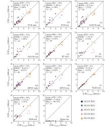
Fig.4
Results of training set and validation set based on aCDOM(300) algorithms"
Table 2
Results of the machine learning model fitting of the aCDOM(300) models"
| 模型 | 训练集(N = 49) | 验证集(N = 22) | |||||
| RMSE/m?1 | MAPD/% | Bias/% | RMSE/m?1 | MAPD/% | Bias/% | ||
| SVR | 0.67 | 27 | 2.68 | 1.00 | 38 | 5.78 | |
| NuSVR | 0.75 | 26 | ?2.97 | 1.05 | 32 | ?1.89 | |
| RF | 0.45 | 16 | 0.76 | 1.42 | 45 | ?5.14 | |
| BPNN | 0.54 | 19 | ?0.01 | 0.92 | 34 | 4.55 | |
| XGB | 0.24 | 6 | ?4.15 | 1.23 | 39 | ?7.35 | |
| Moon | ?? | ?? | ?? | 3.56 | 95 | ?96.15 | |
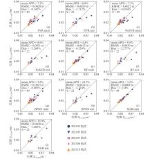
Fig.5
Results of training set and validation set based on S275–295 algorithms"
Table 3
Results of the machine learning methods fitting of the S275–295 models"
| 模型 | 训练集 (N = 49) | 验证集 (N = 22) | |||||
| RMSE /nm-1 | MAPD /% | Bias /% | RMSE /nm-1 | MAPD /% | Bias /% | ||
| SVR | 0.0020 | 7.2 | ?0.342 | 0.0029 | 8.8 | ?2.712 | |
| NuSVR | 0.0022 | 7.3 | ?0.934 | 0.0031 | 8.6 | ?3.260 | |
| RF | 0.0012 | 4.4 | ?0.350 | 0.0030 | 9.5 | ?2.277 | |
| BPNN | 0.0015 | 5.8 | ?0.003 | 0.0034 | 10.5 | ?2.224 | |
| XGB | 0.0008 | 3.2 | 1.314 | 0.0030 | 10.0 | ?1.266 | |
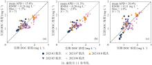
Fig.6
Fitting results of DOC from (a) aCDOM(300)–DOC model, (b) aCDOM(300)–DOC seasonal model and (c) S275–295–aCDOM*(300) model"
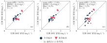
Fig.7
Satellite validation results of DOC from (a) aCDOM(300)–DOC model, (b) aCDOM(300)–DOC seasonal model and (c) S275–295–aCDOM*(300) model"

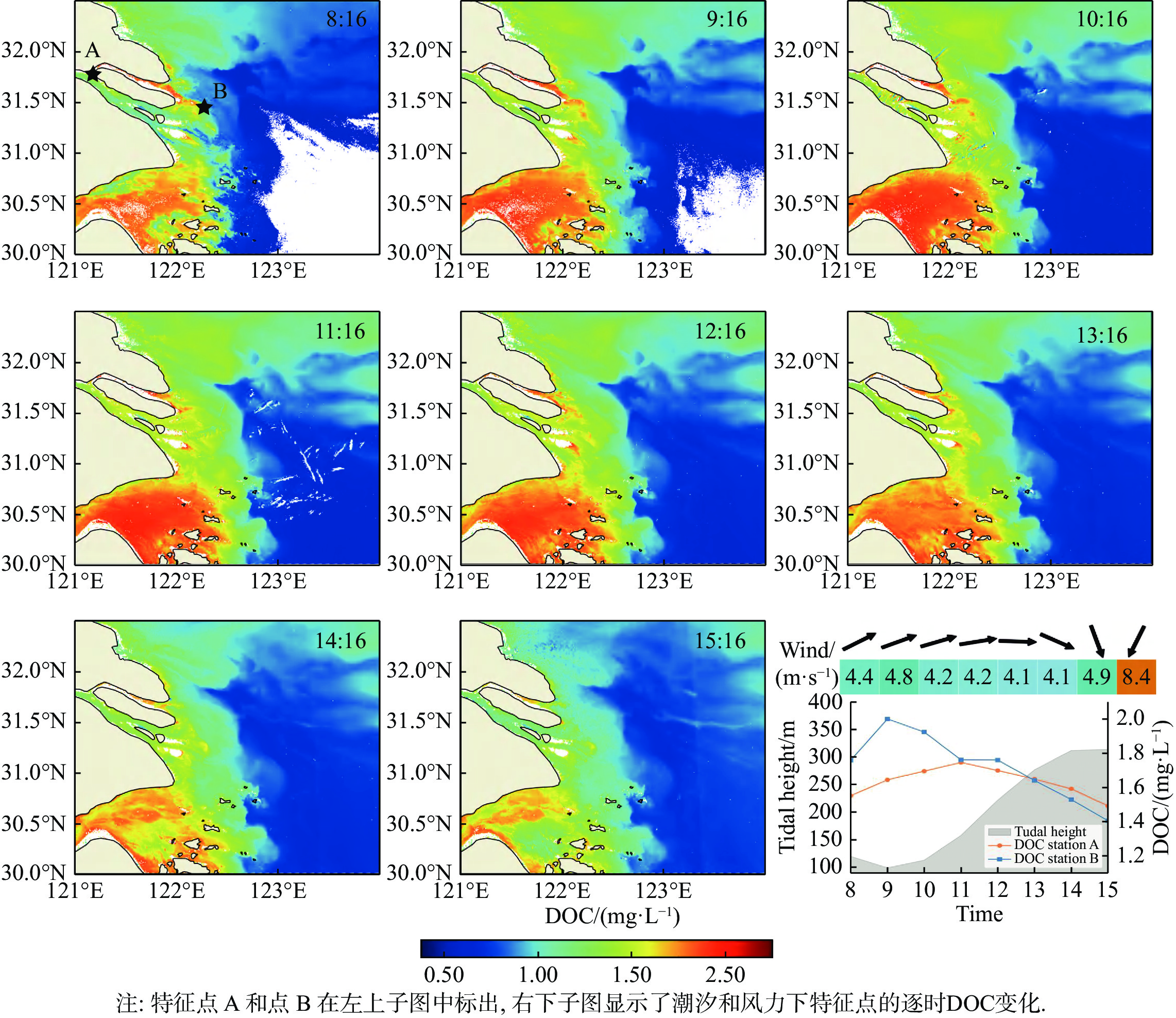
Fig.8
Hourly change of DOC concentration in the Yangtze River Estuary on March 15, 2020, and the change of characteristic points with tide and wind"
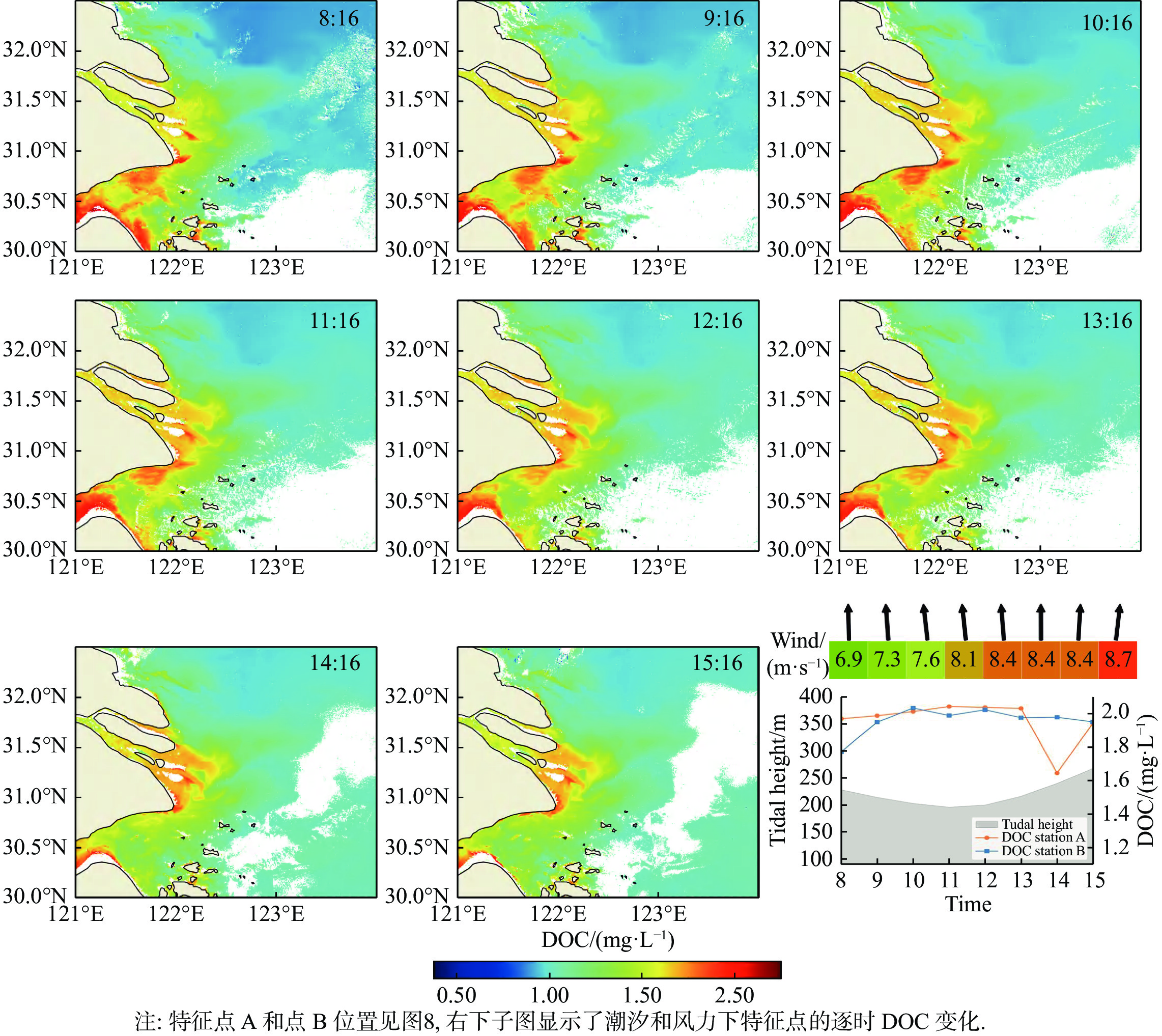
Fig.9
Hourly changes in DOC concentrations in the Yangtze River Estuary on August 13, 2020, and the change of characteristic points with tide and wind"
| 1 | HANSELL D A, CARLSON C A.. Deep ocean gradients in dissolved organic carbon concentrations. Nature, 1998, 395 (6699): 263- 266. |
| 2 | 戴民汉, 翟惟东, 鲁中明, 等.. 中国区域碳循环研究进展与展望. 地球科学进展, 2004, 19 (1): 120- 130. |
| 3 | 潘德炉, 刘琼, 白雁.. DOC遥感研究进展——基于全球大河DOC与CDOM保守性特征. 海洋学报(中文版), 2012, 34 (4): 1- 11. |
| 4 | FICHOT C G, BENNER R.. The spectral slope coefficient of chromophoric dissolved organic matter (S275–295) as a tracer of terrigenous dissolved organic carbon in river-influenced ocean margins. Limnology and Oceanography, 2012, 57 (5): 1453- 1466. |
| 5 | MASSICOTTE P, ASMALA E, STEDMON C, et al.. Global distribution of dissolved organic matter along the aquatic continuum: Across rivers, lakes and oceans. Science of the Total Environment, 2017, 609, 180- 191. |
| 6 | GRIFFIN C G, MCCLELLAND J W, FREY K E, et al.. Quantifying CDOM and DOC in major Arctic rivers during ice-free conditions using Landsat TM and ETM + data. Remote Sensing of Environment, 2018, 209, 395- 409. |
| 7 | CHEN J, ZHU W, TIAN Y Q, et al.. Monitoring dissolved organic carbon by combining Landsat-8 and Sentinel-2 satellites: Case study in Saginaw River estuary, Lake Huron. The Science of the Total Environment, 2020, 718, 137374. |
| 8 | MANNINO A, RUSS M E, HOOKER S B.. Algorithm development and validation for satellite-derived distributions of DOC and CDOM in the U. S. Middle Atlantic Bight. Journal of Geophysical Research, 2008, 113 (C7): C07051. |
| 9 | HELMS J R, STUBBINS A, RITCHIE J D, et al.. Absorption spectral slopes and slope ratios as indicators of molecular weight, source, and photobleaching of chromophoric dissolved organic matter. Limnology and Oceanography, 2008, 53 (3): 955- 969. |
| 10 | FICHOT C G, BENNER R.. A novel method to estimate DOC concentrations from CDOM absorption coefficients in coastal waters. Geophysical Research Letters, 2011, 38 (3): L03610. |
| 11 | VANTREPOTTE V, DANHIEZ F, LOISEL H, et al.. CDOM-DOC relationship in contrasted coastal waters: Implication for DOC retrieval from ocean color remote sensing observation. Optics Express, 2015, 23 (1): 33- 54. |
| 12 | YU X, SHEN F, LIU Y.. Light absorption properties of CDOM in the Changjiang (Yangtze) estuarine and coastal waters: An alternative approach for DOC estimation. Estuarine, Coastal and Shelf Science, 2016, 181, 302- 311. |
| 13 | CAO F, TZORTZIOU M, HU C, et al.. Remote sensing retrievals of colored dissolved organic matter and dissolved organic carbon dynamics in North American estuaries and their margins. Remote Sensing of Environment, 2018, 205, 151- 165. |
| 14 | BAI Y, HE X, PAN D, et al.. Summertime Changjiang River plume variation during 1998–2010. Journal of Geophysical Research: Oceans, 2014, 119 (9): 6238- 6257. |
| 15 | WU H, SHEN J, ZHU J, et al.. Characteristics of the Changjiang plume and its extension along the Jiangsu Coast. Continental Shelf Research, 2014, 76, 108- 123. |
| 16 | YANG B, CAO L, LIU S, et al.. Biogeochemistry of bulk organic matter and biogenic elements in surface sediments of the Yangtze River Estuary and adjacent sea. Marine Pollution Bulletin, 2015, 96 (1): 471- 484. |
| 17 | GUO L, SANTSCHI P H, WARNKEN K W.. Dynamics of dissolved organic carbon (DOC) in oceanic environments. Limnology and oceanography, 1995, 40 (8): 1392- 1403. |
| 18 | RUDDICK K G, DE CAUWER V, PARK Y, et al.. Seaborne measurements of near infrared water-leaving reflectance: The similarity spectrum for turbid waters. Limnology and Oceanography, 2006, 51 (2): 1167- 1179. |
| 19 | RYU J, HAN H, CHO S, et al.. Overview of geostationary ocean color imager (GOCI) and GOCI data processing system (GDPS). Ocean Science Journal, 2012, 47 (3): 223- 233. |
| 20 | HE X, BAI Y, PAN D, et al.. Atmospheric correction of satellite ocean color imagery using the ultraviolet wavelength for highly turbid waters. Optics Express, 2012, 20 (18): 20754- 20770. |
| 21 | HE X, BAI Y, PAN D, et al.. Using geostationary satellite ocean color data to map the diurnal dynamics of suspended particulate matter in coastal waters. Remote Sensing of Environment, 2013, 133, 225- 239. |
| 22 | LIU D, BAI Y, HE X, et al.. Satellite estimation of particulate organic carbon flux from Changjiang River to the estuary. Remote Sensing of Environment, 2019, 223, 307- 319. |
| 23 | ZHAO J, CAO W, XU Z, et al.. Estimating CDOM concentration in highly turbid estuarine coastal waters. Journal of Geophysical Research: Oceans, 2018, 123 (8): 5856- 5873. |
| 24 | 吴志明, 李建超, 王睿, 等.. 基于随机森林的内陆湖泊水体有色可溶性有机物(CDOM)浓度遥感估算. 湖泊科学, 2018, 30 (4): 979- 991. |
| 25 | 孙璐, 蒋锦刚, 朱渭宁.. 基于GOCI影像的长江口及其邻近海域CDOM遥感反演及其日内变化研究. 海洋学报, 2017, 39 (9): 133- 145. |
| 26 | LIU H, LI Q, BAI Y, et al.. Improving satellite retrieval of oceanic particulate organic carbon concentrations using machine learning methods. Remote Sensing of Environment, 2021, 256, 112316. |
| 27 | SHEN M, LUO J, CAO Z, et al.. Random forest: An optimal chlorophyll-a algorithm for optically complex inland water suffering atmospheric correction uncertainties. Journal of Hydrology, 2022, 615, 128685. |
| 28 | SUN X, ZHANG Y, ZHANG Y, et al.. Machine learning algorithms for chromophoric dissolved organic matter (CDOM) estimation based on Landsat 8 images. Remote Sensing, 2021, 13 (18): 3560. |
| 29 | MOREL A, GENTILI B.. A simple band ratio technique to quantify the colored dissolved and detrital organic material from ocean color remotely sensed data. Remote Sensing of Environment, 2009, 113 (5): 998- 1011. |
| 30 | SISWANTO E, TANG J, YAMAGUCHI H, et al.. Empirical ocean-color algorithms to retrieve chlorophyll-a, total suspended matter, and colored dissolved organic matter absorption coefficient in the Yellow and East China Seas. Journal of Oceanography, 2011, 67 (5): 627- 650. |
| 31 | MANNINO A, NOVAK M G, HOOKER S B, et al.. Algorithm development and validation of CDOM properties for estuarine and continental shelf waters along the northeastern US coast. Remote Sensing of Environment, 2014, 152, 576- 602. |
| 32 | MÉLIN F, ZIBORDI G, BERTHON J, et al.. Assessment of MERIS reflectance data as processed with SeaDAS over the European seas. Optics Express, 2011, 19 (25): 25657- 25671. |
| 33 | MOON J, AHN Y, RYU J, et al.. Development of ocean environmental algorithms for Geostationary Ocean Color Imager (GOCI). Korean Journal of Remote Sensing, 2010, 26 (2): 189- 207. |
| 34 | 高源, 明玥, 高磊.. 2019年长江口及其邻近海域溶解有机物的分布和季节变化特征. 海洋环境科学, 2022, 41 (1): 40- 47. |
| 35 | 张淑坤, 明玥, 高磊.. 2020年夏季长江流域特大洪水期间长江口POC和DOC的分布特征. 海洋环境科学, 2022, 41 (5): 653- 659. |
| 36 | 李倩, 张珊珊, 线薇微.. 长江口有机碳的时空分异及耦合行为. 海洋环境科学, 2022, 41 (1): 24- 31. |
| 37 | 叶君, 姚鹏, 徐亚宏, 等.. 长江口盐度梯度下不同形态碳的分布、来源与混合行为. 海洋学报, 2019, 41 (4): 15- 26. |
| 38 | SONG S, GAO L, GE J, et al.. Tidal effects on variations in organic and inorganic biogeochemical components in Changjiang (Yangtze River) Estuary and the adjacent East China Sea. Journal of Marine Systems, 2022, 227, 103692. |
| [1] | Yong ZHANG, Hui WANG, Chuanhua ZHU, Hao ZHOU, Yu ZHAN, Can LI, Yifan XIAO, Lili YANG, Jiaqi LIU. Evaluation of eutrophication by satellite remote sensing based on machine learning: A case study of Huancheng River in Hefei [J]. Journal of East China Normal University(Natural Science), 2024, 2024(1): 1-8, 112. |
| [2] | Jiaming CHEN, Shiming WANG, Rongrong YANG, Ziyan CHEN, Xia LIANG, Lijun HOU. Temperature adaptability of dark carbon fixation in seawater fromthe Yangtze River Estuary [J]. Journal of East China Normal University(Natural Science), 2024, 2024(1): 104-112. |
| [3] | Zhi JIN, Jianrong ZHU, Wei QIU. Effects of cascade reservoirs in the Yangtze River Basin on estuarine saltwater intrusion and freshwater resources during late summer and early autumn [J]. Journal of East China Normal University(Natural Science), 2024, 2024(1): 90-103. |
| [4] | Xiangyun GAO, Dan MENG, Mingkai LUO, Jun WANG, Liping ZHANG, Chao KONG. Privacy-preserving cloud-end collaborative training [J]. Journal of East China Normal University(Natural Science), 2023, 2023(5): 77-89. |
| [5] | Zhiyong YOU, Bolin LIU, Cheng LIU, Dengzhou GAO. Temperature sensitivity and controlling factors of nitrogen fixation processes in sediments of the Yangtze River Estuary [J]. Journal of East China Normal University(Natural Science), 2022, 2022(3): 101-108. |
| [6] | Zhipeng LI, Jianrong ZHU. Numerical simulation of the North Branch regime change impact on saltwater intrusion in the Yangtze River Estuary from 2007 to 2016 [J]. Journal of East China Normal University(Natural Science), 2022, 2022(3): 109-124. |
| [7] | Tonghui ZHOU, Yinping LIU. Determination of convergence control parameters in homotopy analysis solutions based on machine learning technique [J]. Journal of East China Normal University(Natural Science), 2022, 2022(2): 34-44. |
| [8] | Mengchen YANG, Xudong CHEN, Peng CAI, Lyu NI. Survey of early time series classification methods [J]. Journal of East China Normal University(Natural Science), 2021, 2021(5): 115-133. |
| [9] | Yang YU, Huiqi HU, Xuan ZHOU. Optimization of LSM-tree storage systems based on non-volatile memory [J]. Journal of East China Normal University(Natural Science), 2021, 2021(5): 37-47. |
| [10] | ZHU Kun, WU Ying, Qi Lijun. Spatiotemporal variations and influencing factors of organic carbon content in the urban rivers of Shanghai [J]. Journal of East China Normal University(Natural Science), 2020, 2020(1): 150-158. |
| [11] | XIAO YAO, BI Jun-fang, HAN YI, DONG Qi-wen. Study of click through rate prediction in online advertisement [J]. Journal of East China Normal University(Natural Sc, 2017, 2017(5): 80-86,100. |
| [12] | ZHANG Heng;LU Jian-jian. Calculation of the Taxonomic Diversity of Fish Communities in the Yangtze River Estuary(Chinese) [J]. Journal of East China Normal University(Natural Sc, 2007, 2007(2): 11-22. |
| Viewed | ||||||
|
Full text |
|
|||||
|
Abstract |
|
|||||