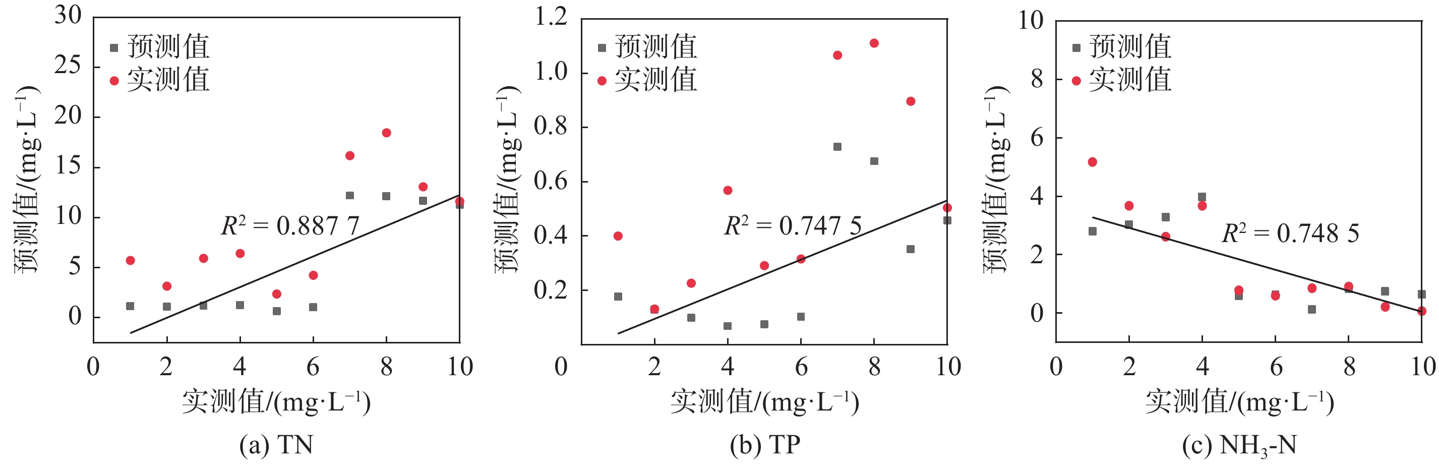
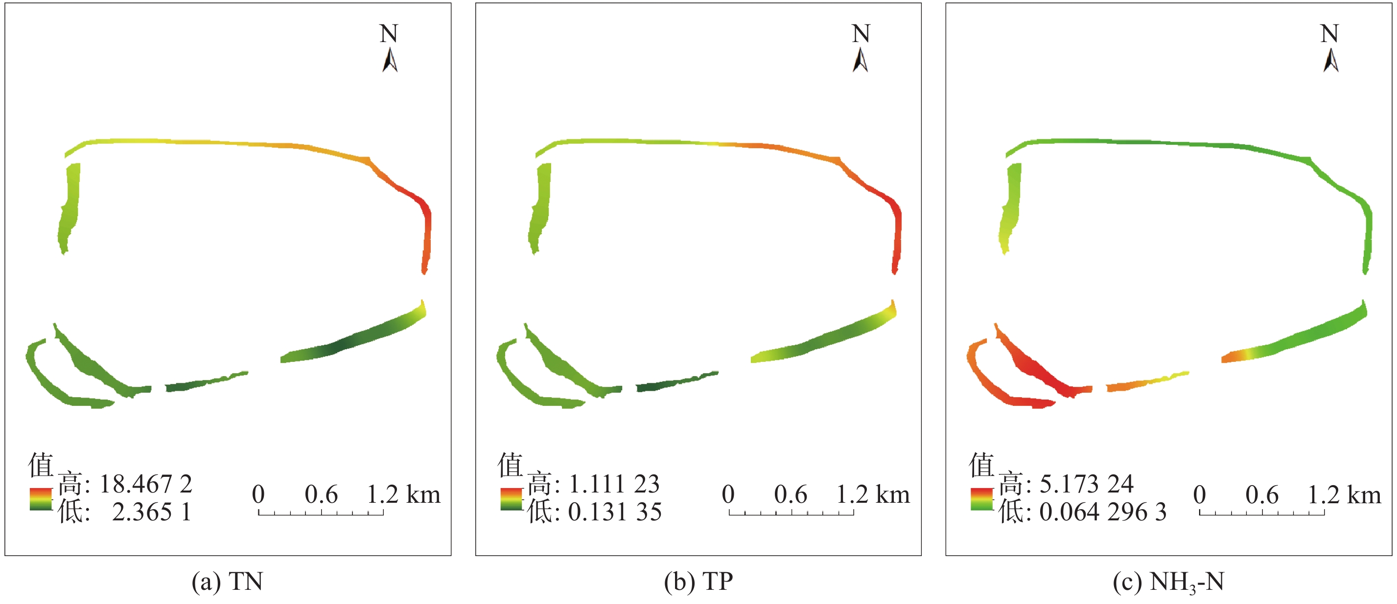
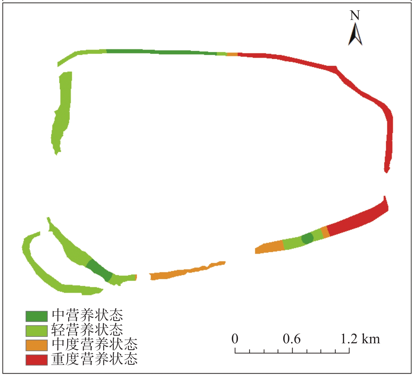
| 1 |
ADUSEI Y Y, QUAYE-BALLARD J, ADJAOTTOR A A, et al.. Spatial prediction and mapping of water quality of Owabi reservoir from satellite imageries and machine learning models. The Egyptian Journal of Remote Sensing and Space Sciences, 2021, 24 (3): 825- 833.
|
| 2 |
SHARAF E D E, ZHANG Y, ALAELDIN S.. Mapping concentrations of surface water quality parameters using a novel remote sensing and artificial intelligence framework. International Journal of Remote Sensing, 2017, 38 (4): 1023- 1042.
|
| 3 |
KRISHNARAJ A, HONNASIDDAIAH R.. Remote sensing and machine learning based framework for the assessment of spatio-temporal water quality in the Middle Ganga Basin. Environmental Science and Pollution Research, 2022, 27 (29): 64939- 64958.
|
| 4 |
SAGAN V, PETERSON K T, MAIMAITIJIANG M, et al.. Monitoring inland water quality using remote sensing: Potential and limitations of spectral indices, bio-optical simulations, machine learning, and cloud computing. Earth-Science Reviews, 2020, 205, 103187.
|
| 5 |
CHEN J, FU R, CHEN S, et al. Remote sensing big data for water environment monitoring: Current status, challenges, and future prospects [J]. Earth’s Future, 2022, 10(2): e2021EF002289.
|
| 6 |
JIANG Q O, XU L D, WANG M L, et al.. Retrieval model for total nitrogen concentration based on UAV hyper spectral remote sensing data and machine learning algorithms – A case study in the Miyun Reservoir, China. Ecological Indicators, 2021, 124, 107356.
|
| 7 |
WU C F, WU J P, Qi J G, et al.. Empirical estimation of total phosphorus concentration in the mainstream of the Qiantang River in China using Landsat TM data. International Journal of Remote Sensing, 2010, 21 (9): 2309- 2324.
|
| 8 |
ZHAO Y B, YU T, HU B L, et al.. Retrieval of water quality parameters based on near-surface remote sensing and machine learning algorithm. Remote Sensing, 2022, 14 (21): 5305.
|
| 9 |
王延军, 徐敏, 孟凡生, 等.. 长江中游黄盖湖富营养化趋势分析及原因诊断. 湖泊科学, 2023, 35 (4): 1- 14.
|
| 10 |
HE Y, GONG Z, ZHENG Y, et al.. Inland reservoir water quality inversion and eutrophication evaluation using BP neural network and remote sensing imagery: A case study of Dashahe Reservoir. Water, 2021, 13 (20): 2844.
|
| 11 |
生态环境部. 水质 总氮的测定 碱性过硫酸钾消解紫外分光光度法: HJ 636-2012 [S]. 北京: 中国环境科学出版社, 2012.
|
| 12 |
生态环境部. 水质 氨氮的测定 纳氏试剂分光光度法: HJ 535-2009 [S]. 北京: 中国环境科学出版社, 2009.
|
| 13 |
生态环境部. 水质 总磷的测定 钼酸铵分光光度法: GB11893-89 [S]. 北京: 中国标准出版社, 1989.
|
| 14 |
GUO R, DENG R R, LI J Y, et al.. Remote sensing retrieval of total nitrogen in the Pearl River Delta based on Landsat8. Water, 2022, 14 (22): 3710.
|
| 15 |
PANDIS N.. Correlation and linear regression. American Journal of Orthodontics and Dentofacial Orthopedics, 2016, 149 (2): 299.
|
| 16 |
TIAN S, GUO H, XU W, et al.. Remote sensing retrieval of inland water quality parameters using Sentinel-2 and multiple machine learning algorithms. Environmental Science and Pollution Research, 2022, 30, 18617- 18630.
|
| 17 |
XIAO X, ZHANG T, ZHONG X, et al.. Support vector regression snow-depth retrieval algorithm using passive microwave remote sensing data. Remote Sensing of Environment, 2018, 210, 48- 64.
|
| 18 |
NAJAFZADEH M, NIAZMARDI S.. A novel multiple-kernel support vector regression aigorithm for estimation of water quality parameters. Natural Resources Research, 2021, 30, 3761- 3775.
|
| 19 |
SHEN H, MA Y, LIN C, et al.. Hierarchical Bayesian support vector regression with model parameter calibration for reliability modeling and prediction. Reliability Engineering and System Safety, 2021, 206, 107268.
|
| 20 |
LEE J H, SHI Z, GAO Z.. On LASSO for predictive regression. Journal of Econometrics, 2021, 229 (2): 322- 349.
|
| 21 |
魏广芬, 李梦递, 赵捷.. 基于 DFI-RSE 电子鼻传感器阵列优化的葡萄酒 SO2 检测. 农业工程学报, 2022, 38 (7): 291- 299.
|
| 22 |
GHOSH S M, BEHERA M D.. Aboveground biomass estimation using multi-sensor data synergy and machine learning algorithms in a dense tropical forest. Applied Geography, 2018, 96, 29- 40.
|
| 23 |
殷飞. 水体营养状况评价方法研究 [J]. 科技创新与应用, 2017, 30: 99-100.
|
| 24 |
陈昭明, 王伟, 赵迎.. 三峡水库支流水体富营养化现状及防治策略. 环境工程, 2019, 37 (4): 32- 37.
|
 ), Hui WANG1,3, Chuanhua ZHU1, Hao ZHOU1, Yu ZHAN1, Can LI1, Yifan XIAO1, Lili YANG1, Jiaqi LIU1
 中国综合性科技类核心期刊(北大核心)