 中文核心期刊
Journal of East China Normal University(Natural Science) ›› 2021, Vol. 2021 ›› Issue (6): 174-186.doi: 10.3969/j.issn.1000-5641.2021.06.017
• Estuary and Coastal Research • Previous Articles
Jinghua GU1( ), Jianrong ZHU1,*(), Cheng QIU2, Rui YUAN3, Zhipeng LI1, Wei QIU1, Zhi JIN1
Received:2021-01-27
Online:2021-11-25
Published:2021-11-26
Contact:
Jianrong ZHU
E-mail:jhgu@sklec.ecnu.edu.cn;jrzhu@sklec.ecnu.edu.cn
CLC Number:
Jinghua GU, Jianrong ZHU, Cheng QIU, Rui YUAN, Zhipeng LI, Wei QIU, Zhi JIN. Analysis of the long-term evolution of saltwater intrusion in the Changjiang Estuary[J]. Journal of East China Normal University(Natural Science), 2021, 2021(6): 174-186.
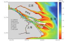
Fig.1
A map of the situation of the Changjiang Estuary"

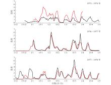
Fig.2
Temporal variations in the measured salinity from December to April of 1973—1978"
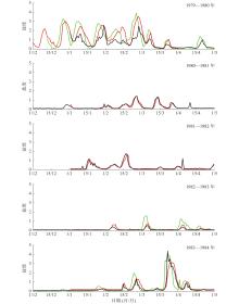
Fig.3
Temporal variations in the measured salinity from December to April of 1979—1984"
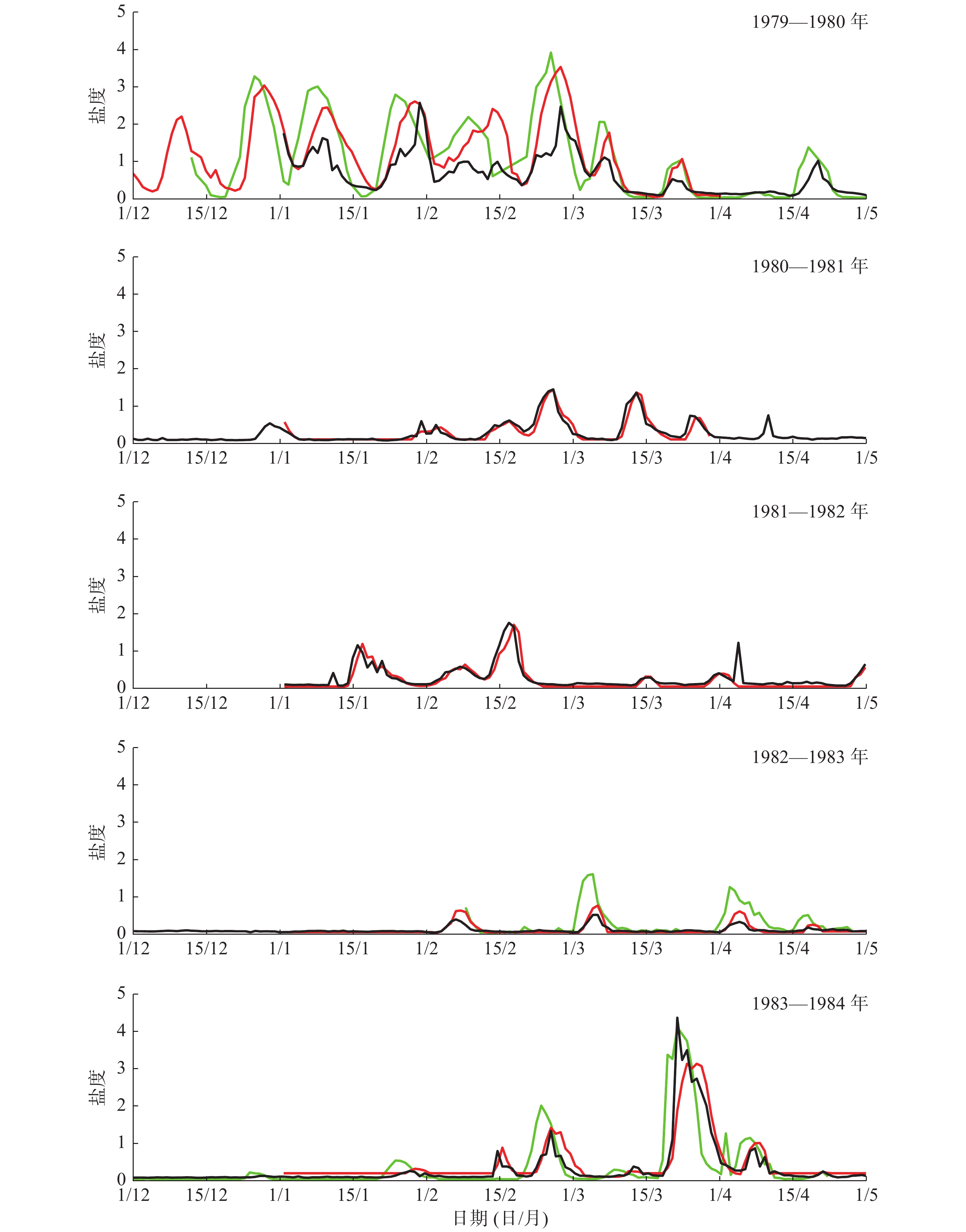
Fig.4
Temporal variations in the measured salinity from December to April of 1983—1988"
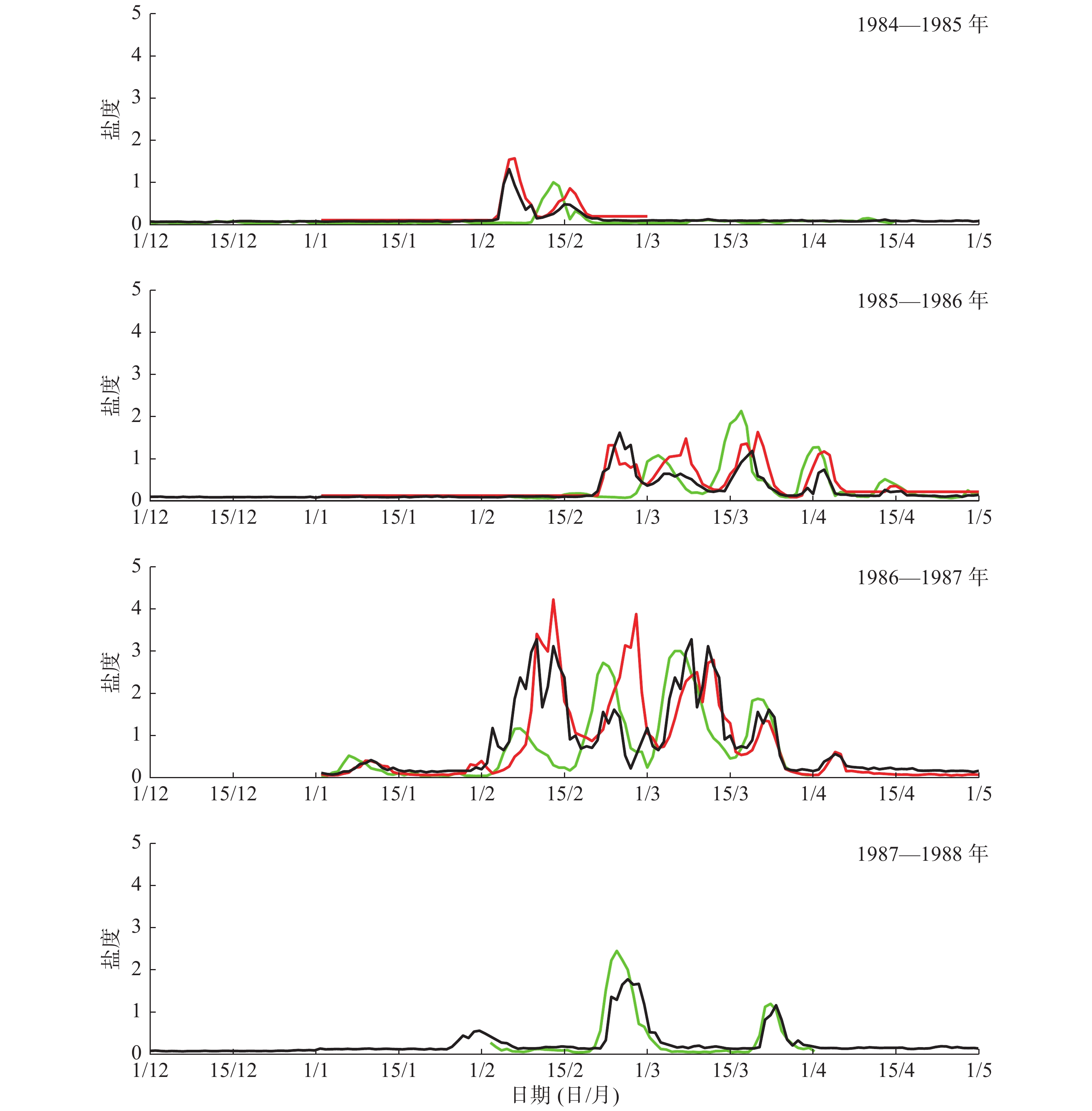
Fig.5
Temporal variations in the measured salinity from December to April of 1991—1996"

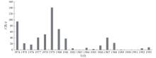
Fig.6
Days of saltwater intrusion at the water intake of the Wusong water plant from 1974 to 1993"
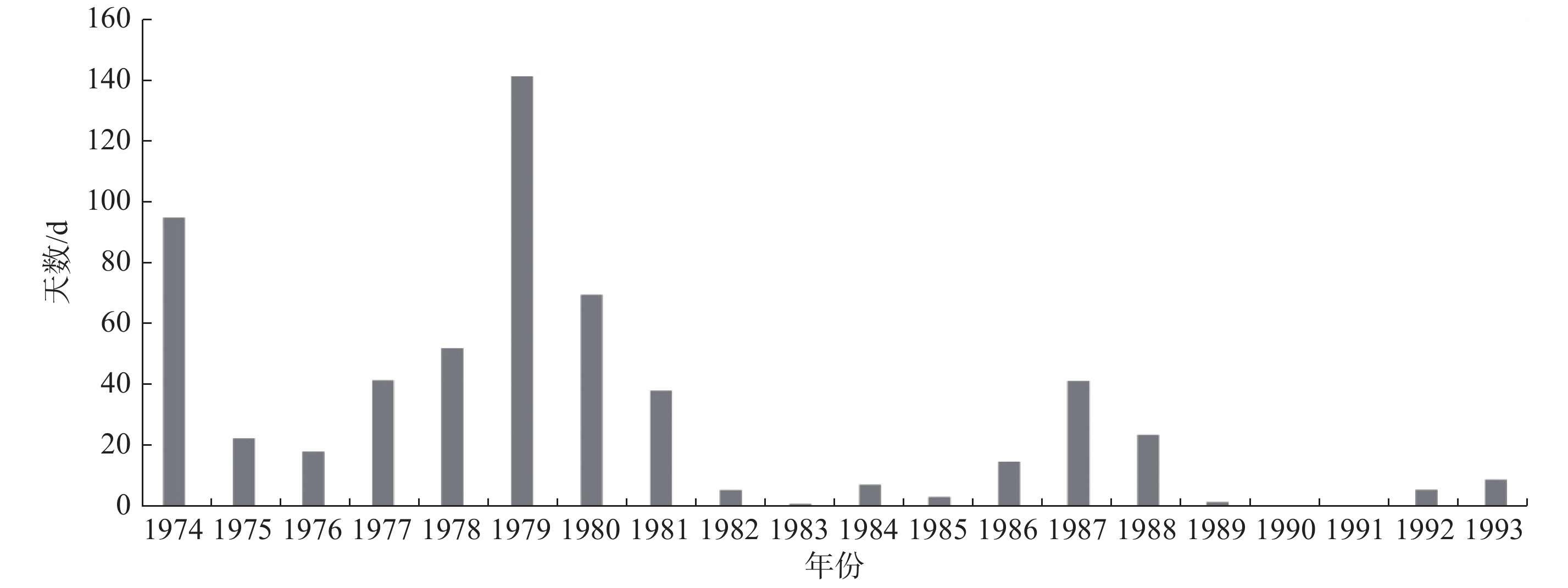
Table 1
Annual days of chlorinity greater than 250 mg/L at the water intake of the Wusong water plant from 1974 to 1993"
| 年份 | 天数/d | 年份 | 天数/d | 年份 | 天数/d | ||
| 1974 | 95 | 1981 | 39 | 1988 | 24 | ||
| 1975 | 23 | 1982 | 6 | 1989 | 2 | ||
| 1976 | 19 | 1983 | 2 | 1990 | 0 | ||
| 1977 | 43 | 1984 | 8 | 1991 | 0 | ||
| 1978 | 52 | 1985 | 4 | 1992 | 6 | ||
| 1979 | 140 | 1986 | 15 | 1993 | 10 | ||
| 1980 | 70 | 1987 | 42 |
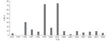
Fig.7
Days of saltwater intrusion at the water intake of the Chenhang reservoir from 1994 to 2008"
Table 2
Annual days of chlorinity greater than 250 mg/L at the water intake of the Chenhang reservoir from 1994 to 2008"
| 年份 | 天数/d | 年份 | 天数/d | 年份 | 天数/d | ||
| 1994 | 5 | 1999 | 73 | 2004 | 10 | ||
| 1995 | 0 | 2000 | 18 | 2005 | 7 | ||
| 1996 | 31 | 2001 | 75 | 2006 | 9 | ||
| 1997 | 14 | 2002 | 10 | 2007 | 10 | ||
| 1998 | 9 | 2003 | 3 | 2008 | 6 |

Fig.8
Annual days of saltwater intrusion at the water intake of the Qingcaosha reservoir from 2011 to 2020"
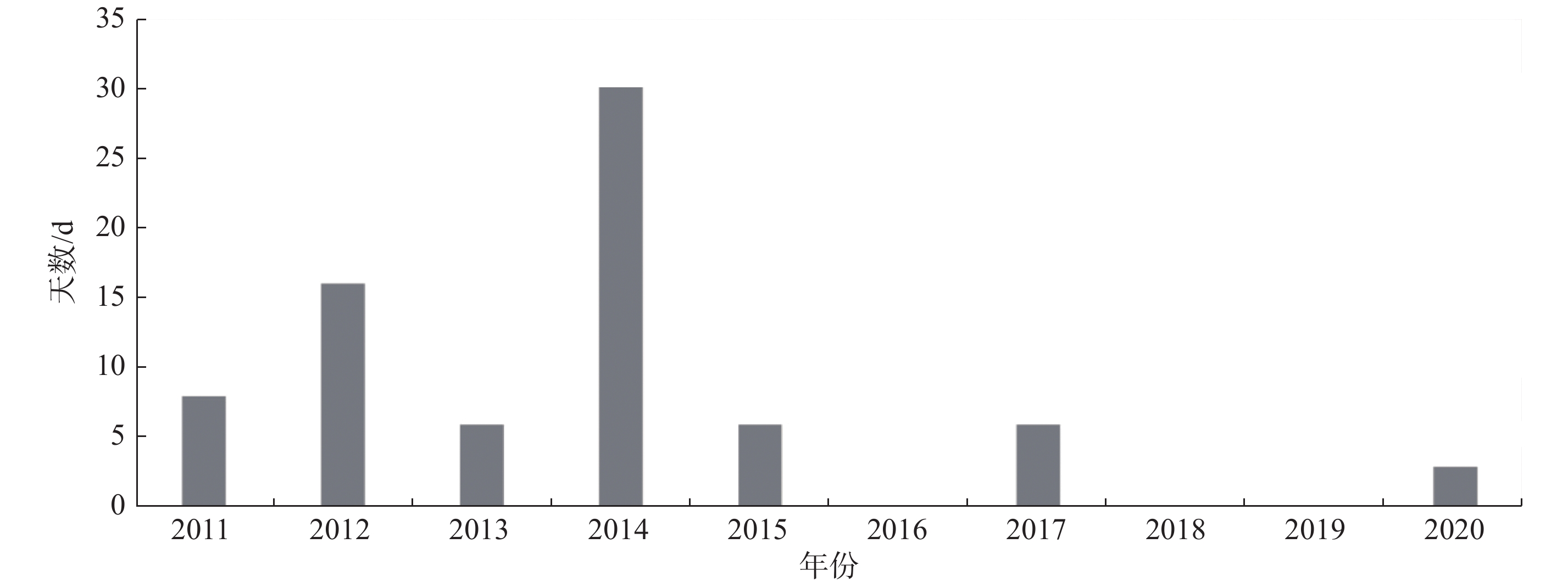
Table 3
Annual days of chlorinity greater than 250 mg/L at the water intake of the Qingcaosha reservoir from 2011 to 2020"
| 年份 | 天数/d | 年份 | 天数/d | 年份 | 天数/d | ||
| 2011 | 8 | 2015 | 6 | 2019 | 0 | ||
| 2012 | 16 | 2016 | 0 | 2020 | 3 | ||
| 2013 | 6 | 2017 | 6 | ||||
| 2014 | 30 | 2018 | 0 |
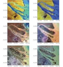
Fig.9
Satellite remote sensing images of the Changjiang Estuary from 1974 to 2013"

| 1 | BOWDEN K F. Circulation, salinity and river discharge in the Mersey Estuary. Geophysical Journal of the Royal Astronomical Society, 1966, (10): 383- 400. |
| 2 |
SIMPSON J H, BROWN J, MATTHEWS J, et al. Tidal straining, density currents, and stirring in the control of estuarine stratification. Estuaries, 1990, 13, 125- 132.
doi: 10.2307/1351581 |
| 3 | GEYER W R. The importance of suppression of turbulence by stratification on the estuarine turbidity maximum[J]. Estuaries and Coasts, 1993, 16: 113-125. |
| 4 |
MACCREADY P. Toward a unified theory of tidally-averaged estuarine salinity structure. Estuaries, 2004, 27, 561- 570.
doi: 10.1007/BF02907644 |
| 5 |
PRANDLE D. On salinity regimes and the vertical structure of residual flows in narrow tidal estuaries. Estuarine, Coastal and Shelf Science, 1985, 20 (5): 615- 635.
doi: 10.1016/0272-7714(85)90111-8 |
| 6 | 宋志尧, 茅丽华. 长江口盐水入侵研究. 水资源保护, 2002, (3): 27- 30. |
| 7 | 沈焕庭, 茅志昌, 朱建荣. 长江河口盐水入侵 [M]. 北京: 海洋出版社, 2003: 15-74. |
| 8 | 罗小峰, 陈志昌. 径流和潮汐对长江口盐水入侵影响数值模拟研究[J]. 海岸工程, 2005, 24(3): 1-6. |
| 9 | WU H, ZHU J R, CHEN B R, et al. Quantitative relationship of runoff and tide to saltwater spilling over from the North Branch in the Changjiang Estuary: A numerical study. Estuarine, Coastal and Shelf Science, 2006, 69 (1): 125- 132. |
| 10 | 朱建荣, 吴辉, 李路, 等. 极端干旱水文年 (2006) 中长江河口的盐水入侵. 华东师范大学学报 (自然科学版), 2010, (4): 1- 6. |
| 11 | 唐建华, 徐建益, 赵升伟, 等. 基于实测资料的长江河口南支河段盐水入侵规律分析. 长江流域资源与环境, 2011, (6): 677- 684. |
| 12 |
QIU C, ZHU J R, GU Y L. Impact of seasonal tide variation on saltwater intrusion in the Changjiang River Estuary. Chinese Journal of Oceanology and Limnology, 2012, 30, 342- 351.
doi: 10.1007/s00343-012-1115-x |
| 13 |
QIU C, ZHU J R. Influence of seasonal runoff regulation by the Three Gorges Reservoir on saltwater intrusion in the Changjiang River Estuary. Continental Shelf Research, 2013, 71, 16- 26.
doi: 10.1016/j.csr.2013.09.024 |
| 14 |
LI L, ZHU J R, WU H. Impacts of wind stress on saltwater intrusion in the Yangtze Estuary. Science China Earth Sciences, 2012, 55 (7): 1178- 1192.
doi: 10.1007/s11430-011-4311-1 |
| 15 |
ARISTIZABAL M F, CHANT R J. An observational study of salt fluxes in Delaware Bay. Journal of Geophysical Research Oceans, 2015, 120, 2751- 2768.
doi: 10.1002/2014JC010680 |
| 16 |
GIDDINGS S N, MACCREADY P. Reverse estuarine circulation due to local and remote wind forcing, enhanced by the presence of along-coast estuaries. Journal of Geophysical Research: Oceans, 2017, 122, 10184- 10205.
doi: 10.1002/2016JC012479 |
| 17 |
ZHU J R, CHENG X Y, LI L J, et al. Dynamic mechanism of an extremely severe saltwater intrusion in the Changjiang Estuary in February 2014. Hydrology and Earth System Sciences, 2020, 24, 5043- 5056.
doi: 10.5194/hess-24-5043-2020 |
| 18 |
AN Q, WU Y Q, TAYLOR S, et al. Influence of the Three Gorges Project on saltwater intrusion in the Yangtze River Estuary. Environmental Geology, 2009, 56 (8): 1679- 1686.
doi: 10.1007/s00254-008-1266-4 |
| 19 |
XU K, ZHU J R, GU Y L. Impact of the eastern water diversion from the south to the north project on the saltwater intrusion in the Changjiang Estuary in China. Acta Oceanologica Sinica, 2012, 31 (3): 47- 58.
doi: 10.1007/s13131-012-0205-0 |
| 20 |
LI L, ZHU J R, WU H, et al. Lateral saltwater intrusion in the North Channel of the Changjiang Estuary. Estuaries and Coasts, 2014, 37 (1): 36- 55.
doi: 10.1007/s12237-013-9669-1 |
| 21 | 陈泾, 朱建荣. 长江河口北支新村沙围垦工程对盐水入侵的影响. 华东师范大学学报 (自然科学版), 2014, (4): 163- 172. |
| 22 | 李林江, 朱建荣. 长江口南汇边滩围垦工程对流场和盐水入侵的影响. 华东师范大学学报 (自然科学版), 2015, (4): 154- 162. |
| 23 | 鲍道阳, 朱建荣. 近60年来长江河口河势变化及其对水动力和盐水入侵的影响Ⅲ 盐水入侵. 海洋学报, 2017, 39 (4): 1- 15. |
| 24 | 丁平兴, 王厚杰, 孟宪伟, 等. 近50年来我国典型海岸带演变过程与原因分析 [M]. 北京: 科学出版社, 2013: 98-106. |
| 25 | 沈焕庭, 茅志昌, 谷国传, 等. 长江河口盐水入侵的初步研究-兼谈南水北调. 人民长江, 1980, (3): 20- 26. |
| 26 | 徐建益, 袁建忠. 长江口南支河段盐水入侵规律的研究. 水文, 1994, 83 (5): 1- 6. |
| 27 | 肖成猷, 沈焕庭. 长江河口盐水入侵影响因子分析. 华东师范大学学报(自然科学版), 1998, (3): 74- 80. |
| 28 | LI L, ZHU J R, WU H, et al. A numerical study on the water diversion ratio of the Changjiang Estuary during the dry season. Chinese Journal of Oceanology and Limnology, 2010, 28 (3): 700- 712. |
| 29 | WU H, ZHU J R, CHOI B H. Links between saltwater intrusion and subtidal circulation in the Changjiang Estuary: A model-guided study. Continental Shelf Research, 2010, 30, 1891- 1905. |
| 30 | 韩乃斌. 长江口南支河段氯度变化分析. 水利水运科学研究, 1983, (1): 74- 81. |
| 31 | 茅志昌, 沈焕庭, 姚运达. 长江口南支南岸水域盐水入侵来源分析. 海洋通报, 1993, 12 (1): 17- 25. |
| 32 | 肖成猷, 朱建荣, 沈焕庭. 长江口北支盐水倒灌的数值模型研究. 海洋学报, 2000, 22 (5): 124- 132. |
| 33 | 茅志昌, 沈焕庭, 肖成献. 长江口北支盐水倒灌南支对青草沙水源地的影响. 海洋与湖沼, 2001, 32 (1): 58- 66. |
| 34 | 顾玉亮, 吴守培, 乐勤. 北支盐水入侵对长江口水源地影响研究. 人民长江, 2003, 34 (4): 1- 3. |
| 35 | 王国峰, 乐勤. 长江口北支盐水入侵对陈行水库取水口的影响. 城市给排水, 2003, 17 (4): 21- 22. |
| 36 | 吴辉, 朱建荣. 长江河口北支倒灌盐水输送机制分析. 海洋学报, 2007, 29 (1): 17- 25. |
| 37 | 陈泾, 朱建荣. 长江河口青草沙水库盐水入侵来源. 海洋学报, 2014, 36, 131- 141. |
| [1] | Zhi JIN, Jianrong ZHU, Wei QIU. Effects of cascade reservoirs in the Yangtze River Basin on estuarine saltwater intrusion and freshwater resources during late summer and early autumn [J]. Journal of East China Normal University(Natural Science), 2024, 2024(1): 90-103. |
| [2] | Wei QIU, Jianrong ZHU. Responses of saltwater intrusion in the Changjiang Estuary to various river discharge under a persistent and strong northerly wind [J]. Journal of East China Normal University(Natural Science), 2023, 2023(3): 132-146. |
| [3] | Zhipeng LI, Jianrong ZHU. Numerical simulation of the North Branch regime change impact on saltwater intrusion in the Yangtze River Estuary from 2007 to 2016 [J]. Journal of East China Normal University(Natural Science), 2022, 2022(3): 109-124. |
| [4] | Yunping SONG, Jianrong ZHU. Numerical simulation and analysis of the spatial and temporal variations in residual water levels of the Changjiang Estuary [J]. Journal of East China Normal University(Natural Science), 2021, 2021(4): 121-133. |
| [5] | Yiping ZHU. Analysis of the characteristics of the Qingcaosha Reservoir direct saltwater intrusion from the open sea in the Changjiang Estuary [J]. Journal of East China Normal University(Natural Science), 2021, 2021(2): 21-29. |
| [6] | Can GE, Weiguo ZHANG. Magnetic properties of particle-sized fractions of sediments in the Changjiang Estuary and neighboring shelf, and its environmental implications [J]. Journal of East China Normal University(Natural Science), 2021, 2021(2): 30-41. |
| [7] | Zhengdong YANG, Jianrong ZHU, Yunping SONG, Jinghua GU. Spatial and temporal variations in the residual water level of the Changjiang Estuary and its cause [J]. Journal of East China Normal University(Natural Science), 2021, 2021(2): 12-20. |
| [8] | ZHU Jianrong, LU Peiyi, TANG Chuanmin, CHEN Qing, Lü Hanghang. Numerical simulation of saltwater intrusion mitigation by building a sluice in the North Branch of the Changjiang Estuary [J]. Journal of East China Normal University(Natural Science), 2020, 2020(3): 13-22. |
| [9] | TANG Chuanmin, ZHU Jianrong. Influence of water level rise on currents and saltwater intrusion in the Changjiang Estuary [J]. Journal of East China Normal University(Natural Science), 2020, 2020(3): 23-31. |
| [10] | SU Aiping, Lü Hanghang, WU Yufan. Impact of the South-to-North Water Diversion Project on saltwater intrusion and freshwater resources in the Changjiang Estuary [J]. Journal of East China Normal University(Natural Science), 2020, 2020(3): 32-42. |
| [11] | ZHU Ping, WU Hui. Water mass transport and its controlling mechanisms between the Changjiang Estuary and Subei Coastal Water during the summer [J]. Journal of East China Normal University(Natural Sc, 2018, 2018(4): 171-183. |
| [12] | BAI Mei, WU Hui. Characteristics of sea surface temperature in the Changjiang Estuary and adjacent waters based on a Self-Organizing Map [J]. Journal of East China Normal University(Natural Sc, 2018, 2018(4): 184-194. |
| [13] | LI Guo-ping, ZHU Jian-rong. Analyses of saltwater intrusion at the water intake of Qingcaosha reservoir in the Changjiang Estuary in dry season from 2015 to 2017 [J]. Journal of East China Normal University(Natural Sc, 2018, 2018(2): 160-169. |
| [14] | YANG Wan-lun, DAO Fu-hai, LUAN Hua-long, GE Jian-zhong, DING Ping-xing. Study of the ebb sediment diversion ratios during wet season in the South and North Passage, Changjiang Estuary [J]. Journal of East China Normal University(Natural Sc, 2018, 2018(2): 170-180. |
| [15] | LI Yuan, LI Zhan-hai, ZHANG Zhao, WANG Zhi-gang, YAO Hong-yi. Vertical distribution patterns of suspended sediment concentration in the North Passage of the Changjiang Estuary [J]. Journal of East China Normal University(Natural Sc, 2017, 2017(6): 114-125. |
| Viewed | ||||||
|
Full text |
|
|||||
|
Abstract |
|
|||||