 中国综合性科技类核心期刊(北大核心)
Journal of East China Normal University(Natural Science) ›› 2022, Vol. 2022 ›› Issue (1): 135-147.doi: 10.3969/j.issn.1000-5641.2022.01.015
• Geography • Previous Articles Next Articles
Jiahao LI, Bo TIAN*( ), Fang CAO, Yuekai HU, Yuanqiang DUAN, Zehao XIE, Ya PENG, Wenhao JIANG, Huifang FAN
Received:2020-10-16
Online:2022-01-25
Published:2022-01-18
Contact:
Bo TIAN
E-mail:btian@sklec.ecnu.edu.cn
CLC Number:
Jiahao LI, Bo TIAN, Fang CAO, Yuekai HU, Yuanqiang DUAN, Zehao XIE, Ya PENG, Wenhao JIANG, Huifang FAN. Remote sensing inversion and time-series analysis of critical parameters for eutrophication assessment of urban waters in Shanghai[J]. Journal of East China Normal University(Natural Science), 2022, 2022(1): 135-147.
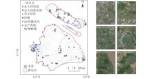
Fig.1
Study area and in-situ data collected "
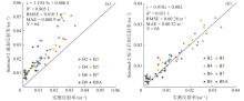
Fig.2
Comparison between in-situ measured reflectance and Sentinel-2 surface reflectance (a), and in-situ measured reflectance and Sentinel-2 surface reflectance after removal of sun glint (b) "
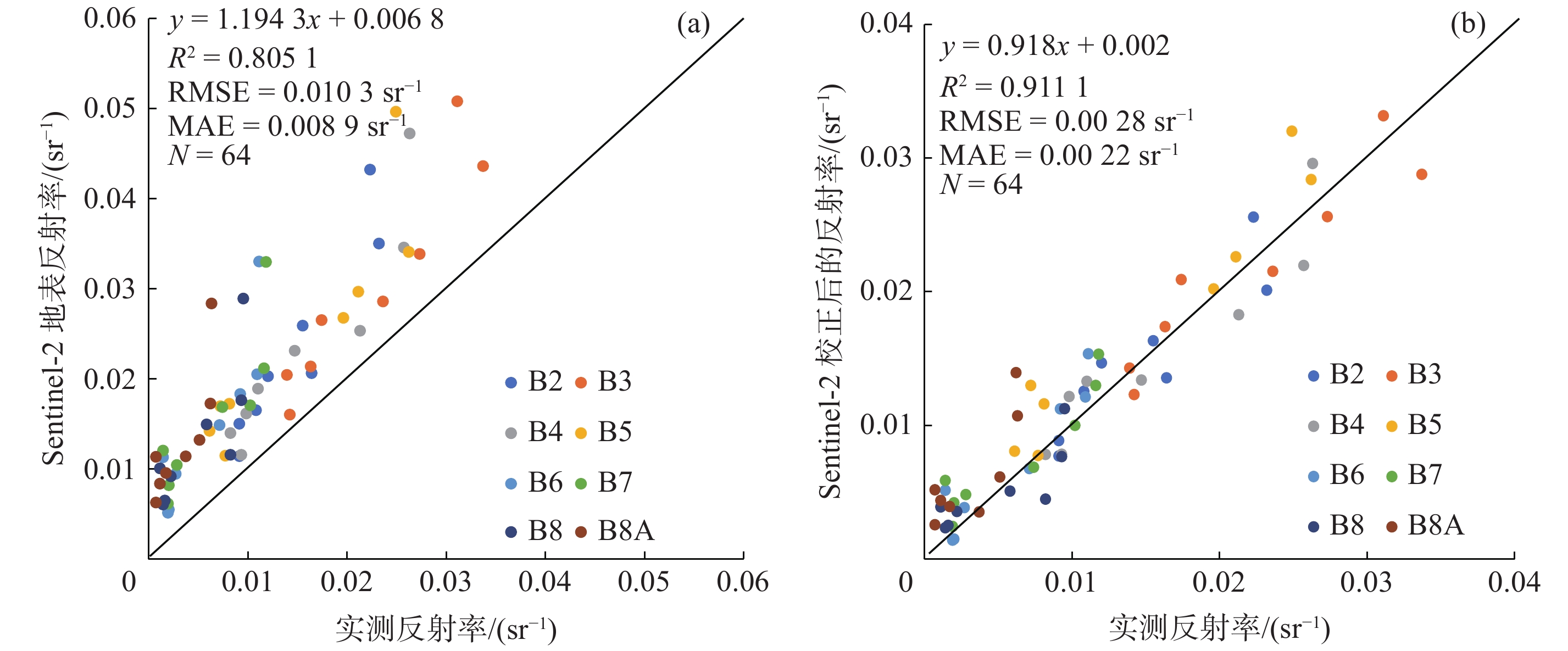
Table 1
Accuracy evaluation for classification of the three water body indexes"
| 水体指数 | 阈值 | 分类精度 | Kappa 系数 |
| NDWI | –0.2850 | 66.00% | 0.1636 |
| mNDWI | 0.0195 | 98.60% | 0.8814 |
| CIWI | 0.5112 | 60.10% | 0.1289 |
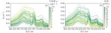
Fig.3
In-situ measured $ {{R}}_{\mathrm{r}\mathrm{s}} $ spectrum, with the corresponding Chl-a concentration (a) and turbidity (b) at each station color-coded "
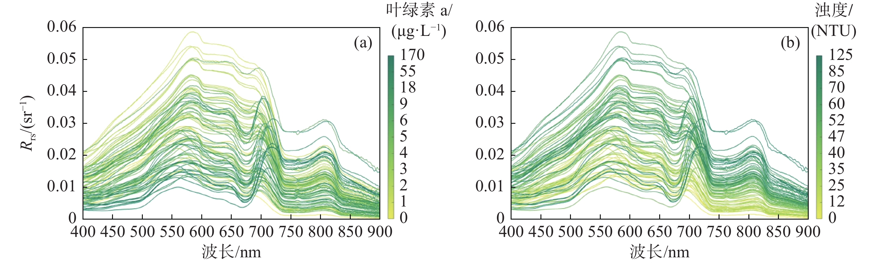
Table 2
Evaluation of Chl-a inversion algorithms"
| 序号 | 遥感因子 | 方程形式 | 参考模型 |
| 1 | x=Rrs(705)/Rrs(665) | y =3.2998x 3.8235 | Neil等[ |
| 2 | x= Rrs(705)/Rrs(665) | y=56.183x– 49.535 | Gilerson等[ |
| 3 | x= (Rrs(705)–Rrs(665))/ (Rrs(705) + Rrs(665)) | y=308.23x 2 + 78.224x + 4.6854 | Mishra等[ |
| 4 | Rrs(705)、Rrs(740)、Rrs(783)、Rrs(842) | 多元线性回归 | Maeda等[ |
| 5 | x=R–1rs(740)·(R–1rs(665)–R–1rs (705)) | y= 72.632x + 4.9605 | Dall等[ |

Fig.4
Comparison of Chl-a concentration between measured and model-derived data"
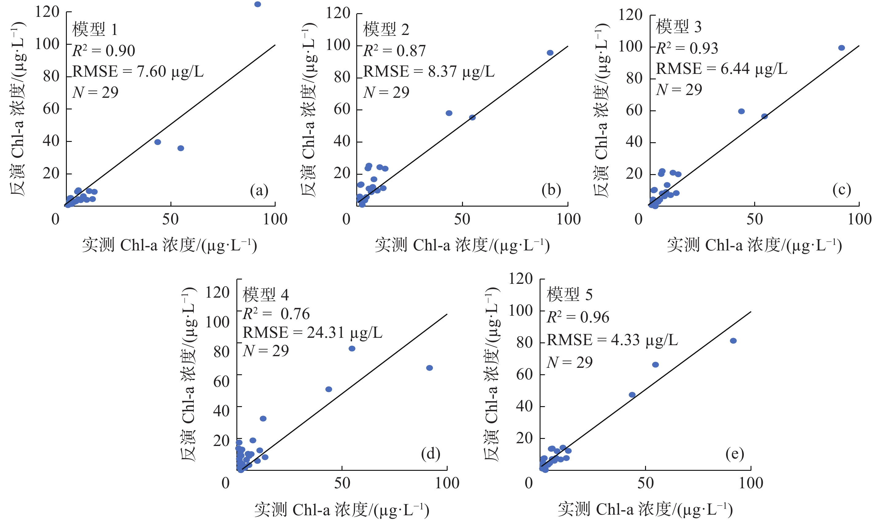

Fig.5
Validation results of Chl-a concentration (a) and turbidity (b) using Sentinel-2 data"
Table 3
Different turbidity inversion algorithms"
| 序号 | 遥感因子 | 方程形式 | 参考模型 |
| 1 | x = Rrs(665)/Rrs(490) | y = 2.5797e(2.1653x) | Kratzer等[ |
| 2 | x =Rrs(665)/Rrs(560) | y = 401.25x 2–579.43x + 240.59 | Hou等[ |
| 3 | x =Rrs(842)/Rrs(665) | y=62.167x0.65 | Doxaran等[ |
| 4 | x =Rrs(842) | y = –117312 x 2 + 7073x – 9.1356 | Petus等[ |
| 5 | Rrs(665)、Rrs(705)、Rrs(740)、Rrs(783)、Rrs(865) | 多元线性回归 | Maeda等[ |
| 6 | x = Rrs(783) | y = 4904.6x 1.0668 | 本文的方法 |
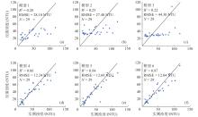
Fig.6
Comparison of turbidity between measured and model-derived data"
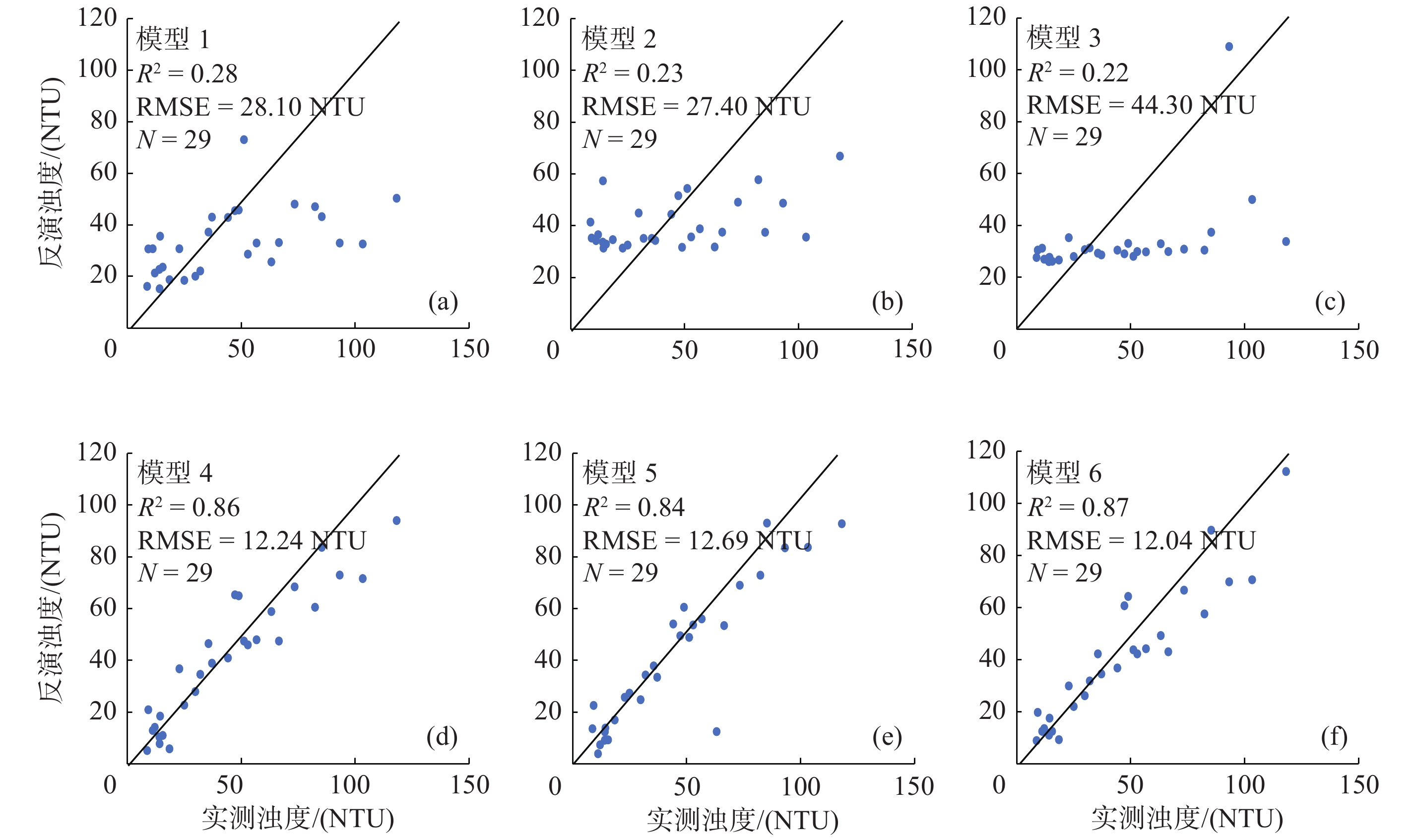
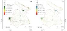
Fig.7
Distribution of annual mean of Chl-a and turbidity in 2019"

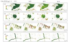
Fig.8
Inversion results of Chl-a in inland water bodies in Shanghai"
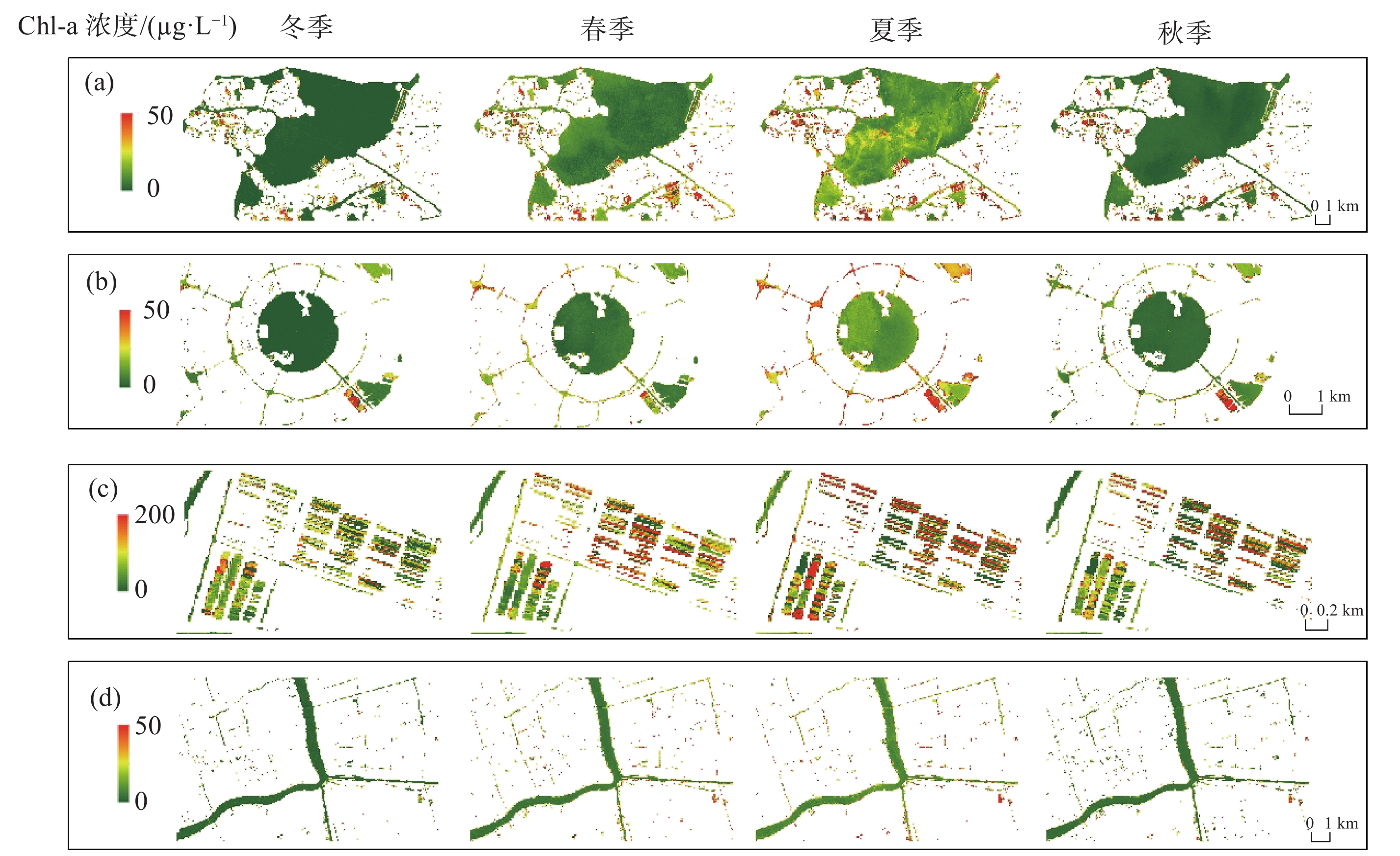
Fig.9
Inversion results of turbidity of inland water bodies in Shanghai"

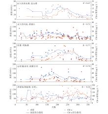
Fig.10
Time-series variation of Chl-a and turbidity in different water bodies in 2019"

| 1 |
HOU X, FENG L, DUAN H, et al. Fifteen-year monitoring of the turbidity dynamics in large lakes and reservoirs in the middle and lower basin of the Yangtze River, China. Remote Sensing of Environment, 2017, 190, 107- 121.
doi: 10.1016/j.rse.2016.12.006 |
| 2 |
PAERL H W. Assessing and managing nutrient-enhanced eutrophication in estuarine and coastal waters: Interactive effects of human and climatic perturbations. Ecological Engineering, 2006, 26 (1): 40- 54.
doi: 10.1016/j.ecoleng.2005.09.006 |
| 3 |
ANDERSON D M, GLIBERT P M, BURKHOLDER J M. Harmful algal blooms and eutrophication: Nutrient sources, composition, and consequences. Estuaries, 2002, 25 (4): 704- 726.
doi: 10.1007/BF02804901 |
| 4 | 2017年《中国生态环境状况公报》(摘录三)[J]. 环境保护, 2018, 46(13): 70-74. |
| 5 |
MOSES W J, GITELSON A A, BERDNIKOV S, et al. Estimation of chlorophyll- a concentration in case II waters using MODIS and MERIS data—successes and challenges. Environmental Research Letters, 2009, 4 (4): 45005.
doi: 10.1088/1748-9326/4/4/045005 |
| 6 |
金相灿, 朱萱. 我国主要湖泊和水库水体的营养特征及其变化. 环境科学研究, 1991, (1): 11- 20.
doi: 10.3321/j.issn:1001-6929.1991.01.003 |
| 7 |
SEBASTIÁ-FRASQUET M, AGUILAR-MALDONADO J A, SANTAMARÍA-DEL-ÁNGEL E, et al. Sentinel 2 analysis of turbidity patterns in a coastal lagoon. Remote Sensing, 2019, 11 (24): 2926.
doi: 10.3390/rs11242926 |
| 8 | 段洪涛, 张柏, 宋开山, 等. 查干湖叶绿素a浓度高光谱定量模型研究. 环境科学, 2006, (3): 3503- 3507. |
| 9 |
BILOTTA G S, BRAZIER R E. Understanding the influence of suspended solids on water quality and aquatic biota. Water Research, 2008, 42 (12): 2849- 2861.
doi: 10.1016/j.watres.2008.03.018 |
| 10 |
ERFTEMEIJER P L A, ROBIN LEWIS R R. Environmental impacts of dredging on seagrasses: A review. Marine Pollution Bulletin, 2006, 52 (12): 1553- 1572.
doi: 10.1016/j.marpolbul.2006.09.006 |
| 11 |
YANG Y, YAN B, SHEN W. Assessment of point and nonpoint sources pollution in Songhua River Basin, Northeast China by using revised water quality model. Chinese Geographical Science, 2010, 20 (1): 30- 36.
doi: 10.1007/s11769-010-0030-3 |
| 12 |
GUAN Q, FENG L, HOU X, et al. Eutrophication changes in fifty large lakes on the Yangtze Plain of China derived from MERIS and OLCI observations. Remote Sensing of Environment, 2020, 246, 111890.
doi: 10.1016/j.rse.2020.111890 |
| 13 | 黄启会, 贺中华, 梁虹, 等. 基于高光谱数据的百花湖叶绿素a浓度估算. 环境科学与技术, 2019, 42 (1): 134- 141. |
| 14 |
徐祎凡, 施勇, 李云梅. 基于环境一号卫星高光谱数据的太湖富营养化遥感评价模型. 长江流域资源与环境, 2014, 23 (8): 1111- 1118.
doi: 10.11870/cjlyzyyhj201408010 |
| 15 |
DRUSCH M, DEL BELLO U, CARLIER S, et al. Sentinel-2: ESA's optical high-resolution mission for GMES operational services. Remote Sensing of Environment, 2012, 120, 25- 36.
doi: 10.1016/j.rse.2011.11.026 |
| 16 |
阮仁良. 上海市水资源和水环境的可持续发展. 水资源保护, 2003, (1): 21- 24.
doi: 10.3969/j.issn.1004-6933.2003.01.006 |
| 17 |
TIAN B, ZHOU Y, THOM R M, et al. Detecting wetland changes in Shanghai, China using FORMOSAT and Landsat TM imagery. Journal of Hydrology, 2015, 529, 1- 10.
doi: 10.1016/j.jhydrol.2015.07.007 |
| 18 | 唐军武, 田国良, 汪小勇, 等. 水体光谱测量与分析Ⅰ: 水面以上测量法. 遥感学报, 2004, (1): 37- 44. |
| 19 | MUELLER J L, MOREL A, FROUIN R, et al. Ocean optics protocols for satellite ocean color sensor validation, revision 4. Volume III: Radiometric measurements and data analysis protocols [R]. Goddard Space Flight Space Center, 2003. |
| 20 | RUESCAS A B, PEREIRA-SANDOVAL M, TENJO C, et al. Sentinel-2 atmospheric correction inter-comparison over two lakes in Spain and Peru-Bolivia [C/OL]. [2021-10-08]. https://isp.uv.es/papers/Ruescas16CLEO.pdf. |
| 21 |
SÒRIA-PERPINYÀ X, VICENTE E, URREGO P, et al. Remote sensing of cyanobacterial blooms in a hypertrophic lagoon (Albufera of València, Eastern Iberian Peninsula) using multitemporal Sentinel-2 images. Science of the Total Environment, 2020, 698, 134305.
doi: 10.1016/j.scitotenv.2019.134305 |
| 22 |
HEDLEY J D, HARBORNE A R, MUMBY P J. Technical note: Simple and robust removal of sun glint for mapping shallow-water benthos. International Journal of Remote Sensing, 2005, 26 (10): 2107- 2112.
doi: 10.1080/01431160500034086 |
| 23 | 徐涵秋. 利用改进的归一化差异水体指数(MNDWI)提取水体信息的研究. 遥感学报, 2005, (5): 589- 595. |
| 24 |
MEHMET S, BÜLENT S. Survey over image thresholding techniques and quantitative performance evaluation. Journal of Electronic Imaging, 2004, 13 (1): 146- 165.
doi: 10.1117/1.1631315 |
| 25 | O'REILLY J E , MARITORENA S , SIEGEL D A , et al. Ocean color chlorophyll-a algorithms for SeaWiFS, OC2, and OC4: Version 4 [R]. Seawifs Post Launch Calibration & Validation Analyses, 2000: 9-23. |
| 26 |
GILERSON A A, GITELSON A A, ZHOU J, et al. Algorithms for remote estimation of chlorophyll-a in coastal and inland waters using red and near infrared bands. Opt Express, 2010, 18 (23): 24109- 24125.
doi: 10.1364/OE.18.024109 |
| 27 |
NEIL C, SPYRAKOS E, HUNTER P D, et al. A global approach for chlorophyll-a retrieval across optically complex inland waters based on optical water types. Remote Sensing of Environment, 2019, 229, 159- 178.
doi: 10.1016/j.rse.2019.04.027 |
| 28 |
MAEDA E E, LISBOA F, KAIKKONEN L, et al. Temporal patterns of phytoplankton phenology across high latitude lakes unveiled by long-term time series of satellite data. Remote Sensing of Environment, 2019, 221, 609- 620.
doi: 10.1016/j.rse.2018.12.006 |
| 29 |
MISHRA S, MISHRA D R. Normalized difference chlorophyll index: A novel model for remote estimation of chlorophyll-a concentration in turbid productive waters. Remote Sensing of Environment, 2012, 117, 394- 406.
doi: 10.1016/j.rse.2011.10.016 |
| 30 |
DALL OLMO G, GITELSON A A. Effect of bio-optical parameter variability on the remote estimation of chlorophyll-a concentration in turbid productive waters: Experimental results. Applied Optics, 2005, 44 (3): 412- 422.
doi: 10.1364/AO.44.000412 |
| 31 |
SALAMA M S, VERHOEF W. Two-stream remote sensing model for water quality mapping: 2SeaColor. Remote Sensing of Environment, 2015, 157, 111- 122.
doi: 10.1016/j.rse.2014.07.022 |
| 32 |
PETUS C, CHUST G, GOHIN F, et al. Estimating turbidity and total suspended matter in the Adour River plume (South Bay of Biscay) using MODIS 250-m imagery. Continental Shelf Research, 2010, 30 (5): 379- 392.
doi: 10.1016/j.csr.2009.12.007 |
| 33 |
DOXARAN D, FROIDEFOND J, CASTAING P, et al. Dynamics of the turbidity maximum zone in a macrotidal estuary (the Gironde, France): Observations from field and MODIS satellite data. Estuarine, Coastal and Shelf Science, 2009, 81 (3): 321- 332.
doi: 10.1016/j.ecss.2008.11.013 |
| 34 |
KRATZER S, KYRYLIUK D, EDMAN M, et al. Synergy of satellite, in situ and modelled data for addressing the scarcity of water quality information for eutrophication assessment and monitoring of Swedish Coastal Waters. Remote Sensing, 2019, 11 (17): 2051.
doi: 10.3390/rs11172051 |
| 35 |
BOWERS D G, BRAITHWAITE K M, NIMMO-SMITH W A M, et al. Light scattering by particles suspended in the sea: The role of particle size and density. Continental Shelf Research, 2009, 29 (14): 1748- 1755.
doi: 10.1016/j.csr.2009.06.004 |
| 36 | 赵雷, 廖晓斌, 周真明, 等. 泉州某水库水质季节变化原因及对策探究. 中国给水排水, 2020, 36 (1): 36- 42. |
| 37 | 李志波, 季丽, 李丹丹, 等. 罗非鱼精养池塘水质变化规律和沉积物产污系数研究. 环境科学与技术, 2015, 38 (5): 168- 174. |
| 38 |
VANHELLEMONT Q, RUDDICK K. Atmospheric correction of metre-scale optical satellite data for inland and coastal water applications. Remote Sensing of Environment, 2018, 216, 586- 597.
doi: 10.1016/j.rse.2018.07.015 |
| [1] | Ruiping SHI, Bicheng LI, Chunqing Wen, Yunfei ZHANG, Qianqian WU, Xiangkun QIN. Arrangement and analysis of type specimens of the Shanghai Natural History Museum Herbarium [J]. Journal of East China Normal University(Natural Science), 2024, 2024(4): 82-99. |
| [2] | Yong ZHANG, Hui WANG, Chuanhua ZHU, Hao ZHOU, Yu ZHAN, Can LI, Yifan XIAO, Lili YANG, Jiaqi LIU. Evaluation of eutrophication by satellite remote sensing based on machine learning: A case study of Huancheng River in Hefei [J]. Journal of East China Normal University(Natural Science), 2024, 2024(1): 1-8, 112. |
| [3] | Qianwen TANG, Qingyun LI, Tao LIU, Dan CHEN. Analysis on perennial herbs in the rural plant landscape of Shanghai [J]. Journal of East China Normal University(Natural Science), 2023, 2023(3): 53-63. |
| [4] | Xiaoling WANG, Kun SONG, Ying LE, Jing CHEN, Hao JIANG, Yongjia ZHANG, Heyi GONG, Zifei WANG, Yi DING, Tianhui SHI, Liangjun DA. Relationship between air pollution purification and forest belt width of the Shanghai green belt in the summer season [J]. Journal of East China Normal University(Natural Science), 2021, 2021(3): 128-137. |
| [5] | Lu LI, Xiaotao DU. The distribution of peak wind speeds induced by typhoons along the coasts of the Changjiang Estuary and Hangzhou Bay [J]. Journal of East China Normal University(Natural Science), 2021, 2021(2): 1-11. |
| [6] | WANG Huaxiang, CHU Xiaoye, CHEN Ying, XU Lu, YANG Kai. A study on temporal and spatial distribution characteristics of dissolved oxygen in surface water of megacities [J]. Journal of East China Normal University(Natural Science), 2020, 2020(6): 154-163. |
| [7] | ZHANG Hongli, YIN Guoyu, ZHENG Yanling, GAO Juan, GAO Dengzhou, CHANG Yongkai, LIU Cheng. Response of nitrogen removal in the overlying water to sediment resuspension in the intertidal wetlands of the Yangtze Estuary [J]. Journal of East China Normal University(Natural Science), 2020, 2020(3): 78-87. |
| [8] | ZHOU Yunchang, HE Yan, CHEN Jinghan, HUANG Minsheng. Performance of lime-based algae control in urban landscape water [J]. Journal of East China Normal University(Natural Science), 2020, 2020(1): 103-109. |
| [9] | ZHANG Xuan-yi, SHI Run-he. The impact of urban service facilities on house price dispersion [J]. Journal of East China Normal University(Natural Sc, 2019, 2019(6): 169-178. |
| [10] | WU Zhen, CHEN Rui-shan. A comparative analysis of the Ocean Health Index and the Pressure-State-Response evaluation methods for Shanghai's ocean ecosystem health [J]. Journal of East China Normal University(Natural Sc, 2019, 2019(4): 174-187. |
| [11] | CHENG Rui-hui, FAN Qun-jie, WANG Yu-kun, LIU Yao-yi, CHE Yue. A discussion on river network vulnerability in Shanghai based on the PSR model [J]. Journal of East China Normal University(Natural Sc, 2019, 2019(3): 144-154. |
| [12] | HAN Yu-jie, SUN Wen, ZHANG Wen-wen. Evaluation of ecosystem services for urban forests in Shanghai based on a distribution measurement methodology [J]. Journal of East China Normal University(Natural Sc, 2019, 2019(2): 147-155. |
| [13] | XU Yi-wen, HAN Jing, HE Yan, HUANG Min-sheng. A review of the effect of endogenous sulfur on the environmental behavior of phosphorus in sediment from polluted rivers and lakes [J]. Journal of East China Normal University(Natural Sc, 2018, 2018(6): 74-80. |
| [14] | CHEN Jie, YAO Shen-jun, WU Jian-ping, HUANG Le-le, REN Zhe-hao. Study on spatial distribution of residential care facilities in Shanghai [J]. Journal of East China Normal University(Natural Sc, 2018, 2018(3): 157-169. |
| [15] | SHI Hong-liang, SHI Jian-yong, YUAN Xiao, BO Shun-qi. Seicercus affinis and records of eleven other new birds in Shanghai [J]. Journal of East China Normal University(Natural Sc, 2018, 2018(3): 184-189. |
| Viewed | ||||||
|
Full text |
|
|||||
|
Abstract |
|
|||||