 中文核心期刊
Journal of East China Normal University(Natural Science) ›› 2021, Vol. 2021 ›› Issue (3): 138-150.doi: 10.3969/j.issn.1000-5641.2021.03.014
• Estuary and Coastal Research • Previous Articles Next Articles
Fei TENG1,2,*( ), Lu LI1,2, Zhuyuan BEI3, Jun WANG3, Jufei QIU4, Xiaojie ZHANG4
Received:2020-05-10
Online:2021-05-25
Published:2021-05-26
Contact:
Fei TENG
E-mail:373663745@qq.com
CLC Number:
Fei TENG, Lu LI, Zhuyuan BEI, Jun WANG, Jufei QIU, Xiaojie ZHANG. Application of a surface and river network coupled model on waterlogging distribution analysis and risk assessment for a region suffering from extreme storm surges[J]. Journal of East China Normal University(Natural Science), 2021, 2021(3): 138-150.

Fig.1
Distributions of plan rivers and lakes in Jinshan District"
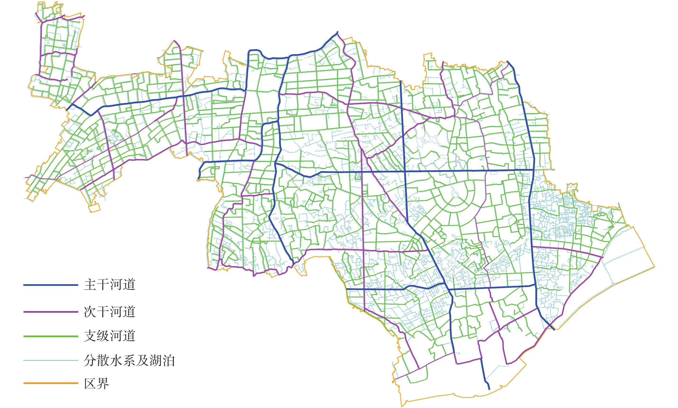

Fig.2
Range and framework of the 1-D river network model and the 2-D surface model"
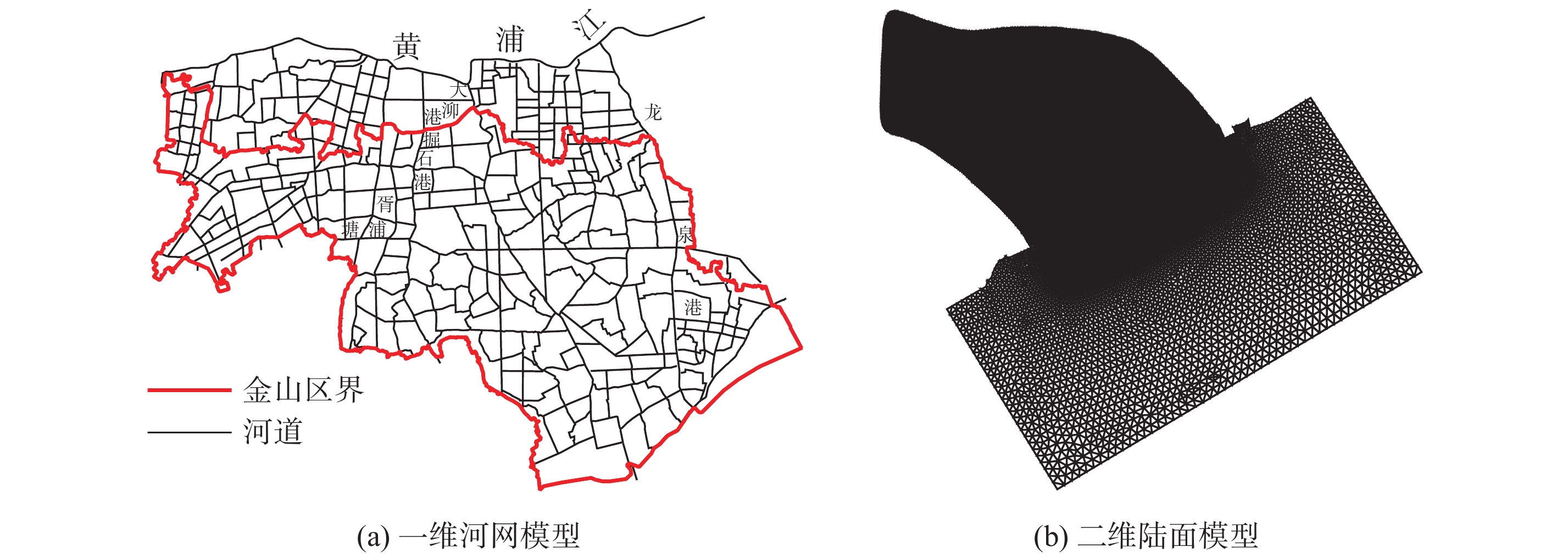

Fig.3
Construction of the 1-D and 2-D coupled model"
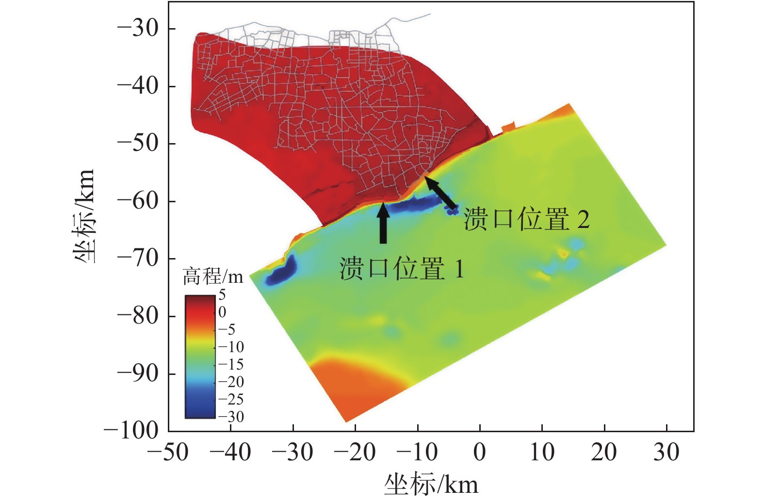

Fig.4
Hourly distribution of precipitation with “Fate” pattern and 20-year return period over 24 hours"
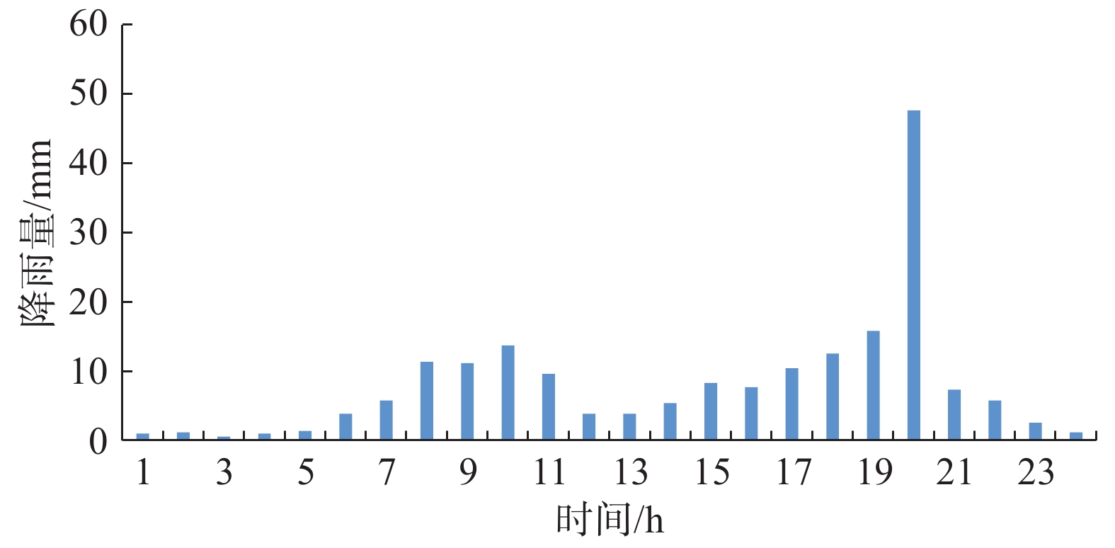
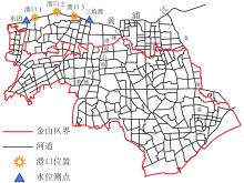
Fig.5
Location of the Hongqitang to Yuanxiejing breach at the upper Huangpu River"

Table 1
Calculation conditions"
| 计算工况 | 有无河道 | 有无降雨 | 有无流域洪水 |
| 工况0 | 无 | 无 | 无 |
| 工况1 | 有 | 无 | 无 |
| 工况2 | 有 | 有(“菲特”雨型) | 无 |
| 工况3 | 有 | 有(“菲特”雨型) | 有 |

Fig.6
The quantity of total inflow, surface waterlogging, and stream channel storage during a storm surge event with (and without) considering the river network in Jinshan district"
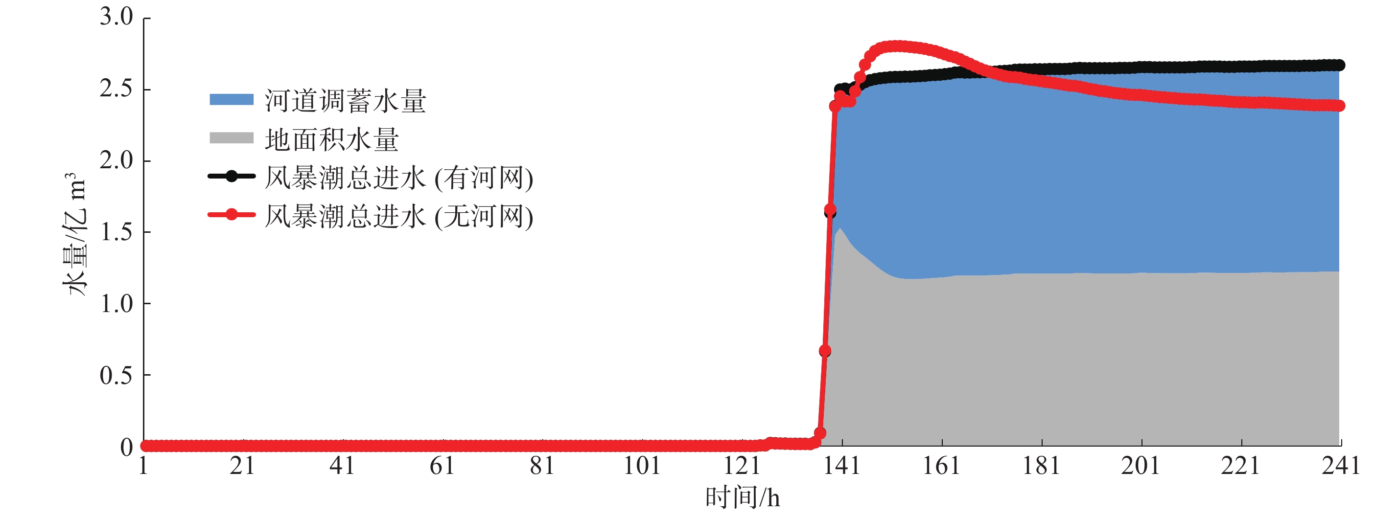
Table 2
Statistics on water accumulation in Jinshan District at a characteristic time under different calculation conditions"
| 计算工况 | 时刻 | 风暴潮进水量/(亿m3) | 降雨产流量/(亿m3) | 地表积水量/(亿m3) | 河道调蓄量/(亿m3) | 区域总水量/(亿m3) |
| 工况0 | 150 h | 2.81 | 2.81 | 2.81 | ||
| 240 h | 2.39 | 2.39 | 2.39 | |||
| 工况1 | 140 h | 2.51 | 1.54 | 0.97 | 2.51 | |
| 240 h | 2.67 | 1.22 | 1.45 | 2.67 | ||
| 工况2 | 140 h | 2.47 | 1.14 | 2.58 | 1.03 | 3.61 |
| 240 h | 2.70 | 1.17 | 2.36 | 1.51 | 3.87 | |
| 工况3 | 140 h | 2.47 | 1.14 | 2.58 | 1.03 | 3.61 |
| 240 h | 2.70 | 1.17 | 2.36 | 1.51 | 3.87 |
Fig.7
Distribution of maximum surface waterlogging during a storm surge event under calculation condition 0 (left) and calculation condition 1 (right)"
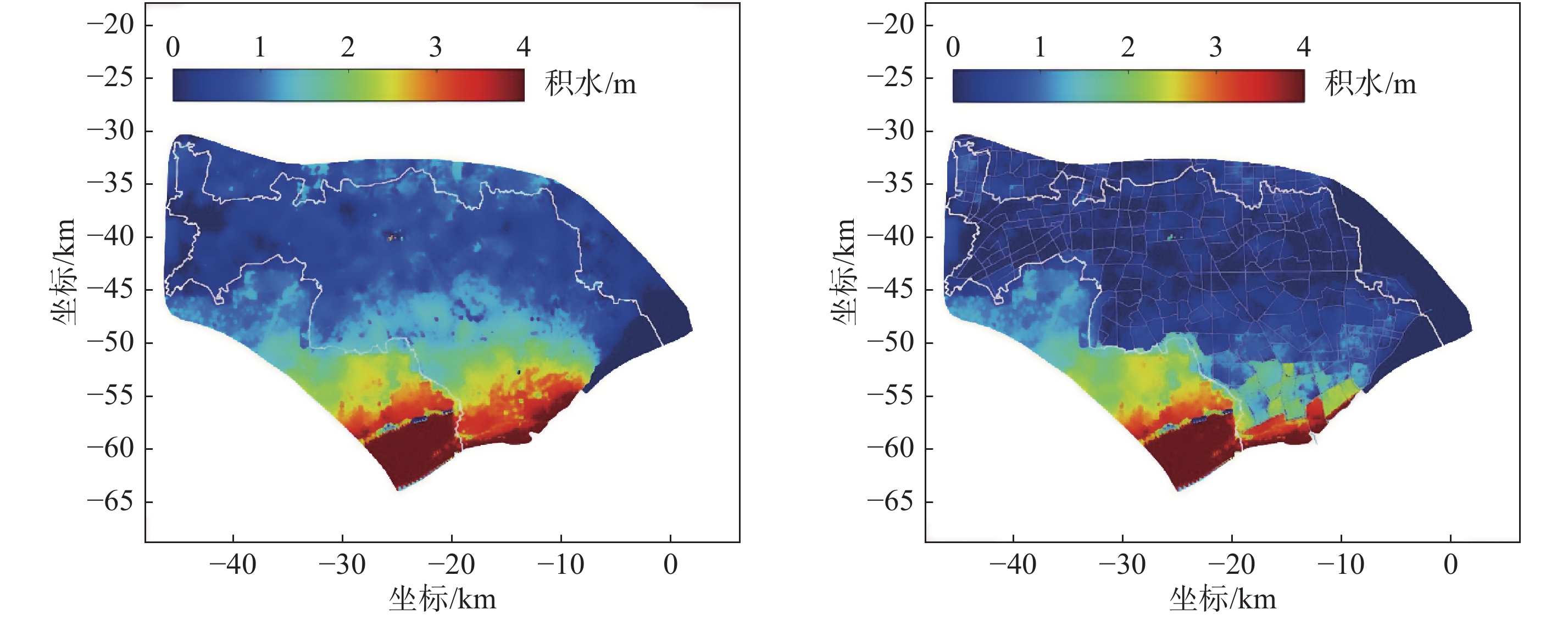
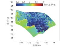
Fig.8
Difference in maximum waterlogging depth with the river network included and excluded during a storm surge event (i.e., calculation condition 1 minus calculation condition 0)"
Table 3
Maximum area and depth of waterlogging in Jinshan District under different calculation conditions"
| 计算工况 | 最大积水面积/km2 | 平均最大积水深度/cm | 最大积水深度/m |
| 工况0 | 561.74 | 115.65 | 7.71 |
| 工况1 | 426.39 | 71.29 | 7.70 |
| 工况2 | 603.87 | 72.95 | 7.70 |
| 工况3 | 603.87 | 73.46 | 7.70 |
Fig.9
(a) Maximum area and depth of surface waterlogging during a storm surge event with regional precipitation (calculation condition 2); (b) Maximum area and depth of surface waterlogging during a storm surge event with regional precipitation and flooding (calculation condition 3)"
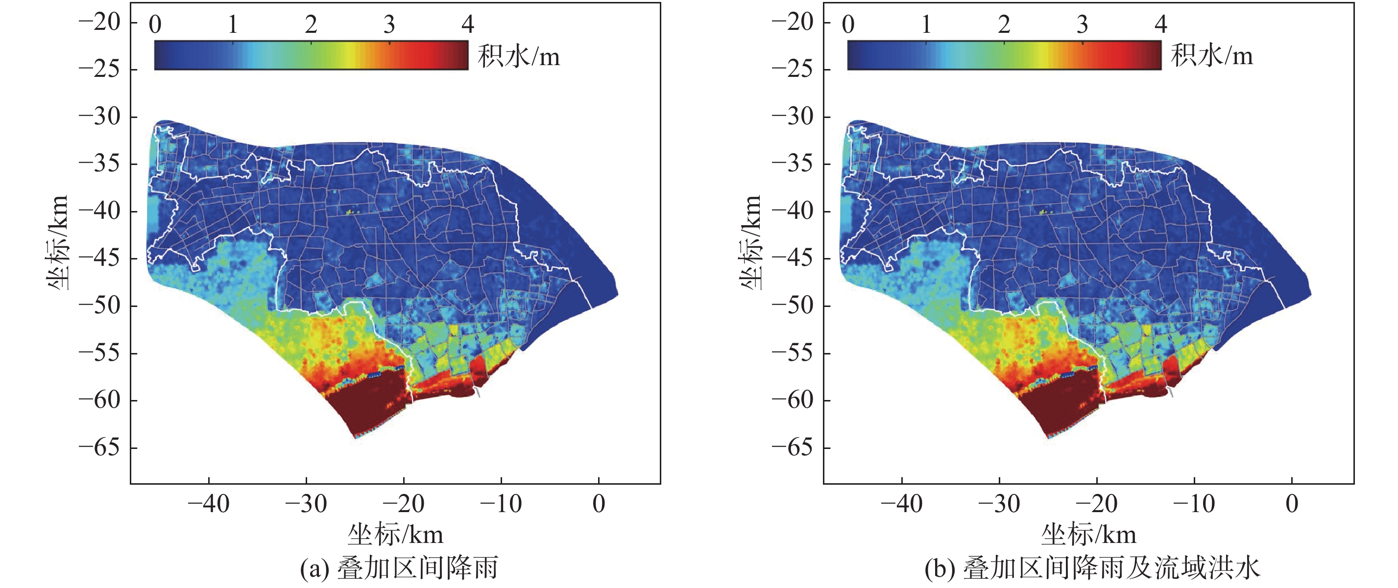
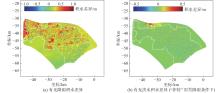
Fig.10
(a) Difference in maximum waterlogging depth with precipitation included and excluded during a storm surge event (i.e., calculation condition 2 minus calculation condition 1); (b) Difference in maximum waterlogging depth with flood included and excluded during a storm surge event (calculation condition 3 minus calculation condition 2)"

Table 4
Risk level of waterlogging depth at the city or county level"
| 危险性等级 | 淹没水深d/cm |
| Ⅰ | d ≥ 300 |
| Ⅱ | 120 ≤ d < 300 |
| Ⅲ | 50 ≤ d < 120 |
| Ⅳ | 15 ≤ d < 50 |
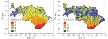
Fig.11
Risk level distribution in Jinshan District under calculation condition 0(left) and calculation condition 3 (right)"

Table 5
Waterlogging area for different risk levels in Jinshan District under calculation condition 0 and calculation condition 3"
| 计算工况 | 不同危险性等级面积/km2 | 合计面积/km2 | |||
| Ⅰ | Ⅱ | Ⅲ | Ⅳ | ||
| 工况0 | 35.04 | 144.84 | 275.74 | 95.76 | 551.39 |
| 工况3 | 17.99 | 66.92 | 226.41 | 281.17 | 592.49 |
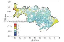
Fig.12
Change in waterlogging risk level from calculation condition 0 to calculation condition 3 in Jinshan District (+ denotes rise, – denotes fall)"
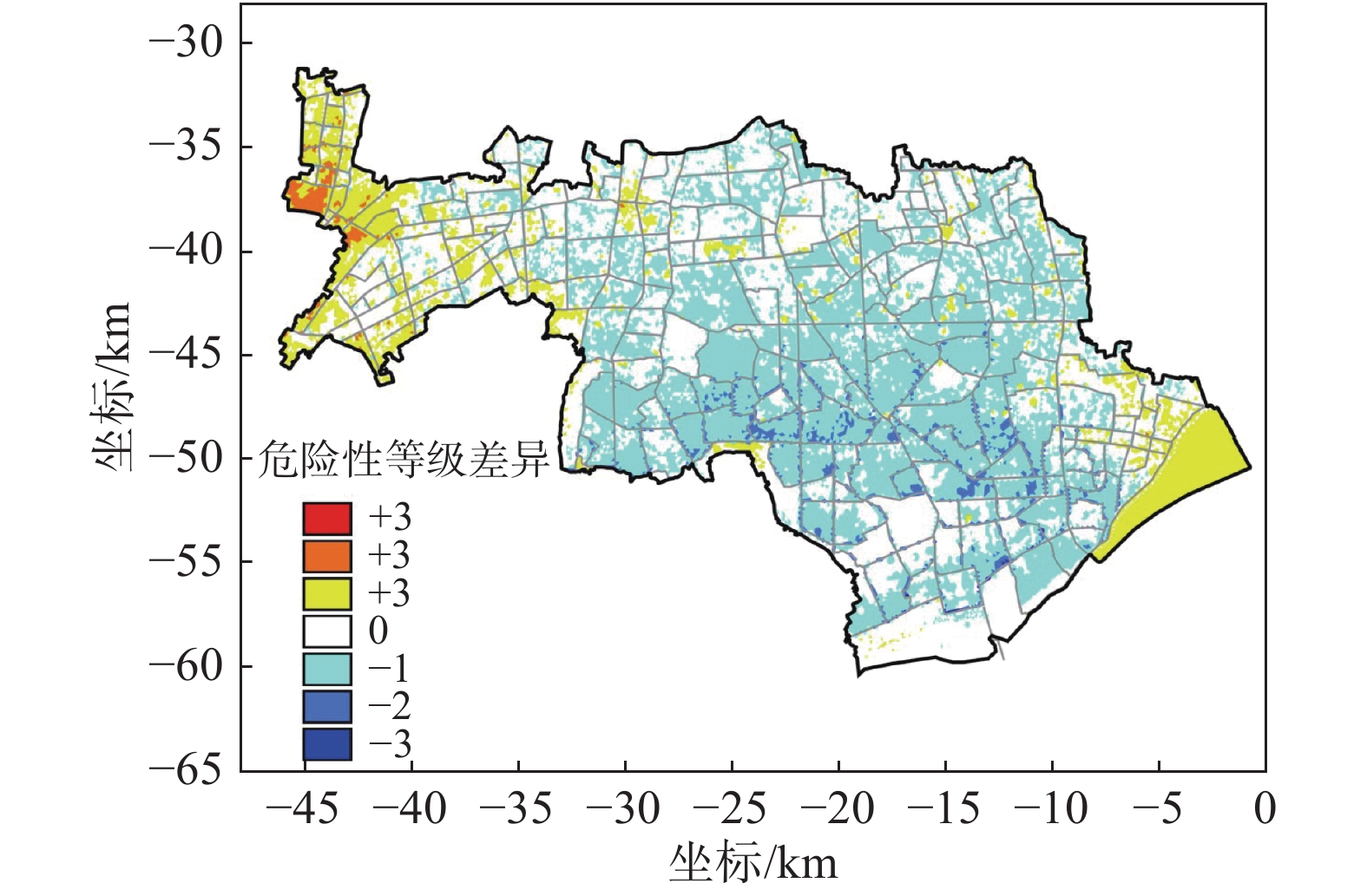
Table 6
Statistics on changes in risk level for waterlogging area in Jinshan District from calculation condition 0 to calculation condition 3"
| 危险性等级差异 | 变化面积/km2 | 变化占比/% | 危险性等级差异 | 变化面积/km2 | 变化占比/% | |
| +3等级 | 0.02 | 0 | –1等级 | 243.33 | 40.30 | |
| +2等级 | 4.71 | 0.78 | –2等级 | 22.27 | 3.69 | |
| +1等级 | 64.85 | 10.74 | –3等级 | 0.56 | 0.09 | |
| 0等级 | 268.13 | 44.40 | 合计 | 603.87 | 100 |
| 1 | 胡德宝, 龚茂珣, 孔亚珍. 强风暴潮对上海地区影响研究. 华东师范大学学报(自然科学版), 2005, (5/6): 177- 182. |
| 2 | 中华人民共和国自然资源部. 中国海洋灾害公报(1997—2003) [R/OL]. [2021-05-01]. http://www.mnr.gov.cn/sj/sjfw/hy/gbgg/zghyzhgb/. |
| 3 |
王军, 黄海雷, 张呈, 等. 浅谈上海应对风暴潮灾害的措施. 海洋开发与管理, 2017, 34 (1): 92- 96.
doi: 10.3969/j.issn.1005-9857.2017.01.018 |
| 4 | 王璐阳, 张敏, 温家洪, 等. 上海复合极端风暴洪水淹没模拟. 水科学进展, 2019, 30 (4): 546- 555. |
| 5 | 伍志元, 蒋昌波, 邓斌, 等. 基于海气耦合模式的南中国海北部风暴潮模拟. 科学通报, 2018, 63 (33): 3494- 3504. |
| 6 | 孙志林, 王辰, 钟汕虹, 等. 浪潮耦合的舟山渔港台风暴潮数值模拟. 海洋通报, 2019, 38 (2): 150- 158. |
| 7 | 李慧. 基于动态洪水演进模型的气候变化对沿海区影响研究. 水利水电快报, 2019, 40 (4): 4. |
| 8 | 张敏, 罗军, 胡金磊, 等. 雷州市沿海风暴潮淹没危险性评估. 热带海洋学报, 2019, 38 (2): 1- 12. |
| 9 | 刘秋兴, 李铖. 上游洪水对台风风暴潮过程期间长江口水位的影响研究. 海洋通报, 2017, 36 (2): 135- 142. |
| 10 |
朱军政, 于普兵. 钱塘江河口杭州湾风暴潮溢流计算方法研究. 水科学进展, 2009, 20 (2): 269- 274.
doi: 10.3321/j.issn:1001-6791.2009.02.018 |
| 11 | 殷杰. 中国沿海台风风暴潮灾害风险评估研究 [D]. 上海: 华东师范大学, 2011. |
| 12 | 叶明武. 沿海台风风暴潮灾害复合情景模拟与应急避难研究——以上海为例 [D]. 上海: 华东师范大学, 2011. |
| 13 | 朱彦鋆. 基于一维二维水动力模型的上海台风风暴潮淹没情景模拟与暴露分析 [D]. 上海: 上海师范大学, 2018. |
| 14 | 陈文想. 2008—2018年强台风对珠江口—横门及其上游的增水影响分析. 广东水利水电, 2019, (5): 28- 31. |
| 15 | 陈长太, 祁继英. 基于SWOT的上海防洪除涝形势分析. 中国防汛抗旱, 2019, 29 (6): 19- 22. |
| 16 | 季永兴, 刘水芹. 平原感潮地区雨型潮型组合对除涝规模的影响. 水利水电科技进展, 2017, 37 (5): 22- 27. |
| 17 | 钱真, 谭琼, 贾卫红. 城市雨洪综合模拟方法及应用. 水利水电科技进展, 2015, 35 (6): 57- 61. |
| 18 | 顾春林, 孙永清. 杭州湾金山卫岸段减灾对策浅述. 上海水利, 1990, (3): 51- 54. |
| 19 | 闫白洋. 海平面上升叠加风暴潮影响下上海市社会经济脆弱性评价 [D]. 上海: 华东师范大学, 2016. |
| 20 | 上海市城乡建设和交通委员会. 滩涂促淤圈围造地工程设计规范: DGTJ08-2111—2012 [S]. 上海: 上海市城乡建设和交通委员会, 2012. |
| 21 | 上海市水务局. 2020年上海市河道(湖泊)报告 [R]. 上海: 上海市水务局, 2021. |
| 22 | 上海市水务局. 上海市治涝标准: DB31T1121—2018 [S]. 上海: 上海市水务局, 2018. |
| 23 | 上海东海海洋工程勘察设计研究院. 上海市海洋灾害风险评估与区划(金山区) [R]. 上海: 上海东海海洋工程勘察设计研究院, 2017. |
| 24 | 国家海洋局. 风暴潮灾害风险评估和区划技术导则 [S]. 北京: 国家海洋局, 2015. |
| [1] | GAO Qin-qin, ZHU Jian-rong, DUAN Yi-hong, SUN Ming-hua. Impacts of the symmetrical and unsymmetrical typhoons on the storm surge simulation in the East China and the South China Seas [J]. Journal of East China Normal University(Natural Sc, 20120, 2012(6): 57-72. |
| [2] | CHENG Rui-hui, FAN Qun-jie, WANG Yu-kun, LIU Yao-yi, CHE Yue. A discussion on river network vulnerability in Shanghai based on the PSR model [J]. Journal of East China Normal University(Natural Sc, 2019, 2019(3): 144-154. |
| [3] | FU Yuan-chong, DING Ping-xing, GE Jian-zhong, ZONG Hai-bo. Development and application of the forecasting model for extratropical storm surges around the Changjiang estuary [J]. Journal of East China Normal University(Natural Sc, 2017, 2017(2): 116-125. |
| [4] | CHEN Jie, SONG Cheng-Cheng, LI Meng-Ya, WANG Jun-. Potential hazard assessment of typhoon storm surge based on scenario simulation methodology in Yuhuan County, Zhejiang Province [J]. Journal of East China Normal University(Natural Sc, 2016, 2016(3): 125-135. |
| [5] | KANG Xing,ZHANG Bei,DU Pan-jun,XU Ting-ting,ZHANG Hui. Statistical forecasting of storm surge under single stationobservations in Zhoushan island terrain [J]. Journal of East China Normal University(Natural Sc, 2015, 2015(4): 26-33. |
| [6] | SHEN Jie,ZHAO Jun,SHANG Zhao-yi. Analysis of the impact of landscape pattern change on the river network connectivity based on the spatial auto regression model [J]. Journal of East China Normal University(Natural Sc, 2015, 2015(3): 124-135. |
| [7] | WU Hui-Ming, GAO Qing-Qing. Sensitivity analysis of parameters in the numerical storm surge forecast model in the East China Sea [J]. Journal of East China Normal University(Natural Sc, 2014, 2014(6): 81-89. |
| [8] | LI Cheng, GE Jian-zhong, DING Ping-xing. Upgrades of the integrated visualized storm surge forecasting system in the Changjiang Estuary [J]. Journal of East China Normal University(Natural Sc, 2012, 2012(4): 190-195. |
| [9] | CHEN Hua-wei;GE Jian-zhong;DING Ping-xing. Analysis of storm surge’s process under the influence of waves [J]. Journal of East China Normal University(Natural Sc, 2010, 2010(4): 16-25. |
| [10] | QIN Yong-liang;YUAN Wen. Environmental flow calculation and assessmentin plain river network areas (Chinese) [J]. Journal of East China Normal University(Natural Sc, 2009, 2009(6): 71-78. |
| [11] | HUANG Hua;ZHU Jian-rong;WU Hui. 3D Numerical Simulation of Storm Surge in the Changjiang Estuary and the Hangzhou Bay(Chinese) [J]. Journal of East China Normal University(Natural Sc, 2007, 2007(4): 9-19. |
| [12] | GE Jian-zhong;HU Ke-lin;DING Ping-xing. Design and Application of Integrated Visualized Storm Surge Forecasting System(Chinese) [J]. Journal of East China Normal University(Natural Sc, 2007, 2007(4): 20-25. |
| [13] | CHE Yue;WU E-nuo;YANG Kai. Theories of Environmental Management for Water Source Protection in Plain River Network Region in East China(Chinese) [J]. Journal of East China Normal University(Natural Sc, 2007, 2007(2): 111-121. |
| [14] | HU De-bao;GONG Mao-xun;KONG Ya-zhen. Study of the Influence of Strong Storm Surges on Shanghai(Chinese) [J]. Journal of East China Normal University(Natural Sc, 2005, 2005(5/6): 177-182. |
| Viewed | ||||||
|
Full text |
|
|||||
|
Abstract |
|
|||||